Click here for more info on on SMS!

KDKR

HOUSTON COUNTY
CROCKETT
TX
Time Zone: Central
Lat: N 3118.4
Long: W 09524.2
Elev: 348
Var: -05
Longest Runway: 4000
AWOS: 118.77
CTAF: 122.9

FBO & Flight Services info for KDKR

FBOs: Update your Fuel Prices

HOUSTON COUNTYPh: 936-544-0656 Fax: N/A Freq: 122.9
Service
Jet
100LL
SAF
MoGas
Full        Last Update: 03/27/2024 12:48

Self  4.77    
 Address: 401 EAST GOLIAD ST 201   CROCKETT, TX 75835
AWOSPh: 936-545-8510
-
Freq: 118.77  
If you are an FBO, call 1-203-262-1700 to update your info or email: FltPlan.Advertising@garmin.com
Advertise your FBO on FltPlan.com

Runway & Approach Info for KDKR
Rwy
Length
Land Dist**
Approach*
  Rwy
Length
Land Dist**
Approach*
02
4000x75  4000'          
 
  
20
  4000x75  4000'          
 
 * only ILS, LOC, LDA, and SDF approaches to a specific runway are shown
** For any Declared Landing Distance Available, please see A/FD or Approach plates
Runway Weight Capability (lbs.) Help
Runway IDSingle WheelDouble WheelDouble Tandem WheelDual Double Wheel
02/2012,000N/AN/AN/A
These numbers are Advisory and are not limits.   The Airport Manager should have more accurate Weight Limits
Approach Charts
Approaches    
Current Weather/Notams
Customs Information Send updates to Support@FltPlan.com
Customs Not Available
Database effective 04/18/2024
Airport Diagram of KDKR
Airport Diagram might not be current.

Facility Name: HOUSTON COUNTY
City Name: CROCKETT
County: HOUSTON
State abbrev: TX
State Name: TEXAS
   
Ownership: PUBLICLY OWNED
Use: OPEN TO THE PUBLIC
Owner's Name: HOUSTON COUNTY
Address: HOUSTON COUNTY COURTHOUSE
 CROCKETT, TX 75835
Owner's Phone: 936-544-3255; EXT 221
  
Manager's Name: JIM LOVELL; COUNTY JUDGE
Address: HOUSTON COUNTY COURTHOUSE
 CROCKETT, TX 75835
Phone: 936-544-3255; EXTENSION 221.
   
FAA Region: SOUTHWEST
FAA Field Office: TEX


Sunrise / Sunset times for HOUSTON COUNTY

DateSunriseSunset
04/18/24 Thursday6:4919:53
04/19/24 Friday6:4819:53
04/20/24 Saturday6:4719:54
04/21/24 Sunday6:4619:55
04/22/24 Monday6:4519:55
04/23/24 Tuesday6:4419:56
04/24/24 Wednesday6:4319:57
04/25/24 Thursday6:4219:57
04/26/24 Friday6:4119:58
04/27/24 Saturday6:4019:59
04/28/24 Sunday6:3920:00
04/29/24 Monday6:3820:00
04/30/24 Tuesday6:3720:01
05/01/24 Wednesday6:3620:02

Airport Facilities

Airport Attendance ScheduleUNATTENDED
Airport Status OPERATIONAL (This Status can change at any time - please check NOTAMS)
Airport Lighting ScheduleMIRL RY 02/20 PRESET LOW INTST; TO INCR INTST ACTVT - CTAF. MIRLS OPER WITH PHOTOCELL OPERG ONLY AT NIGHT WITH SLCTBL INTST ON CTAF.
Airport Storage AvailableTie Downs
Extra Services AvailableCrop Dusting
Wind IndicatorYES - (lighted)
Control TowerNO
CTAF Frequency122.900
Unicom Frequency
Rotating Beacon ColorWG
Segmented CircleYES
Landing FeeNO

Airport Inspection Data

Airport InspectedSTATE - performed by PRIVATE CONTRACT PERSONNEL
Inspection Date10/05/2022

Airport Services

Type of Fuel AvailableGrade 100LL; -10SELF SERVE FUEL.
Airframe Repair ServiceMAJOR
Power Plant Repair ServiceMAJOR

Geographic Data

LatitudeN3118.4
LongitudeW09524.2 (ESTIMATED)
Arpt Elevation348ft (SURVEYED)
Magnetic Variation05E
3 miles SEof CROCKETT
Traffic Pattern Altitude
Sectional ChartHOUSTON

Aircraft Data

Operations (Reported)YearlyAvg. Daily
General Aviation Transient 22006
General Aviation Local 660018
Air Taxi 00
Commerical 00
Commuter 00
Military 00
Aircraft based on Field
General Aviation Singles 18
General Aviation Multi 2
Jet Aircraft 0
General Aviation Helicopters 0
Military Aircraft 0
Gliders 0
Ultralights 0

FAA Services

FSS on field NO
FSS tie-in MONTGOMERY COUNTY
FSS Phone 1-800-WX-BRIEF
Who issues Notams DKR
Notam D service at airport YES
ARTCC Name HOUSTON

Federal Status

Airport Certification
Aircraft Rescue & Firefighting IndexNone
Airport of EntryNo
Custom Landing RightsNo
Joint Civil/MilitaryNo
Military Landing rightsYES

Federal Agreements

NATIONAL PLAN OF INTEGRATED AIRPORT SYSTEMS (NPIAS)
GRANT AGREEMENTS UNDER FAAP/ADAP/AIP
ASSURANCES PURSUANT TO TITLE VI, CIVIL RIGHTS ACT OF 1964

Remarks

FOR CD CTC HOUSTON ARTCC AT 281-230-5622.
Airport Communications & Frequencies:
CTAF Frequency:
122.900
Remarks
  • APCH/DEP CTL SVC PRVDD BY HOUSTON ARTCC (ZHU) ON FREQS 134.8/269.6 (LUFKIN RCAG).
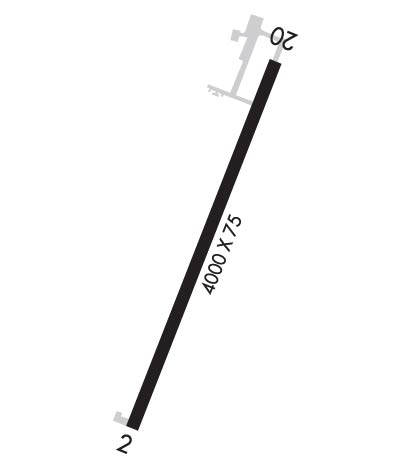
  • Runway Identifications
    Runway Identification: 02/20
    Length: 4000 ft
    Width: 75 ft
    Surface: ASPHALT-GOOD CONDITION
    Edge lights: Medium Intensity

    Treatment: NONE

     Runway: 02   Runway: 20
    Mag heading: 17°Mag heading: 197°
    Rwy Slope: .54% UpRwy Slope: -.54% Down
    Approach: Approach:
    Pattern: Left TrafficPattern: Left Traffic
    Markings: NONPRECISION INSTRUMENTMarkings: NONPRECISION INSTRUMENT
    Marking Condition: GOODMarking Condition: GOOD
    Arresting Dev: Arresting Dev:
    Lat & Long: N3118.1  W09524.4Lat. & Long.: N3118.7  W09524.1
    Elev: 326.7 ft. MSLElev: 348.4 ft. MSL
    TCH: 35 ft. AGLTCH: 35 ft. AGL
    Visual Glide Path: 3.00 degreesVisual Glide Path: 3.00 degrees
    Displaced Threshold: NoDisplaced Threshold: No
    Touchdown Zone: YESTouchdown Zone: YES
    Touchdown Elev.: 341.4 feetTouchdown Elev.: 348.4 feet
    Visual Glide Slope: 2-Light PAPI on LEFT side of Runway; PAPI OTS INDEFLY.Visual Glide Slope: 2-Light PAPI on LEFT side of Runway; PAPI OTS INDEFLY.
    RVR Equipment: RVR Equipment:
    RVV Equipment: NORVV Equipment: NO
    Approach Lights: Approach Lights:
    REIL: NOREIL: NO
    Centerline Lights: NOCenterline Lights: NO
    Touchdown lights: NOTouchdown lights: NO
    Runway Category: Runway with a Non-precision ApproachRunway Category: Runway with a Non-precision Approach
    Declared Distances: Declared Distances:
    Obstructions: TREE; ALSO 50 FT TREES, 1200 FT DSTC, 20:1.Obstructions: POLE
    Marked: NOT Marked/LightedMarked: NOT Marked/Lighted
    Clearance slope: 17:1Clearance slope: 26:1
    Obstruction height: 94 feet AGLObstruction height: 40 feet AGL
    Dist. from runway: 1860 feetDist. from runway: 1240 feet
    Centerline offset: 220 left of centerlineCenterline offset:
    Comments: Comments:
    C:1/P: