Current Weather/Notams (Metars, TAFs, Notams, NWS Forecast, PIREPS, and nearby weather)
Customs Information Send updates to Support@FltPlan.com
Customs Not Available
Database effective 05/16/2024
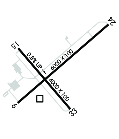
Airport Diagram might not be current. Facility Name: CHAUTAUQUA COUNTY/DUNKIRK City Name: DUNKIRK County: CHAUTAUQUA State abbrev: NY State Name: NEW YORK Ownership: PUBLICLY OWNED Use: OPEN TO THE PUBLIC Owner's Name: CHAUT CO Address: 3163 AIRPORT DR JAMESTOWN, NY 14701 Owner's Phone: 716-484-0204 Manager's Name: SHANNON A BARNHART Address: 3163 AIRPORT DR JAMESTOWN, NY 14701 Phone: (716) 661-8930 FAA Region: EASTERN FAA Field Office: NYC
Runway Identifications Help
Runway Identification: 06/24 Length: 6000 ftWidth: 100 ftSurface: ASPHALTEdge lights: High Intensity Treatment: GROOVED Runway: 06 Runway: 24 Mag heading: 59° Mag heading: 239° Rwy Slope: -.21% Down Rwy Slope: .21% Up Approach: Approach: Pattern: Left Traffic Pattern: Left Traffic Markings: NONPRECISION INSTRUMENT Markings: NONPRECISION INSTRUMENT Marking Condition: GOOD Marking Condition: GOOD Arresting Dev: Arresting Dev: Lat & Long: N4229.4 W07916.7 Lat. & Long.: N4230.0 W07915.7 Elev: 673.9 ft. MSL Elev: 661.5 ft. MSL TCH: 43 ft. AGL TCH: 44 ft. AGL Visual Glide Path: 3.00 degrees Visual Glide Path: 3.00 degrees Displaced Threshold: No Displaced Threshold: No Touchdown Zone: YES Touchdown Zone: YES Touchdown Elev.: 676.8 feet Touchdown Elev.: 673.2 feet Visual Glide Slope: 4-Light PAPI on LEFT side of Runway Visual Glide Slope: 4-Light PAPI on LEFT side of Runway RVR Equipment: RVR Equipment: RVV Equipment: NO RVV Equipment: NO Approach Lights: Approach Lights: REIL: YES REIL: YES Centerline Lights: NO Centerline Lights: NO Touchdown lights: NO Touchdown lights: NO Runway Category: Runway with a Visual Approach Runway Category: Runway with a Non-precision Approach having visibility minimums greater than 3/4 mile Declared Distances: Declared Distances: Obstructions: Obstructions: TREE Marked: Marked: NOT Marked/Lighted Clearance slope: 20:1 Clearance slope: 13:1 Obstruction height: Obstruction height: 56 feet AGL Dist. from runway: Dist. from runway: 942 feet Centerline offset: Centerline offset: 324 feet right of centerline Comments: Comments:
Runway Identification: 15/33 Length: 4000 ftWidth: 100 ftSurface: ASPHALT-FAIR CONDITIONEdge lights: Medium Intensity Treatment: NONE Runway: 15 Runway: 33 Mag heading: 149° Mag heading: 329° Rwy Slope: .80% Up Rwy Slope: -.80% Down Approach: Approach: Pattern: Left Traffic Pattern: Left Traffic Markings: NONPRECISION INSTRUMENT Markings: NONPRECISION INSTRUMENT Marking Condition: GOOD Marking Condition: GOOD Arresting Dev: Arresting Dev: Lat & Long: N4229.8 W07916.7 Lat. & Long.: N4229.3 W07916.1 Elev: 660.4 ft. MSL Elev: 692.3 ft. MSL TCH: 36 ft. AGL TCH: 45 ft. AGL Visual Glide Path: 3.00 degrees Visual Glide Path: 3.10 degrees Displaced Threshold: No Displaced Threshold: No Touchdown Zone: YES Touchdown Zone: YES Touchdown Elev.: 684.1 feet Touchdown Elev.: 692.3 feet Visual Glide Slope: 4-Light PAPI on LEFT side of Runway Visual Glide Slope: 4-Light PAPI on LEFT side of Runway RVR Equipment: RVR Equipment: RVV Equipment: NO RVV Equipment: NO Approach Lights: Approach Lights: REIL: NO REIL: NO Centerline Lights: NO Centerline Lights: NO Touchdown lights: NO Touchdown lights: NO Runway Category: Runway with a Non-precision Approach having visibility minimums greater than 3/4 mile Runway Category: Runway with a Non-precision Approach having visibility minimums greater than 3/4 mile Declared Distances: Declared Distances: Obstructions: TREE Obstructions: TREES Marked: NOT Marked/Lighted Marked: NOT Marked/Lighted Clearance slope: 10:1 Clearance slope: 15:1 Obstruction height: 56 feet AGL Obstruction height: 40 feet AGL Dist. from runway: 768 feet Dist. from runway: 815 feet Centerline offset: 326 right of centerline Centerline offset: 203 feet right of centerline Comments: Comments: