Click here for more info on on SMS!

KDKB

DE KALB TAYLOR MUNI
DE KALB
IL
Time Zone: Central
Lat: N 4156.0
Long: W 08842.3
Elev: 913
Var: +02
Longest Runway: 7026
AWOS: 119.07
CTAF: 122.7

FBO & Flight Services info for KDKB

FBOs: Update your Fuel Prices
DeKalb Airport offers unparalleled convenience for your corporate, charter, or GA needs. Pilot lounge, courtesy vehicles, Wi-Fi, JetA+ (afterhours callouts), 100LL self-serve 24/7. Newer hotels, excelllent restaurants, and NIU campus are minutes away.
Ph: 815-758-3521 Fax: 815-748-2022 Freq: 122.7WebsiteE-Mail
                     
Service
Jet
100LL
SAF
MoGas
Fuel Avail: PRIST PREMIXED. AFTR HRS CONTACT MGR Renee Riani @ (815) 762-5443
Full5.596.84    Last Update: 04/14/2024 09:22

Self  6.09    
Misc. Info: Jet A .10 cent/gallon discount 501 gallons or more.Address: 3232 PLEASANT ST,   DEKALB, IL 60115

AWOSPh: 815-748-2350
-
Freq: 119.07  
If you are an FBO, call 1-203-262-1700 to update your info or email: FltPlan.Advertising@garmin.com
Advertise your FBO on FltPlan.com

Runway & Approach Info for KDKB
Rwy
Length
Land Dist**
Approach*
  Rwy
Length
Land Dist**
Approach*
02
7026x100  7026'          
ILS/DME
 109.95 - 021°  
  
20
  7026x100  7026'          
 
09
4201x75  4201'          
 
  
27
  4201x75  4201'          
 
 * only ILS, LOC, LDA, and SDF approaches to a specific runway are shown
** For any Declared Landing Distance Available, please see A/FD or Approach plates
Runway Weight Capability (lbs.) Help
Runway IDSingle WheelDouble WheelDouble Tandem WheelDual Double Wheel
02/2025,00080,000N/AN/A
09/2725,00080,000N/AN/A
These numbers are Advisory and are not limits.   The Airport Manager should have more accurate Weight Limits
Approach Charts
Approaches    
Current Weather/Notams
Customs Information Send updates to Support@FltPlan.com
Customs Not Available
Database effective 05/16/2024
Airport Diagram of KDKB
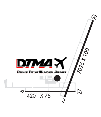
Airport Diagram might not be current.

Facility Name: DE KALB TAYLOR MUNI
City Name: DE KALB
County: DE KALB
State abbrev: IL
State Name: ILLINOIS
   
Ownership: PUBLICLY OWNED
Use: OPEN TO THE PUBLIC
Owner's Name: CITY OF DEKALB
Address: 164 EAST LINCOLN HWY
 DEKALB, IL 60115
Owner's Phone: 815-748-2000
  
Manager's Name: BENJAMIN TROMPETER
Address: 3232 PLEASANT STREET
 DEKALB, IL 60115
Phone: 815-748-8102
   
FAA Region: GREAT LAKES
FAA Field Office: CHI
2007-Courtesy of Vlad Van Maule (Filmontage, Inc.)


Click here for full scale & interactive Sectional view of KDKB


Sunrise / Sunset times for DE KALB TAYLOR MUNI

DateSunriseSunset
04/25/24 Thursday5:5819:48
04/26/24 Friday5:5719:49
04/27/24 Saturday5:5519:50
04/28/24 Sunday5:5419:51
04/29/24 Monday5:5319:52
04/30/24 Tuesday5:5119:53
05/01/24 Wednesday5:5019:54
05/02/24 Thursday5:4919:55
05/03/24 Friday5:4719:57
05/04/24 Saturday5:4619:58
05/05/24 Sunday5:4519:59
05/06/24 Monday5:4420:00
05/07/24 Tuesday5:4220:01
05/08/24 Wednesday5:4120:02

Airport Facilities

Airport Attendance ScheduleNOV-FEB 7 Days A Week 0800-1600, MAR-OCT 7 Days A Week 0800-1700
Airport Status OPERATIONAL (This Status can change at any time - please check NOTAMS)
Airport Lighting ScheduleMIRL RWY 02/20 PRESET LOW INTST, TO INCR INTST & ACTVT MIRL RWY 09/27, PAPI RWYS 09 & 27, REIL RWYS 09, 27, & 20, AND MALSR RWY 02 - CTAF. PAPI RWYS 02 & 20 OPERATE 24 HRS.
Airport Storage AvailableTie Downs, Hanger
Extra Services AvailableAir Freight, Cargo Handling, Flight Instruction, Aircraft Rental
Wind IndicatorYES - (lighted)
Control TowerNO
CTAF Frequency122.700
Unicom Frequency122.700
Rotating Beacon ColorWG
Segmented CircleNO
Landing FeeNO

Airport Inspection Data

Airport InspectedSTATE - performed by STATE AERONAUTICAL PERSONNEL
Inspection Date03/23/2021

Airport Services

Type of Fuel AvailableGrade 100LL, JET A-1 (icing inhibitor, freeze point -50C)
Airframe Repair ServiceMAJOR
Power Plant Repair ServiceMAJOR

Geographic Data

LatitudeN4156.0
LongitudeW08842.3 (ESTIMATED)
Arpt Elevation912ft (SURVEYED)
Magnetic Variation02W
2 miles Eof DE KALB
Traffic Pattern Altitude
Sectional ChartCHICAGO

Aircraft Data

Operations (Reported)YearlyAvg. Daily
General Aviation Transient 1970054
General Aviation Local 622017
Air Taxi 10803
Commerical 00
Commuter 00
Military 00
Aircraft based on Field
General Aviation Singles 69
General Aviation Multi 6
Jet Aircraft 0
General Aviation Helicopters 2
Military Aircraft 0
Gliders 0
Ultralights 0

FAA Services

FSS on field NO
FSS tie-in KANKAKEE
FSS Phone 1-800-WX-BRIEF
Who issues Notams DKB
Notam D service at airport YES
ARTCC Name CHICAGO

Federal Status

Airport Certification
Aircraft Rescue & Firefighting IndexNone
Airport of EntryNo
Custom Landing RightsNo
Joint Civil/MilitaryNo
Military Landing rightsYES

Federal Agreements

NATIONAL PLAN OF INTEGRATED AIRPORT SYSTEMS (NPIAS)
GRANT AGREEMENTS UNDER FAAP/ADAP/AIP
SURPLUS PROPERTY AGREEMENT UNDER REGULATION 16-WAA
ASSURANCES PURSUANT TO TITLE VI, CIVIL RIGHTS ACT OF 1964

Remarks

FOR CD CTC CHICAGO APCH AT 847-289-0926.
Airport Communications & Frequencies:
CTAF Frequency:
122.700
Unicom Frequency:
122.700
CHICAGO Primary Approach Frequencies:  
133.5
349.0
CHICAGO Primary Departure Frequencies:  
133.5
349.0
Runway Identifications
Runway Identification: 02/20
Length: 7026 ft
Width: 100 ft
Surface: ASPHALT-FAIR CONDITION
Edge lights: Medium Intensity

Treatment: GROOVED

 Runway: 02   Runway: 20
Mag heading: 21°Mag heading: 201°
Rwy Slope: -.13% DownRwy Slope: .13% Up
Approach: ILS/DMEApproach:
Pattern: Left TrafficPattern: Left Traffic
Markings: PRECISION INSTRUMENTMarkings: NONPRECISION INSTRUMENT
Marking Condition: FAIRMarking Condition: FAIR
Arresting Dev: Arresting Dev:
Lat & Long: N4155.7  W08842.4Lat. & Long.: N4156.7  W08841.9
Elev: 912.6 ft. MSLElev: 903.7 ft. MSL
TCH: 53 ft. AGLTCH: 29 ft. AGL
Visual Glide Path: 3.00 degreesVisual Glide Path: 3.00 degrees
Displaced Threshold: NoDisplaced Threshold: No
Touchdown Zone: YESTouchdown Zone: YES
Touchdown Elev.: 912.6 feetTouchdown Elev.: 905.0 feet
Visual Glide Slope: 4-Light PAPI on LEFT side of RunwayVisual Glide Slope: 4-Light PAPI on LEFT side of Runway
RVR Equipment: RVR Equipment:
RVV Equipment: NORVV Equipment: NO
Approach Lights: MALSR - 1,400 foot medium intensity approach lighting system with runway alignment indicator lightsApproach Lights:
REIL: NOREIL: YES
Centerline Lights: NOCenterline Lights: NO
Touchdown lights: NOTouchdown lights: NO
Runway Category: Precision Instrument RunwayRunway Category: D
Declared Distances: Declared Distances:
Obstructions: RRObstructions:
Marked: NOT Marked/LightedMarked:
Clearance slope: 50:1Clearance slope: 34:1
Obstruction height: 21 feet AGLObstruction height:
Dist. from runway: 1237 feetDist. from runway:
Centerline offset: 650 right of centerlineCenterline offset:
Comments: Comments:
Runway Identification: 09/27
Length: 4201 ft
Width: 75 ft
Surface: ASPHALT-FAIR CONDITION
Edge lights: Medium Intensity

Treatment: GROOVED

 Runway: 09   Runway: 27
Mag heading: 92°Mag heading: 272°
Rwy Slope: .01% UpRwy Slope: -.01% Down
Approach: Approach:
Pattern: Left TrafficPattern: Left Traffic
Markings: NONPRECISION INSTRUMENTMarkings: NONPRECISION INSTRUMENT
Marking Condition: FAIRMarking Condition: FAIR
Arresting Dev: Arresting Dev:
Lat & Long: N4155.7  W08843.1Lat. & Long.: N4155.7  W08842.2
Elev: 911.4 ft. MSLElev: 911.7 ft. MSL
TCH: 30 ft. AGLTCH: 24 ft. AGL
Visual Glide Path: 3.00 degreesVisual Glide Path: 3.00 degrees
Displaced Threshold: NoDisplaced Threshold: No
Touchdown Zone: YESTouchdown Zone: YES
Touchdown Elev.: 911.6 feetTouchdown Elev.: 911.7 feet
Visual Glide Slope: 4-Light PAPI on LEFT side of RunwayVisual Glide Slope: 4-Light PAPI on LEFT side of Runway
RVR Equipment: RVR Equipment:
RVV Equipment: NORVV Equipment: NO
Approach Lights: Approach Lights:
REIL: YESREIL: YES
Centerline Lights: NOCenterline Lights: NO
Touchdown lights: NOTouchdown lights: NO
Runway Category: Runway with a Non-precision Approach having visibility minimums greater than 3/4 mileRunway Category: D
Declared Distances: Declared Distances:
C:5/P: