Current Weather/Notams (Metars, TAFs, Notams, NWS Forecast, PIREPS, and nearby weather)
Customs Information Send updates to Support@FltPlan.com
Customs Not Available
Database effective 04/18/2024
Airport Diagram might not be current.
|
| Facility Name: | DICKINSON/THEODORE ROOSEVELT RGNL |
| City Name: | DICKINSON |
| County: | STARK |
| State abbrev: | ND |
| State Name: | NORTH DAKOTA |
| | |
| Ownership: | PUBLICLY OWNED |
| Use: | OPEN TO THE PUBLIC |
| Owner's Name: | DICKINSON ARPT AUTHORITY |
| Address: | 11120 42ND ST SW |
| | DICKINSON, ND 58601-9282 |
| Owner's Phone: | 701-483-1062 |
| | |
| Manager's Name: | KELLY BRAUN |
| Address: | 11120 42ND ST SW |
| | DICKINSON, ND 58601-9282 |
| Phone: | 701-483-1062 |
| | |
| FAA Region: | GREAT LAKES |
| FAA Field Office: | DMA |
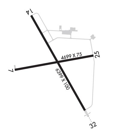
Runway Identifications
Runway Identification: 07/25Length: 4700 ft
Width: 75 ft
Surface: ASPHALT-GOOD CONDITION
Edge lights: Medium IntensityTreatment: GROOVED
Weight: PCN 5 /F/D/W/T
| | Runway: 07 | | Runway: 25 |
| Mag heading: | 70° | Mag heading: | 250° |
| Rwy Slope: | .43% Up | Rwy Slope: | -.43% Down |
| Approach: | | Approach: | |
| Pattern: | Left Traffic | Pattern: | Left Traffic |
| Markings: | NONPRECISION INSTRUMENT | Markings: | NONPRECISION INSTRUMENT |
| Marking Condition: | FAIR | Marking Condition: | GOOD |
| Arresting Dev: | | Arresting Dev: | |
| Lat & Long: | N4647.8 W10248.7 | Lat. & Long.: | N4647.9 W10247.6 |
| Elev: | 2571.7 ft. MSL | Elev: | 2592.1 ft. MSL |
| TCH: | 28 ft. AGL | TCH: | 28 ft. AGL |
| Visual Glide Path: | 3.00 degrees | Visual Glide Path: | 3.00 degrees |
| Displaced Threshold: | No | Displaced Threshold: | No |
| Touchdown Zone: | YES | Touchdown Zone: | YES |
| Touchdown Elev.: | 2582.6 feet | Touchdown Elev.: | 2592.1 feet |
| Visual Glide Slope: | 2-Light PAPI on LEFT side of Runway | Visual Glide Slope: | 2-Light PAPI on LEFT side of Runway |
| RVR Equipment: | | RVR Equipment: | |
| RVV Equipment: | NO | RVV Equipment: | NO |
| Approach Lights: | | Approach Lights: | |
| REIL: | YES | REIL: | YES |
| Centerline Lights: | NO | Centerline Lights: | NO |
| Touchdown lights: | NO | Touchdown lights: | NO |
| Runway Category: | Runway with a Non-precision Approach | Runway Category: | Runway with a Non-precision Approach |
| Declared Distances: | TORA:4700' TODA:4700' ASDA:4700' LDA:4700' | Declared Distances: | TORA:4700' TODA:4700' ASDA:4700' LDA:4700' |
| Obstructions: | | Obstructions: | ROAD |
| Marked: | | Marked: | NOT Marked/Lighted |
| Clearance slope: | 50:1 | Clearance slope: | 21:1 |
| Obstruction height: | | Obstruction height: | 28 feet AGL |
| Dist. from runway: | | Dist. from runway: | 790 feet |
| Centerline offset: | | Centerline offset: | 300 feet left of centerline |
| Comments: | | Comments: | |
Runway Identification: 14/32Length: 7301 ft
Width: 150 ft
Surface: CONCRETE
Edge lights: High IntensityTreatment: GROOVED
Weight: PCN 25 /R/B/W/T
| | Runway: 14 | | Runway: 32 |
| Mag heading: | 140° | Mag heading: | 320° |
| Rwy Slope: | .00% Down | Rwy Slope: | .00% Up |
| Approach: | | Approach: | ILS/DME |
| Pattern: | Left Traffic | Pattern: | Left Traffic |
| Markings: | PRECISION INSTRUMENT | Markings: | PRECISION INSTRUMENT |
| Marking Condition: | GOOD | Marking Condition: | GOOD |
| Arresting Dev: | | Arresting Dev: | |
| Lat & Long: | N4648.7 W10248.8 | Lat. & Long.: | N4647.6 W10247.9 |
| Elev: | 2581.8 ft. MSL | Elev: | 2581.5 ft. MSL |
| TCH: | 50 ft. AGL | TCH: | 50 ft. AGL |
| Visual Glide Path: | 3.00 degrees | Visual Glide Path: | 3.00 degrees |
| Displaced Threshold: | No | Displaced Threshold: | No |
| Touchdown Zone: | YES | Touchdown Zone: | YES |
| Touchdown Elev.: | 2585.2 feet | Touchdown Elev.: | 2586.7 feet |
| Visual Glide Slope: | 4-Light PAPI on LEFT side of Runway | Visual Glide Slope: | 4-Light PAPI on LEFT side of Runway |
| RVR Equipment: | | RVR Equipment: | |
| RVV Equipment: | NO | RVV Equipment: | NO |
| Approach Lights: | | Approach Lights: | MALSR - 1,400 foot medium intensity approach lighting system with runway alignment indicator lights |
| REIL: | YES | REIL: | NO |
| Centerline Lights: | NO | Centerline Lights: | NO |
| Touchdown lights: | NO | Touchdown lights: | NO |
| Runway Category: | D | Runway Category: | Precision Instrument Runway |
| Declared Distances: | TORA:7301' TODA:7301' ASDA:7301' LDA:7301' | Declared Distances: | TORA:7301' TODA:7301' ASDA:7301' LDA:7301' |
| Obstructions: | POLE | Obstructions: | ROAD |
| Marked: | NOT Marked/Lighted | Marked: | NOT Marked/Lighted |
| Clearance slope: | 38:1 | Clearance slope: | 50:1 |
| Obstruction height: | 65 feet AGL | Obstruction height: | 37 feet AGL |
| Dist. from runway: | 2686 feet | Dist. from runway: | 2344 feet |
| Centerline offset: | 676 left of centerline | Centerline offset: | 666 feet right of centerline |
| Comments: | | Comments: | |

