| ||||||||||||||||||||||||||||||||||||||||||||||||||||||||||||||||||||
| ||||||||||||||||||||||||||||||||||||||||||||||||||||||||||||||||||||
| ||||||||||||||||||||||||||||||||||||||||||||||||||||||||||||||||||||
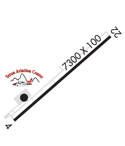
| Rwy | Rwy | |||||||
| 7300x100 | 7300' | 7300x100 | 7300' | |||||
| Runway ID | Single Wheel | Double Wheel | Double Tandem Wheel | Dual Double Wheel |
| 04/22 | 30,000 | 75,000 | N/A | N/A |
| These numbers are Advisory and are not limits. The Airport Manager should have more accurate Weight Limits | ||||
 Airport Diagram might not be current. | |
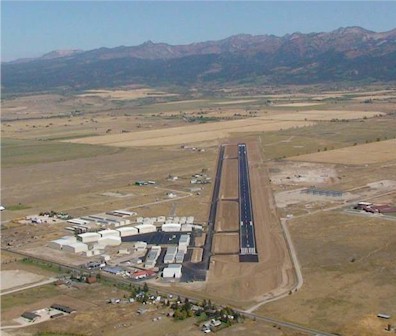
| Facility Name: | DRIGGS/REED MEML |
| City Name: | DRIGGS |
| County: | TETON |
| State abbrev: | ID |
| State Name: | IDAHO |
| Ownership: | PUBLICLY OWNED |
| Use: | OPEN TO THE PUBLIC |
| Owner's Name: | CITY OF DRIGGS |
| Address: | PO BOX 48 |
| DRIGGS, ID 83422 | |
| Owner's Phone: | 208-354-2362 |
| Manager's Name: | MEREDITH FOX |
| Address: | PO BOX 48 |
| DRIGGS, ID 83422 | |
| Phone: | 208-520-1015 |
| FAA Region: | NORTHWEST MOUNTAIN |
| FAA Field Office: | HLN |
| Date | Sunrise | Sunset |
|---|---|---|
| 04/19/24 Friday | 6:34 | 20:14 |
| 04/20/24 Saturday | 6:32 | 20:15 |
| 04/21/24 Sunday | 6:30 | 20:16 |
| 04/22/24 Monday | 6:29 | 20:17 |
| 04/23/24 Tuesday | 6:27 | 20:19 |
| 04/24/24 Wednesday | 6:26 | 20:20 |
| 04/25/24 Thursday | 6:24 | 20:21 |
| 04/26/24 Friday | 6:23 | 20:22 |
| 04/27/24 Saturday | 6:21 | 20:23 |
| 04/28/24 Sunday | 6:20 | 20:25 |
| 04/29/24 Monday | 6:18 | 20:26 |
| 04/30/24 Tuesday | 6:17 | 20:27 |
| 05/01/24 Wednesday | 6:15 | 20:28 |
| 05/02/24 Thursday | 6:14 | 20:29 |
| Airport Attendance Schedule | OCT-MAY 7 Days A Week 0800-1700, JUN-SEP 7 Days A Week 0700-1900 |
| Airport Status | OPERATIONAL (This Status can change at any time - please check NOTAMS) |
| Airport Lighting Schedule | ACTVT REIL RWY 22 & MIRL RWY 04/22 - CTAF. PAPI RWY 04 & 22 OPRS CONSLY. |
| Airport Storage Available | Tie Downs, Hanger |
| Extra Services Available | Air Ambulance, Charter, Glider, Flight Instruction, Aircraft Rental, Glider Towing |
| Wind Indicator | YES - (lighted) |
| Control Tower | NO |
| CTAF Frequency | 122.700 |
| Unicom Frequency | 122.700 |
| Rotating Beacon Color | WG |
| Segmented Circle | YES |
| Landing Fee | YES; ACFT OVR 9000 LBS: $6.00 PER 1000 LBS OF MAX CERTD LDG WT ROUNDED TO THE NRST 1000 LBS. ACFT OVR 9000 LBS: $8.00 PER 1000 LBS OF MLW FM THE HRS OF 10 PM TO 7 AM. FOR MORE INFO CTC AMGR. |
| Airport Inspected | STATE - performed by STATE AERONAUTICAL PERSONNEL |
| Inspection Date | 05/18/2022 |
| Type of Fuel Available | Grade 100LL, JET A |
| Airframe Repair Service | MINOR |
| Power Plant Repair Service | MAJOR |
| Latitude | N4344.6 |
| Longitude | W11105.8 (ESTIMATED) |
| Arpt Elevation | 6231ft (SURVEYED) |
| Magnetic Variation | 12E |
| 1 miles N | of DRIGGS |
| Traffic Pattern Altitude | PWRD ACFT USE R TFC TO RWY 22. GLD UTILIZE R TFC FOR RWY 04 AND L TFC FOR 22. |
| Sectional Chart | SALT LAKE CITY |
| Operations (Reported) | Yearly | Avg. Daily |
|---|---|---|
| General Aviation Transient | 2500 | 7 |
| General Aviation Local | 4400 | 12 |
| Air Taxi | 1100 | 3 |
| Commerical | 0 | 0 |
| Commuter | 0 | 0 |
| Military | 0 | 0 |
| Aircraft based on Field | |
|---|---|
| General Aviation Singles | 48 |
| General Aviation Multi | 3 |
| Jet Aircraft | 16 |
| General Aviation Helicopters | 3 |
| Military Aircraft | 0 |
| Gliders | 3 |
| Ultralights | 0 |
| FSS on field | NO |
| FSS tie-in | BOISE |
| FSS Phone | 1-800-WX-BRIEF |
| Who issues Notams | DIJ |
| Notam D service at airport | YES |
| ARTCC Name | SALT LAKE CITY |
| Airport Certification | |
| Aircraft Rescue & Firefighting Index | None |
| Airport of Entry | No |
| Custom Landing Rights | No |
| Joint Civil/Military | No |
| Military Landing rights | YES |
| NATIONAL PLAN OF INTEGRATED AIRPORT SYSTEMS (NPIAS) |
| GRANT AGREEMENTS UNDER FAAP/ADAP/AIP |
| ASSURANCES PURSUANT TO TITLE VI, CIVIL RIGHTS ACT OF 1964 |
| SAILPLANE OPNS HEAVY DURING SUMMER MONTHS. |
| FBO PHONE 208-354-3100. |
| 3000 FT X 150 FT TURF LDG AREA MKD WITH W CONES BTN RWY 04/22 AND TWY LTD TO TAILWHEEL ACFT WITH WINGSPAN 49 FT OR LESS. |
| FOR CD CTC SALT LAKE ARTCC AT 801-320-2568. |
| SNOWPLOWING IS OPRNL DURG BUS HRS. |
| HEL NO HOVER TAXI. |
| CALM WIND LDG ON RWY 22. |
Airport Communications & Frequencies:
| |||||||||
| Runway: 04 | Runway: 22 | ||
| Mag heading: | 36° | Mag heading: | 216° |
| Rwy Slope: | 1.15% Up | Rwy Slope: | -1.15% Down |
| Approach: | Approach: | ||
| Pattern: | Left Traffic | Pattern: | Right Traffic |
| Markings: | NONPRECISION INSTRUMENT | Markings: | NONPRECISION INSTRUMENT |
| Marking Condition: | GOOD | Marking Condition: | GOOD |
| Arresting Dev: | Arresting Dev: | ||
| Lat & Long: | N4344.2 W11106.4 | Lat. & Long.: | N4345.0 W11105.2 |
| Elev: | 6146.6 ft. MSL | Elev: | 6230.5 ft. MSL |
| TCH: | 40 ft. AGL | TCH: | 40 ft. AGL |
| Visual Glide Path: | 3.00 degrees | Visual Glide Path: | 3.00 degrees |
| Displaced Threshold: | No | Displaced Threshold: | No |
| Touchdown Zone: | YES | Touchdown Zone: | YES |
| Touchdown Elev.: | 6178.8 feet | Touchdown Elev.: | 6230.5 feet |
| Visual Glide Slope: | 4-Light PAPI on LEFT side of Runway | Visual Glide Slope: | 4-Light PAPI on LEFT side of Runway |
| RVR Equipment: | RVR Equipment: | ||
| RVV Equipment: | NO | RVV Equipment: | NO |
| Approach Lights: | Approach Lights: | ||
| REIL: | NO | REIL: | YES |
| Centerline Lights: | NO | Centerline Lights: | NO |
| Touchdown lights: | NO | Touchdown lights: | NO |
| Runway Category: | Runway with a Non-precision Approach having visibility minimums greater than 3/4 mile | Runway Category: | Runway with a Visual Approach |
| Declared Distances: | Declared Distances: |