Current Weather/Notams (Metars, TAFs, Notams, NWS Forecast, PIREPS, and nearby weather)
Customs Information Send updates to Support@FltPlan.com
Customs Not Available
Database effective 04/18/2024
Airport Diagram might not be current.
|
| Facility Name: | CONVERSE COUNTY |
| City Name: | DOUGLAS |
| County: | CONVERSE |
| State abbrev: | WY |
| State Name: | WYOMING |
| | |
| Ownership: | PUBLICLY OWNED |
| Use: | OPEN TO THE PUBLIC |
| Owner's Name: | CONVERSE COUNTY |
| Address: | PO BOX 774 |
| | DOUGLAS, WY 82633 |
| Owner's Phone: | 307-358-4924 |
| | |
| Manager's Name: | STEVE GOOD |
| Address: | P O BOX 774 |
| | DOUGLAS, WY 82633 |
| Phone: | 307-358-4924 |
| | |
| FAA Region: | NORTHWEST MOUNTAIN |
| FAA Field Office: | DEN |
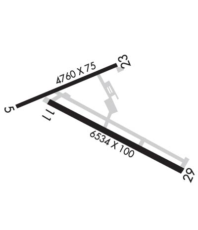
Runway Identifications
Runway Identification: 05/23Length: 4760 ft
Width: 75 ft
Surface: NATURAL SOIL-GOOD CONDITION
Edge lights: Medium IntensityTreatment: NONE
| | Runway: 05 | | Runway: 23 |
| Mag heading: | 56° | Mag heading: | 236° |
| Rwy Slope: | .26% Up | Rwy Slope: | -.26% Down |
| Approach: | | Approach: | |
| Pattern: | Left Traffic | Pattern: | Left Traffic |
| Markings: | | Markings: | |
| Marking Condition: | | Marking Condition: | |
| Arresting Dev: | | Arresting Dev: | |
| Lat & Long: | N4247.9 W10523.9 | Lat. & Long.: | N4248.2 W10522.9 |
| Elev: | 4901.6 ft. MSL | Elev: | 4913.8 ft. MSL |
| TCH: | | TCH: | 45 ft. AGL |
| Visual Glide Path: | | Visual Glide Path: | 3.00 degrees |
| Displaced Threshold: | No | Displaced Threshold: | No |
| Touchdown Zone: | YES | Touchdown Zone: | YES |
| Touchdown Elev.: | 4910.6 feet | Touchdown Elev.: | 4913.8 feet |
| Visual Glide Slope: | | Visual Glide Slope: | 2-Light PAPI on LEFT side of Runway |
| RVR Equipment: | | RVR Equipment: | |
| RVV Equipment: | NO | RVV Equipment: | NO |
| Approach Lights: | | Approach Lights: | |
| REIL: | NO | REIL: | NO |
| Centerline Lights: | NO | Centerline Lights: | NO |
| Touchdown lights: | NO | Touchdown lights: | NO |
| Runway Category: | Runway with a Visual Approach | Runway Category: | Runway with a Visual Approach |
| Declared Distances: | | Declared Distances: | |
| Obstructions: | | Obstructions: | HILL |
| Marked: | | Marked: | NOT Marked/Lighted |
| Clearance slope: | 50:1 | Clearance slope: | 23:1 |
| Obstruction height: | | Obstruction height: | 116 feet AGL |
| Dist. from runway: | | Dist. from runway: | 2925 feet |
| Centerline offset: | | Centerline offset: | 175 feet right of centerline |
| Comments: | | Comments: | |
Runway Identification: 11/29Length: 6534 ft
Width: 100 ft
Surface: ASPHALT-GOOD CONDITION
Edge lights: Medium IntensityTreatment: NONE
| | Runway: 11 | | Runway: 29 |
| Mag heading: | 107° | Mag heading: | 287° |
| Rwy Slope: | .35% Up | Rwy Slope: | -.35% Down |
| Approach: | | Approach: | |
| Pattern: | Left Traffic | Pattern: | Left Traffic |
| Markings: | NONPRECISION INSTRUMENT | Markings: | NONPRECISION INSTRUMENT |
| Marking Condition: | GOOD | Marking Condition: | GOOD |
| Arresting Dev: | | Arresting Dev: | |
| Lat & Long: | N4247.9 W10523.6 | Lat. & Long.: | N4247.4 W10522.3 |
| Elev: | 4909.6 ft. MSL | Elev: | 4932.7 ft. MSL |
| TCH: | 33 ft. AGL | TCH: | 45 ft. AGL |
| Visual Glide Path: | 3.00 degrees | Visual Glide Path: | 3.00 degrees |
| Displaced Threshold: | No | Displaced Threshold: | No |
| Touchdown Zone: | YES | Touchdown Zone: | YES |
| Touchdown Elev.: | 4920.6 feet | Touchdown Elev.: | 4932.7 feet |
| Visual Glide Slope: | 2-Light PAPI on LEFT side of Runway | Visual Glide Slope: | 2-Light PAPI on LEFT side of Runway |
| RVR Equipment: | | RVR Equipment: | |
| RVV Equipment: | NO | RVV Equipment: | NO |
| Approach Lights: | | Approach Lights: | |
| REIL: | YES | REIL: | YES |
| Centerline Lights: | NO | Centerline Lights: | NO |
| Touchdown lights: | NO | Touchdown lights: | NO |
| Runway Category: | D | Runway Category: | D |
| Declared Distances: | | Declared Distances: | |

