Click here for more info on on SMS!

KDDC

DODGE CITY RGNL
DODGE CITY
KS
Time Zone: Central
Lat: N 3745.8
Long: W 09957.9
Elev: 2596
Var: -08
Longest Runway: 6899
AWOS: 118.52
CTAF: 122.7

FBO & Flight Services info for KDDC

FBOs: Update your Fuel Prices

  click here  
Providing high quality fuel and services to you and your customers, from Phillips 66 Aviation.
Ph: 620-227-3553 Fax: 620-227-3411 Freq: 122.7WebsiteE-Mail
                                   
Service
Jet
100LL
SAF
MoGas
Fuel Avail: PRIST PREMIXED. 6A-10P, after hours fuel available with fee
Full5.095.68    Last Update: 03/26/2024 09:04

Self        
Misc. Info: JET A discount for purchase over 500 gallonsAddress: 102 AIRPORT RD,   DODGE CITY, KS 67801-9350

ASOSPh: 620-227-9721
-
Freq: 118.52  
If you are an FBO, call 1-203-262-1700 to update your info or email: FltPlan.Advertising@garmin.com
Advertise your FBO on FltPlan.com

Runway & Approach Info for KDDC
Rwy
Length
Land Dist**
Approach*
  Rwy
Length
Land Dist**
Approach*
02
4649x100  4649'          
 
  
20
  4649x100  4649'          
 
14
6899x100  6899'          
ILS
 111.70 - 146°  
  
32
  6899x100  6330'          
 
 * only ILS, LOC, LDA, and SDF approaches to a specific runway are shown
** For any Declared Landing Distance Available, please see A/FD or Approach plates
Runway Weight Capability (lbs.) Help
Runway IDSingle WheelDouble WheelDouble Tandem WheelDual Double Wheel
02/2024,000N/AN/AN/A
14/3281,000103,000168,000N/A
These numbers are Advisory and are not limits.   The Airport Manager should have more accurate Weight Limits
Approach Charts
Approaches    
Current Weather/Notams
Customs Information Send updates to Support@FltPlan.com
Customs Not Available
Database effective 04/18/2024
Airport Diagram of KDDC
Airport Diagram might not be current.

Facility Name: DODGE CITY RGNL
City Name: DODGE CITY
County: FORD
State abbrev: KS
State Name: KANSAS
   
Ownership: PUBLICLY OWNED
Use: OPEN TO THE PUBLIC
Owner's Name: CITY OF DODGE CITY
Address: PO BOX 880
 DODGE CITY, KS 67801
Owner's Phone: 620-225-8100
  
Manager's Name: MS KELLI ENLOW
Address: 100 AIRPORT RD
 DODGE CITY, KS 67801
Phone: 620-225-8100
   
FAA Region: CENTRAL
FAA Field Office: NONE


Sunrise / Sunset times for DODGE CITY RGNL

DateSunriseSunset
04/19/24 Friday6:5820:20
04/20/24 Saturday6:5720:21
04/21/24 Sunday6:5620:22
04/22/24 Monday6:5420:23
04/23/24 Tuesday6:5320:24
04/24/24 Wednesday6:5220:25
04/25/24 Thursday6:5020:26
04/26/24 Friday6:4920:26
04/27/24 Saturday6:4820:27
04/28/24 Sunday6:4720:28
04/29/24 Monday6:4620:29
04/30/24 Tuesday6:4420:30
05/01/24 Wednesday6:4320:31
05/02/24 Thursday6:4220:32

Airport Facilities

Airport Attendance Schedule7 Days A Week 0600-2200
Airport Status OPERATIONAL (This Status can change at any time - please check NOTAMS)
Airport Lighting ScheduleDUSK-DAWN. ACTVT MALSR RWY 14; REIL RWY 02/20, RWY 32; PAPI RWY 02 & 20, VASI RWY 14 & 32; MIRL RWY 14/32 & 02/20 - CTAF
Airport Storage AvailableTie Downs, Hanger
Extra Services AvailableCrop Dusting, Air Ambulance, Charter, Flight Instruction, Aircraft Rental, Aircraft Sales
Wind IndicatorYES - (lighted)
Control TowerNO
CTAF Frequency122.700
Unicom Frequency122.700
Rotating Beacon ColorWG
Segmented CircleYES
Landing FeeNO

Airport Inspection Data

Airport InspectedFEDERAL - performed by FAA AIRPORTS FIELD PERSONNEL
Inspection Date03/30/2023

Airport Services

Type of Fuel AvailableGrade 100LL, JET A (freeze point -40C)
Airframe Repair ServiceMAJOR
Power Plant Repair ServiceMAJOR

Geographic Data

LatitudeN3745.8
LongitudeW09957.9 (ESTIMATED)
Arpt Elevation2595ft (SURVEYED)
Magnetic Variation08E
3 miles Eof DODGE CITY
Traffic Pattern Altitude
Sectional ChartWICHITA

Aircraft Data

Operations (Reported)YearlyAvg. Daily
General Aviation Transient 600016
General Aviation Local 1200033
Air Taxi 15004
Commerical 450012
Commuter 00
Military 2001
Aircraft based on Field
General Aviation Singles 23
General Aviation Multi 14
Jet Aircraft 0
General Aviation Helicopters 1
Military Aircraft 0
Gliders 0
Ultralights 0

FAA Services

FSS on field NO
FSS tie-in WICHITA
FSS Phone 1-800-WX-BRIEF
Who issues Notams DDC
Notam D service at airport YES
ARTCC Name KANSAS CITY

Federal Status

Airport CertificationAIRPORT RECEIVING SCHEDULED AIR CARRIER SERVICE FROM CARRIERS CERTIFICATED BY THE CIVIL AERONAUTICS BOARD; ARFF INDEX B EQUIPMENT IS PROVIDED. 24 HRS PPR FOR UNSKED ACR OPNS WITH MORE THAN 30 PASSENGER SEATS; CALL FORD COUNTY COMMUNICATIONS AT 620-227-4646.
Aircraft Rescue & Firefighting IndexAIRPORT HAS A CERTIFICATE UNDER CFR PART 139
Airport of EntryNo
Custom Landing RightsNo
Joint Civil/MilitaryNo
Military Landing rightsYES

Federal Agreements

NATIONAL PLAN OF INTEGRATED AIRPORT SYSTEMS (NPIAS)
GRANT AGREEMENTS UNDER FAAP/ADAP/AIP
ASSURANCES PURSUANT TO TITLE VI, CIVIL RIGHTS ACT OF 1964
AGREEMENT UNDER DLAND OR DCLA HAS EXPIRED.

Remarks

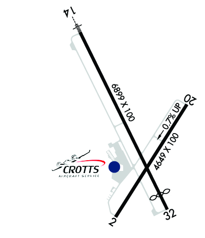
DUE TO RY CROWNING, APCH ENDS OF RY 02 AND RY 20 ARE NOT VISIBLE FROM THE OPPOSITE END OF THE RUNWAY.
FOR CD IF UNA TO CTC ON FSS FREQ, CTC KANSAS CITY ARTCC AT 913-254-8508.
Airport Communications & Frequencies:
CTAF Frequency:
122.700
Unicom Frequency:
122.700
Remarks
  • APCH/DEP CTL SVC PRVDD BY KANSAS CITY ARTCC (ZKC) ON FREQS 125.2/285.425 (GARDEN CITY RCAG).
  • Runway Identifications
    Runway Identification: 02/20
    Length: 4649 ft
    Width: 100 ft
    Surface: ASPHALT-FAIR CONDITION
    Edge lights: Medium Intensity

    Treatment: NONE
    Weight: PCN 9 /F/D/X/T

     Runway: 02   Runway: 20
    Mag heading: 24°Mag heading: 204°
    Rwy Slope: -.67% DownRwy Slope: .67% Up
    Approach: Approach:
    Pattern: Left TrafficPattern: Left Traffic
    Markings: NONPRECISION INSTRUMENTMarkings: NONPRECISION INSTRUMENT
    Marking Condition: FAIRMarking Condition: FAIR
    Arresting Dev: Arresting Dev:
    Lat & Long: N3745.3  W09958.1Lat. & Long.: N3746.0  W09957.5
    Elev: 2595.0 ft. MSLElev: 2563.8 ft. MSL
    TCH: 37 ft. AGLTCH: 45 ft. AGL
    Visual Glide Path: 3.00 degreesVisual Glide Path: 3.00 degrees
    Displaced Threshold: NoDisplaced Threshold: No
    Touchdown Zone: YESTouchdown Zone: YES
    Touchdown Elev.: 2595.5 feetTouchdown Elev.: 2592.3 feet
    Visual Glide Slope: 4-Light PAPI on LEFT side of RunwayVisual Glide Slope: 4-Light PAPI on LEFT side of Runway
    RVR Equipment: RVR Equipment:
    RVV Equipment: NORVV Equipment: NO
    Approach Lights: Approach Lights:
    REIL: YESREIL: YES
    Centerline Lights: NOCenterline Lights: NO
    Touchdown lights: NOTouchdown lights: NO
    Runway Category: Runway with a Non-precision Approach having visibility minimums greater than 3/4 mileRunway Category: Runway with a Non-precision Approach having visibility minimums greater than 3/4 mile
    Declared Distances: TORA:4649' TODA:4649' ASDA:4649' LDA:4649'Declared Distances: TORA:4649' TODA:4649' ASDA:4649' LDA:4649'
    Runway Identification: 14/32
    Length: 6899 ft
    Width: 100 ft
    Surface: ASPHALT-FAIR CONDITION
    Edge lights: Medium Intensity

    Treatment: NONE
    Weight: PCN 32 /F/D/X/T

     Runway: 14   Runway: 32
    Mag heading: 146°Mag heading: 326°
    Rwy Slope: .05% UpRwy Slope: -.05% Down
    Approach: ILSApproach:
    Pattern: Left TrafficPattern: Left Traffic
    Markings: PRECISION INSTRUMENTMarkings: PRECISION INSTRUMENT
    Marking Condition: GOODMarking Condition: GOOD
    Arresting Dev: Arresting Dev:
    Lat & Long: N3746.4  W09958.3Lat. & Long.: N3745.4  W09957.7
    Elev: 2582.8 ft. MSLElev: 2586.5 ft. MSL
    TCH: 55 ft. AGLTCH: 40 ft. AGL
    Visual Glide Path: 3.00 degreesVisual Glide Path: 3.00 degrees
    Displaced Threshold: NoDisplaced Threshold: 569 feet
    Touchdown Zone: YESTouchdown Zone: YES
    Touchdown Elev.: 2585.7 feetTouchdown Elev.: 2591.1 feet
    Visual Glide Slope: 4-BOX VASI ON LEFT SIDE OF RUNWAYVisual Glide Slope: 4-BOX VASI ON LEFT SIDE OF RUNWAY
    RVR Equipment: RVR Equipment:
    RVV Equipment: NORVV Equipment: NO
    Approach Lights: MALSR - 1,400 foot medium intensity approach lighting system with runway alignment indicator lightsApproach Lights:
    REIL: NOREIL: YES
    Centerline Lights: NOCenterline Lights: NO
    Touchdown lights: NOTouchdown lights: NO
    Runway Category: Precision Instrument RunwayRunway Category: D
    Declared Distances: TORA:6899' TODA:6899' ASDA:6329' LDA:6329'Declared Distances: TORA:6899' TODA:6899' ASDA:6899' LDA:6329'
    C:42/P: