Current Weather/Notams (Metars, TAFs, Notams, NWS Forecast, PIREPS, and nearby weather)
Customs Information Send updates to Support@FltPlan.com
Customs Not Available
Database effective 05/16/2024
Airport Diagram might not be current.
|
| Facility Name: | CHESTER CATAWBA RGNL |
| City Name: | CHESTER |
| County: | CHESTER |
| State abbrev: | SC |
| State Name: | SOUTH CAROLINA |
| | |
| Ownership: | PUBLICLY OWNED |
| Use: | OPEN TO THE PUBLIC |
| Owner's Name: | COUNTY OF CHESTER |
| Address: | P.O. BOX 594 |
| | CHESTER, SC 29706 |
| Owner's Phone: | (803) 385-3154 |
| | |
| Manager's Name: | KEITH ROACH; ARPT CAN BE ACESD BY PEDESTRIAN GATE NEXT TO TRML BLDG AFT HRS BY FIRST FOUR NRS OF AWOS FREQ IN COMBINATION LOCK BOX. |
| Address: | 1854-A, PIPER DR. |
| | CHESTER, SC 29706 |
| Phone: | 803-385-6664 |
| | |
| FAA Region: | SOUTHERN |
| FAA Field Office: | ATL |
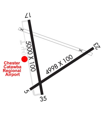
Runway Identifications
Runway Identification: 05/23Length: 4998 ft
Width: 100 ft
Surface: ASPHALT-POOR CONDITION
Edge lights: Treatment: NONE
| | Runway: 05 | | Runway: 23 |
| Mag heading: | 61° | Mag heading: | 241° |
| Rwy Slope: | -.43% Down | Rwy Slope: | .43% Up |
| Approach: | | Approach: | |
| Pattern: | Right Traffic | Pattern: | Left Traffic |
| Markings: | BASIC | Markings: | BASIC |
| Marking Condition: | GOOD | Marking Condition: | GOOD |
| Arresting Dev: | | Arresting Dev: | |
| Lat & Long: | N3447.1 W08112.0 | Lat. & Long.: | N3447.5 W08111.2 |
| Elev: | 641.7 ft. MSL | Elev: | 620.3 ft. MSL |
| TCH: | | TCH: | |
| Visual Glide Path: | | Visual Glide Path: | |
| Displaced Threshold: | 949 feet | Displaced Threshold: | No |
| Touchdown Zone: | YES | Touchdown Zone: | YES |
| Touchdown Elev.: | 641.7 feet | Touchdown Elev.: | 633.8 feet |
| Visual Glide Slope: | | Visual Glide Slope: | |
| RVR Equipment: | | RVR Equipment: | |
| RVV Equipment: | NO | RVV Equipment: | NO |
| Approach Lights: | | Approach Lights: | |
| REIL: | NO | REIL: | NO |
| Centerline Lights: | NO | Centerline Lights: | NO |
| Touchdown lights: | NO | Touchdown lights: | NO |
| Runway Category: | Runway with a Visual Approach | Runway Category: | Runway with a Visual Approach |
| Declared Distances: | | Declared Distances: | |
| Obstructions: | TREE | Obstructions: | TREE |
| Marked: | NOT Marked/Lighted | Marked: | NOT Marked/Lighted |
| Clearance slope: | 16:1 | Clearance slope: | 5:1 |
| Obstruction height: | 76 feet AGL | Obstruction height: | 22 feet AGL |
| Dist. from runway: | 1433 feet | Dist. from runway: | 310 feet |
| Centerline offset: | 223 left of centerline | Centerline offset: | 86 feet right of centerline |
| Comments: | | Comments: | |
Runway Identification: 17/35Length: 5000 ft
Width: 100 ft
Surface: ASPHALT-FAIR CONDITION
Edge lights: Medium IntensityTreatment: NONE
| | Runway: 17 | | Runway: 35 |
| Mag heading: | 174° | Mag heading: | 354° |
| Rwy Slope: | -.41% Down | Rwy Slope: | .41% Up |
| Approach: | | Approach: | |
| Pattern: | Right Traffic | Pattern: | Left Traffic |
| Markings: | NONPRECISION INSTRUMENT | Markings: | NONPRECISION INSTRUMENT |
| Marking Condition: | FAIR | Marking Condition: | FAIR |
| Arresting Dev: | | Arresting Dev: | |
| Lat & Long: | N3447.8 W08112.0 | Lat. & Long.: | N3447.0 W08111.8 |
| Elev: | 656.6 ft. MSL | Elev: | 636.1 ft. MSL |
| TCH: | 26 ft. AGL | TCH: | 32 ft. AGL |
| Visual Glide Path: | 3.00 degrees | Visual Glide Path: | 3.00 degrees |
| Displaced Threshold: | No | Displaced Threshold: | No |
| Touchdown Zone: | YES | Touchdown Zone: | YES |
| Touchdown Elev.: | 656.6 feet | Touchdown Elev.: | 648.2 feet |
| Visual Glide Slope: | 2-Light PAPI on LEFT side of Runway | Visual Glide Slope: | 2-Light PAPI on LEFT side of Runway |
| RVR Equipment: | | RVR Equipment: | |
| RVV Equipment: | NO | RVV Equipment: | NO |
| Approach Lights: | | Approach Lights: | |
| REIL: | NO | REIL: | NO |
| Centerline Lights: | NO | Centerline Lights: | NO |
| Touchdown lights: | NO | Touchdown lights: | NO |
| Runway Category: | Runway with a Non-precision Approach having visibility minimums greater than 3/4 mile | Runway Category: | Runway with a Non-precision Approach having visibility minimums greater than 3/4 mile |
| Declared Distances: | | Declared Distances: | |
| Obstructions: | TREE | Obstructions: | TREE |
| Marked: | NOT Marked/Lighted | Marked: | NOT Marked/Lighted |
| Clearance slope: | 16:1 | Clearance slope: | 32:1 |
| Obstruction height: | 36 feet AGL | Obstruction height: | 38 feet AGL |
| Dist. from runway: | 779 feet | Dist. from runway: | 1426 feet |
| Centerline offset: | 140 right of centerline | Centerline offset: | 180 feet left of centerline |
| Comments: | | Comments: | |