Sunrise / Sunset times for RONALD REAGAN WASHINGTON NTL
Date
Sunrise
Sunset
04/25/24 Thursday
6:17
19:56
04/26/24 Friday
6:16
19:57
04/27/24 Saturday
6:14
19:58
04/28/24 Sunday
6:13
19:58
04/29/24 Monday
6:12
19:59
04/30/24 Tuesday
6:11
20:00
05/01/24 Wednesday
6:10
20:01
05/02/24 Thursday
6:08
20:02
05/03/24 Friday
6:07
20:03
05/04/24 Saturday
6:06
20:04
05/05/24 Sunday
6:05
20:05
05/06/24 Monday
6:04
20:06
05/07/24 Tuesday
6:03
20:07
05/08/24 Wednesday
6:02
20:08
Airport Facilities
Airport Attendance Schedule
CONTINUOUS
Airport Status
OPERATIONAL (This Status can change at any time - please check NOTAMS)
Airport Lighting Schedule
Airport Storage Available
Tie Downs, Hanger
Extra Services Available
Cargo Handling
Wind Indicator
YES - (lighted)
Control Tower
YES
CTAF Frequency
Unicom Frequency
122.950
Rotating Beacon Color
WG
Segmented Circle
NO
Landing Fee
YES
Airport Inspection Data
Airport Inspected
FEDERAL - performed by FAA AIRPORTS FIELD PERSONNEL
Inspection Date
03/13/2023
Airport Services
Type of Fuel Available
JET A (freeze point -40C)
Airframe Repair Service
MINOR
Power Plant Repair Service
MINOR
Geographic Data
Latitude
N3851.1
Longitude
W07702.3 (ESTIMATED)
Arpt Elevation
14ft (SURVEYED)
Magnetic Variation
11W
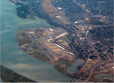
3 miles S
of WASHINGTON
Traffic Pattern Altitude
Sectional Chart
WASHINGTON
Aircraft Data
Operations (Reported)
Yearly
Avg. Daily
General Aviation Transient
1928
5
General Aviation Local
0
0
Air Taxi
85
0
Commerical
294410
807
Commuter
0
0
Military
1022
3
Aircraft based on Field
General Aviation Singles
0
General Aviation Multi
0
Jet Aircraft
0
General Aviation Helicopters
0
Military Aircraft
0
Gliders
0
Ultralights
0
FAA Services
FSS on field
NO
FSS tie-in
LEESBURG
FSS Phone
1-800-WX-BRIEF
Who issues Notams
DCA
Notam D service at airport
YES
ARTCC Name
WASHINGTON
Federal Status
Airport Certification
AIRPORT RECEIVING SCHEDULED AIR CARRIER SERVICE FROM CARRIERS CERTIFICATED BY THE CIVIL AERONAUTICS BOARD
Aircraft Rescue & Firefighting Index
AIRPORT HAS A CERTIFICATE UNDER CFR PART 139
Airport of Entry
No
Custom Landing Rights
YES
Joint Civil/Military
No
Military Landing rights
No
Federal Agreements
NATIONAL PLAN OF INTEGRATED AIRPORT SYSTEMS (NPIAS)
GRANT AGREEMENTS UNDER FAAP/ADAP/AIP
OBLIGATIONS ASSUMED BY TRANSFER
ASSURANCES PURSUANT TO TITLE VI, CIVIL RIGHTS ACT OF 1964
COMPLIANCE WITH ACCESSIBILITY TO THE HANDICAPPED
Remarks
TWY K ENDS AT GATE 5.
FLOCKS OF BIRDS ON & INVOF ARPT; FQT GULL & GEESE & DUCK POPULATIONS AB OVER ADJ RIVER AREAS.
TRNG FLIGHTS THAT INCLUDE MULTIPLE APCHS AND/OR TOUCH & GO OPNS REQUIRE PRIOR PERMISSION FM THE ARPT MGR.
LEFT-HAND TURN-OFFS FROM RWY 33 TO TWY 'K' PROHIBITED.
ACFT ARRIVING/DEPARTING THE GA PARKING AREA ARE PROHIBITED FM TAXING BTN ACR PUSHBACK OPNS & THE GATES.
BE ADVISED SOME AIRCREWS MISTAKE RWY 15 FOR RWY 19.
ASDE-X IN USE. OPERATE TRANSPONDERS WITH ALTITUDE REPORTING MODE AND ADS-B (IF EQUIPPED) ENABLED ON ALL AIRPORT SURFACES.
RONALD REAGAN WASHINGTON NATIONAL ARPRT (KDCA) IS AN EMERGENCY USE ONLY FIELD FOR ALL DOD OWNED AND OPERATED ACFT.
TWY N BTN APCH END RWY 15 AND TWY K CLSD TO ACFT WINGSPAN MORE THAN 124FT.
LGT FM VEHICLE PARKING LOT LCTD 1000 FT SW OF RWY 01 COULD GIVE FALSE INDICATIONS OF BEING PART OF RWY 01 APCH LGT SYS DRG PERIODS OF REDUCED VIS & LOW CEILINGS.
FORM 150R CREDIT CARD FOR ALL RQRD SVCS. NO MIL FACS.
RWY 19X THIS RWY EXISTS TO SUPPORT THE DCA LDA ASSOCIATED WITH THE ILS.
Airport Communications & Frequencies:
ATIS Frequencies: Hours(local) of Operation: CONTINUOUS
132.65
WASHINGTON Tower Frequencies: Hours(local) of operation: CONTINUOUS
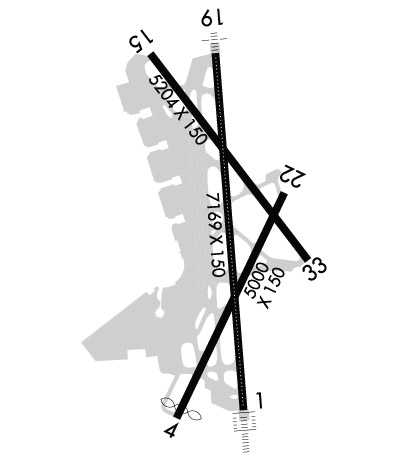
Length: 7169 ft Width: 150 ft Surface: ASPHALT-GOOD CONDITION Edge lights: High Intensity Treatment: GROOVED Weight: PCN 57 /F/B/X/T
Runway: 01
Runway: 19
Mag heading:
7°
Mag heading:
186°
Rwy Slope:
.01% Up
Rwy Slope:
-.01% Down
Approach:
ILS/DME
Approach:
LDA/DME
Pattern:
Left Traffic
Pattern:
Right Traffic
Markings:
PRECISION INSTRUMENT
Markings:
PRECISION INSTRUMENT
Marking Condition:
GOOD
Marking Condition:
GOOD
Arresting Dev:
Arresting Dev:
Lat & Long:
N3850.5 W07702.2
Lat. & Long.:
N3851.7 W07702.3
Elev:
11.4 ft. MSL
Elev:
12.1 ft. MSL
TCH:
54 ft. AGL
TCH:
50 ft. AGL
Visual Glide Path:
3.00 degrees
Visual Glide Path:
3.00 degrees
Displaced Threshold:
No
Displaced Threshold:
No
Touchdown Zone:
YES
Touchdown Zone:
YES
Touchdown Elev.:
13.9 feet
Touchdown Elev.:
13.1 feet
Visual Glide Slope:
4-Light PAPI on RIGHT side of Runway
Visual Glide Slope:
4-Light PAPI on LEFT side of Runway; RWY 19 PAPI-4L CONSISTS OF TWO PAPI-4L SYSTEMS. RWY 19 PAPI-4L IS ROTATED 21 DEGS TO RIGHT OF CNTRLN. THE ROTATED PAPI-4L SYSTEM SUPPORTS VISUAL AND INSTR APCHS TO RWY 19.
RVR Equipment:
TOUCHDOWN-ROLLOUT
RVR Equipment:
TOUCHDOWN-ROLLOUT
RVV Equipment:
NO
RVV Equipment:
NO
Approach Lights:
ALSF2 - standard 2,400 foot high intensity approach lighting system with sequenced flashers, Category II or III
Approach Lights:
MALSF - 1,400 foot medium intensity approach lighting system with sequenced flashers
REIL:
NO
REIL:
NO
Centerline Lights:
YES
Centerline Lights:
YES
Touchdown lights:
YES
Touchdown lights:
NO
Runway Category:
Precision Instrument Runway
Runway Category:
Runway with a Non-precision Approach having visibility minimums greater than 3/4 mile
Declared Distances:
TORA:6869' TODA:6869' ASDA:6869' LDA:6869'
Declared Distances:
TORA:6869' TODA:6869' ASDA:6869' LDA:6869'
Obstructions:
TOWER
Obstructions:
TREE
Marked:
LIGHTED
Marked:
NOT Marked/Lighted
Clearance slope:
41:1
Clearance slope:
29:1
Obstruction height:
180 feet AGL
Obstruction height:
27 feet AGL
Dist. from runway:
7700 feet
Dist. from runway:
990 feet
Centerline offset:
1600 left of centerline
Centerline offset:
240 feet left of centerline
Comments:
Comments:
+10 FT BLDG (L/M) +120 FT FROM AER 300 FT LEFT.
Runway Identification: 04/22
Length: 5000 ft Width: 150 ft Surface: ASPHALT-GOOD CONDITION Edge lights: Medium Intensity Treatment: GROOVED Weight: PCN 57 /F/B/X/T
Runway: 04
Runway: 22
Mag heading:
37°
Mag heading:
217°
Rwy Slope:
-.01% Down
Rwy Slope:
.01% Up
Approach:
Approach:
Pattern:
Left Traffic
Pattern:
Right Traffic
Markings:
NONPRECISION INSTRUMENT
Markings:
NONPRECISION INSTRUMENT
Marking Condition:
GOOD
Marking Condition:
GOOD
Arresting Dev:
EMAS; ENGINEERED MATERIALS ARRESTING SYSTEM (EMAS) 336 FT IN LENGTH BY 170 FT IN WIDTH LCTD AT THE DER 04.
Arresting Dev:
Lat & Long:
N3850.5 W07702.5
Lat. & Long.:
N3851.2 W07702.0
Elev:
11.4 ft. MSL
Elev:
11.0 ft. MSL
TCH:
52 ft. AGL
TCH:
45 ft. AGL
Visual Glide Path:
3.25 degrees
Visual Glide Path:
3.00 degrees
Displaced Threshold:
200 feet
Displaced Threshold:
No
Touchdown Zone:
YES
Touchdown Zone:
YES
Touchdown Elev.:
13.7 feet
Touchdown Elev.:
13.7 feet
Visual Glide Slope:
4-Light PAPI on LEFT side of Runway
Visual Glide Slope:
4-Light PAPI on LEFT side of Runway
RVR Equipment:
RVR Equipment:
RVV Equipment:
NO
RVV Equipment:
NO
Approach Lights:
Approach Lights:
REIL:
YES
REIL:
YES
Centerline Lights:
NO
Centerline Lights:
NO
Touchdown lights:
NO
Touchdown lights:
NO
Runway Category:
Runway with a Visual Approach
Runway Category:
Runway with a Visual Approach
Declared Distances:
TORA:5000' TODA:5000' ASDA:5000' LDA:4800'
Declared Distances:
TORA:4540' TODA:4540' ASDA:4400' LDA:4400'
Obstructions:
ROAD
Obstructions:
GND
Marked:
LIGHTED
Marked:
NOT Marked/Lighted
Clearance slope:
20:1
Clearance slope:
10:1
Obstruction height:
10 feet AGL
Obstruction height:
2 feet AGL
Dist. from runway:
400 feet
Dist. from runway:
220 feet
Centerline offset:
500 left of centerline; THREE OBSTRUCTION LGTS POLES--ONE 600 FEET LEFT, ONE ON CENTERLINE, ONE 600 FEET RIGHT.
Centerline offset:
Comments:
Comments:
Runway Identification: 15/33
Length: 5204 ft Width: 150 ft Surface: ASPHALT Edge lights: High Intensity Treatment: GROOVED Weight: PCN 57 /F/B/X/T
Runway: 15
Runway: 33
Mag heading:
154°
Mag heading:
334°
Rwy Slope:
-.07% Down
Rwy Slope:
.07% Up
Approach:
Approach:
Pattern:
Right Traffic
Pattern:
Left Traffic
Markings:
NONPRECISION INSTRUMENT
Markings:
NONPRECISION INSTRUMENT
Marking Condition:
GOOD
Marking Condition:
GOOD
Arresting Dev:
EMAS; ENGINEERED MATERIALS ARRESTING SYSTEM (EMAS) 142 FT IN LENGTH BY 170 FT IN WIDTH LCTD AT THE DER 15.
Arresting Dev:
EMAS; ENGINEERED MATERIALS ARRESTING SYSTEM (EMAS) 332 FT IN LENGTH BY 170 FT IN WIDTH LCTD AT THE DER 33.
Lat & Long:
N3851.7 W07702.6
Lat. & Long.:
N3851.0 W07701.9
Elev:
14.0 ft. MSL
Elev:
10.3 ft. MSL
TCH:
36 ft. AGL
TCH:
37 ft. AGL
Visual Glide Path:
3.00 degrees
Visual Glide Path:
3.00 degrees
Displaced Threshold:
No
Displaced Threshold:
No
Touchdown Zone:
YES
Touchdown Zone:
YES
Touchdown Elev.:
14.1 feet
Touchdown Elev.:
12.5 feet
Visual Glide Slope:
4-Light PAPI on LEFT side of Runway
Visual Glide Slope:
4-Light PAPI on LEFT side of Runway
RVR Equipment:
RVR Equipment:
RVV Equipment:
NO
RVV Equipment:
NO
Approach Lights:
Approach Lights:
REIL:
YES
REIL:
YES
Centerline Lights:
NO
Centerline Lights:
NO
Touchdown lights:
NO
Touchdown lights:
NO
Runway Category:
Runway with a Non-precision Approach having visibility minimums greater than 3/4 mile
Runway Category:
Runway with a Non-precision Approach having visibility minimums greater than 3/4 mile
Declared Distances:
TORA:5204' TODA:5204' ASDA:5204' LDA:5204'
Declared Distances:
TORA:5204' TODA:5204' ASDA:5204' LDA:5204'
Obstructions:
TREES
Obstructions:
TREES
Marked:
LIGHTED
Marked:
NOT Marked/Lighted
Clearance slope:
3:1
Clearance slope:
37:1
Obstruction height:
49 feet AGL
Obstruction height:
253 feet AGL
Dist. from runway:
380 feet
Dist. from runway:
9600 feet
Centerline offset:
510 right of centerline
Centerline offset:
Comments:
RWY 15 +8 FT BLAST FENCE 120 FT FM AER 250 FT RIGHT.