Click here for more info on on SMS!

KDAF

NECEDAH
NECEDAH
WI
Time Zone: Central
Lat: N 4402.0
Long: W 09005.1
Elev: 919
Var: +01
Longest Runway: 2721
CTAF: 122.7

FBO & Flight Services info for KDAF

FBOs: Update your Fuel Prices

NECEDAHPh: 608-565-3900
-
Freq: 122.7
Service
Jet
100LL
SAF
MoGas
Fuel Avail: NO FUEL AVAILABLE
Full        Last Update: 04/25/2024 05:27:33

Self        
If you are an FBO, call 1-203-262-1700 to update your info or email: FltPlan.Advertising@garmin.com
Advertise your FBO on FltPlan.com

Runway & Approach Info for KDAF
Rwy
Length
Land Dist**
Approach*
  Rwy
Length
Land Dist**
Approach*
18
2721x60  2721'          
 
  
36
  2721x60  2721'          
 
 * only ILS, LOC, LDA, and SDF approaches to a specific runway are shown
** For any Declared Landing Distance Available, please see A/FD or Approach plates
Runway Weight Capability (lbs.) Help
Runway IDSingle WheelDouble WheelDouble Tandem WheelDual Double Wheel
18/36N/AN/AN/AN/A
These numbers are Advisory and are not limits.   The Airport Manager should have more accurate Weight Limits
Approach Charts
Approaches    
Current Weather/Notams
Customs Information Send updates to Support@FltPlan.com
Customs Not Available
Database effective 05/16/2024
Airport Diagram of KDAF
Airport Diagram might not be current.

Facility Name: NECEDAH
City Name: NECEDAH
County: JUNEAU
State abbrev: WI
State Name: WISCONSIN
   
Ownership: PUBLICLY OWNED
Use: OPEN TO THE PUBLIC
Owner's Name: VILLAGE OF NECEDAH
Address: VILLAGE HALL
 NECEDAH, WI 54646
Owner's Phone: 608-565-2261; EXT 2
  
Manager's Name: JACK JASINSKI
Address: W6827 20TH STREET W; EMAIL ADDRESS: NECEDAHADMIN@NECEDAH.US (ALL LOWER CASE)
 NECEDAH, WI 54646
Phone: 608-547-3411
   
FAA Region: GREAT LAKES
FAA Field Office: CHI


Sunrise / Sunset times for NECEDAH

DateSunriseSunset
04/24/24 Wednesday6:0119:56
04/25/24 Thursday6:0019:57
04/26/24 Friday5:5819:59
04/27/24 Saturday5:5720:00
04/28/24 Sunday5:5520:01
04/29/24 Monday5:5420:02
04/30/24 Tuesday5:5220:03
05/01/24 Wednesday5:5120:05
05/02/24 Thursday5:4920:06
05/03/24 Friday5:4820:07
05/04/24 Saturday5:4720:08
05/05/24 Sunday5:4520:09
05/06/24 Monday5:4420:10
05/07/24 Tuesday5:4320:12

Airport Facilities

Airport Attendance ScheduleUNATTENDED
Airport Status OPERATIONAL (This Status can change at any time - please check NOTAMS)
Airport Lighting ScheduleACTVT LIRL RY 18/36 - CTAF.
Airport Storage AvailableTie Downs
Extra Services AvailableNONE
Wind IndicatorYES - (lighted)
Control TowerNO
CTAF Frequency122.700
Unicom Frequency122.700
Rotating Beacon ColorWG
Segmented CircleYES
Landing FeeNO

Airport Inspection Data

Airport InspectedSTATE - performed by STATE AERONAUTICAL PERSONNEL
Inspection Date06/29/2022

Airport Services

Type of Fuel AvailableNone
Airframe Repair ServiceMINOR
Power Plant Repair ServiceMINOR

Geographic Data

LatitudeN4402.0
LongitudeW09005.1 (ESTIMATED)
Arpt Elevation919ft (SURVEYED)
Magnetic Variation01W
1 miles NWof NECEDAH
Traffic Pattern Altitude
Sectional ChartGREEN BAY

Aircraft Data

Operations (Reported)YearlyAvg. Daily
General Aviation Transient 34009
General Aviation Local 550015
Air Taxi 500
Commerical 00
Commuter 00
Military 00
Aircraft based on Field
General Aviation Singles 9
General Aviation Multi 0
Jet Aircraft 0
General Aviation Helicopters 0
Military Aircraft 0
Gliders 0
Ultralights 0

FAA Services

FSS on field NO
FSS tie-in GREEN BAY
FSS Phone 1-800-WX-BRIEF
Who issues Notams GRB
Notam D service at airport YES
ARTCC Name CHICAGO

Federal Status

Airport Certification
Aircraft Rescue & Firefighting IndexNone
Airport of EntryNo
Custom Landing RightsNo
Joint Civil/MilitaryNo
Military Landing rightsNo

Remarks

DURG WINTER MONTHS CALL 608-547-3411 BFR LNDG TO DTRM STATUS.
FOR CD CTC CHICAGO ARTCC AT 630-906-8921.
Airport Communications & Frequencies:
CTAF Frequency:
122.700
Unicom Frequency:
122.700
Remarks
  • APCH/DEP SVC PRVDD BY CHICAGO ARTCC (ZAU) ON FREQS 125.05/269.375 (CAMP DOUGLAS RCAG) WHEN VOLK APCH CTL CLSD.
  • VOLK Primary Approach Frequencies:  
    135.25
    244.875
    VOLK Primary Departure Frequencies:  
    135.25
    244.875
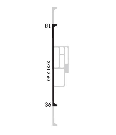
    Runway Identifications
    Runway Identification: 18/36
    Length: 2721 ft
    Width: 60 ft
    Surface: ASPHALT-FAIR CONDITION
    Edge lights: Low Intensity

    Treatment: NONE

     Runway: 18   Runway: 36
    Mag heading: 180°Mag heading: 360°
    Rwy Slope: .27% UpRwy Slope: -.27% Down
    Approach: Approach:
    Pattern: Left TrafficPattern: Left Traffic
    Markings: NONPRECISION INSTRUMENTMarkings: NONPRECISION INSTRUMENT
    Marking Condition: GOODMarking Condition: GOOD
    Arresting Dev: Arresting Dev:
    Lat & Long: N4402.2  W09005.1Lat. & Long.: N4401.8  W09005.1
    Elev: 912.0 ft. MSLElev: 919.3 ft. MSL
    TCH: TCH:
    Visual Glide Path: Visual Glide Path:
    Displaced Threshold: NoDisplaced Threshold: No
    Touchdown Zone: YESTouchdown Zone: YES
    Touchdown Elev.: 919.3 feetTouchdown Elev.: 919.3 feet
    Visual Glide Slope: Visual Glide Slope:
    RVR Equipment: RVR Equipment:
    RVV Equipment: NORVV Equipment: NO
    Approach Lights: Approach Lights:
    REIL: NOREIL: NO
    Centerline Lights: NOCenterline Lights: NO
    Touchdown lights: NOTouchdown lights: NO
    Runway Category: Runway with a Visual ApproachRunway Category: Runway with a Non-precision Approach
    Declared Distances: Declared Distances:
    Obstructions: TREESObstructions: ROAD
    Marked: NOT Marked/LightedMarked: NOT Marked/Lighted
    Clearance slope: 1:1Clearance slope: 7:1
    Obstruction height: 35 feet AGLObstruction height: 15 feet AGL
    Dist. from runway: 200 feetDist. from runway: 307 feet
    Centerline offset: 250 left of centerlineCenterline offset: 264 feet left of centerline
    Comments: 35 FT TREES 0 - 200 FT FM RWY END, 237 FT L.Comments:
    C:/P: