KDAB

DAYTONA BEACH INTL
DAYTONA BEACH
FL
Time Zone: Eastern
Lat: N 2910.8
Long: W 08103.5
Elev: 34
Var: +05
Longest Runway: 10500
Clr Del: 119.3
Dept. ATIS: 132.87
Arr. ATIS: 132.87
Ground: 121.9
Tower: 120.7

FBO & Flight Services info for KDAB

FBOs: Update your Fuel Prices

  click here  
The Premier FBO at Daytona Beach with the shortest taxi time to & from the main runway. First rate pilot lounge, spacious & comfortable customer lobby, executive conference room, wireless Internet, fully equipped kitchen, crew car, full service fueling, self-service fuel farms, GPUs-no charge, lav service, overnight or permanent hangar facilities, aircraft maintenance & executive charter services.
Ph: 888-322-5382 Fax: 386-257-1391 Freq: 129.7WebsiteE-Mail
                     
Service
Jet
100LL
SAF
MoGas
Fuel Avail: PRIST+ $0.11/gal. Mon-Fri 08:00-19:00 Sat/Sun 09:00-18:00 call for afterhour services.
Full6.167.65    Last Update: 04/02/2024 10:41

Self        
Misc. Info: Address: 2326 BELLEVUE AVE EXT.   DAYTONA BEACH, FL 32114

SHELTAIR AVIATIONPh: 386-255-0471 Fax: 386-253-8552 Freq: 130.1
Service
Jet
100LL
SAF
MoGas
Fuel Avail: PRIST +$0.08/gal. 0600-2100 (365 days a yr) Call for after hrs service & fees
Full6.047.65    Last Update: 03/30/2024 13:25  
Self        
 Address: 563 PEARL HARBOR DR.   DAYTONA BEACH, FL 32114
ATP JET CENTERPh: 386-385-8880 Fax: 386-252-6082 Freq: 122.95
Service
Jet
100LL
SAF
MoGas
Fuel Avail: VOLUME DISC AVAIL.Self Serve 100LL 24 hours Full Service 0730 to 2000 Weekdays 0730 to 1800 Weekends
Full5.735.95    Last Update: 04/23/2024 13:12  
Self  5.75    
 Address: 1624 AVIATION CENTER PARKWAY   DAYTONA BEACH, FL 32114
AOG MXPh: 386-566-4821
-
-
Service
Jet
100LL
SAF
MoGas
Fuel Avail: ~~No fuel. Maintenance - Specializing in general aviation, full-service.
Full        Last Update: 04/25/2024 05:27:31  
Self        
 Address: 1585 AVIATION CENTER PARKWAY, SUITE 900   DAYTONA BEACH, FL 32114
ASOSPh: 386-253-7469
-
-
 
If you are an FBO, call 1-203-262-1700 to update your info or email: FltPlan.Advertising@garmin.com
Advertise your FBO on FltPlan.com

Runway & Approach Info for KDAB
Rwy
Length
Land Dist**
Approach*
  Rwy
Length
Land Dist**
Approach*
07L
10500x150  9810'          
LOC/GS
 109.70 - 070°  
  
25R
  10500x150  10500'          
ILS/DME
 109.70 - 250°  
07R
3195x100  3195'          
 
  
25L
  3195x100  3195'          
 
16
6001x150  6001'          
 
  
34
  6001x150  6001'          
 
 * only ILS, LOC, LDA, and SDF approaches to a specific runway are shown
** For any Declared Landing Distance Available, please see A/FD or Approach plates
Runway Weight Capability (lbs.) Help
Runway IDSingle WheelDouble WheelDouble Tandem WheelDual Double Wheel
07L/25R120,000224,000402,000915,000
07R/25L24,00038,500N/AN/A
16/34120,000225,000385,000892,000
These numbers are Advisory and are not limits.   The Airport Manager should have more accurate Weight Limits
Approach Charts
Approaches    
Current Weather/Notams
Customs Information Send updates to Support@FltPlan.com
Phone 386-248-8043
Fax N/A

Comments Mon-Fri 0900-1730 *2 hour advance notice required *Maximum passengers per flight: 20 *Call prior to 1700 on preceding weekday. *Prior approval required (landing rights and overflight). Weekend arrivals call prior to 1600 on preceding Friday and after hours.
Database effective 05/16/2024
Airport Diagram of KDAB
Airport Diagram might not be current.

Facility Name: DAYTONA BEACH INTL
City Name: DAYTONA BEACH
County: VOLUSIA
State abbrev: FL
State Name: FLORIDA
   
Ownership: PUBLICLY OWNED
Use: OPEN TO THE PUBLIC
Owner's Name: VOLUSIA COUNTY
Address: 123 W INDIANA AVE
 DELAND, FL 32720-4612
Owner's Phone: 386-248-8030
  
Manager's Name: MS KAREN K FEASTER, AAE, IACE, ACE
Address: 700 CATALINA DR, SUITE 300, DAYTONA BEACH INTL ARPT
 DAYTONA BEACH, FL 32114
Phone: 386-248-8030
   
FAA Region: SOUTHERN
FAA Field Office: ORL


Sunrise / Sunset times for DAYTONA BEACH INTL

DateSunriseSunset
04/24/24 Wednesday6:4819:57
04/25/24 Thursday6:4719:57
04/26/24 Friday6:4619:58
04/27/24 Saturday6:4519:58
04/28/24 Sunday6:4519:59
04/29/24 Monday6:4420:00
04/30/24 Tuesday6:4320:00
05/01/24 Wednesday6:4220:01
05/02/24 Thursday6:4120:02
05/03/24 Friday6:4020:02
05/04/24 Saturday6:4020:03
05/05/24 Sunday6:3920:03
05/06/24 Monday6:3820:04
05/07/24 Tuesday6:3720:05

Airport Facilities

Airport Attendance ScheduleCONTINUOUS
Airport Status OPERATIONAL (This Status can change at any time - please check NOTAMS)
Airport Lighting ScheduleSS-SR
Airport Storage AvailableTie Downs, Hanger
Extra Services AvailableAir Freight, Avionics, Cargo Handling, Charter, Flight Instruction, Aircraft Rental, Annual Surveying
Wind IndicatorYES - (lighted)
Control TowerYES
CTAF Frequency
Unicom Frequency122.950
Rotating Beacon ColorWG
Segmented CircleNO
Landing FeeNO

Airport Inspection Data

Airport InspectedFEDERAL - performed by FAA AIRPORTS FIELD PERSONNEL
Inspection Date12/08/2023

Airport Services

Type of Fuel AvailableGrade 100LL, JET A (freeze point -40C)
Airframe Repair ServiceMAJOR
Power Plant Repair ServiceMAJOR

Geographic Data

LatitudeN2910.8
LongitudeW08103.5 (ESTIMATED)
Arpt Elevation34ft (SURVEYED)
Magnetic Variation05W
3 miles SWof DAYTONA BEACH
Traffic Pattern Altitude965; TPA FOR LGT ACFT 965 FT AGL; TPA FOR HI PER ACFT 1365 FT AGL.
Sectional ChartJACKSONVILLE

Aircraft Data

Operations (Reported)YearlyAvg. Daily
General Aviation Transient 46991129
General Aviation Local 153761421
Air Taxi 174678479
Commerical 628417
Commuter 00
Military 10253
Aircraft based on Field
General Aviation Singles 196
General Aviation Multi 39
Jet Aircraft 24
General Aviation Helicopters 1
Military Aircraft 0
Gliders 0
Ultralights 0

FAA Services

FSS on field NO
FSS tie-in SAINT PETERSBURG
FSS Phone 1-800-WX-BRIEF
Who issues Notams DAB
Notam D service at airport YES
ARTCC Name JACKSONVILLE

Federal Status

Airport CertificationAIRPORT RECEIVING SCHEDULED AIR CARRIER SERVICE FROM CARRIERS CERTIFICATED BY THE CIVIL AERONAUTICS BOARD
Aircraft Rescue & Firefighting IndexAIRPORT HAS A CERTIFICATE UNDER CFR PART 139
Airport of EntryNo
Custom Landing RightsNo; US CUSTOMS USER FEE ARPT.
Joint Civil/MilitaryNo
Military Landing rightsYES

Federal Agreements

NATIONAL PLAN OF INTEGRATED AIRPORT SYSTEMS (NPIAS)
GRANT AGREEMENTS UNDER FAAP/ADAP/AIP
SURPLUS PROPERTY AGREEMENT UNDER PUBLIC LAW 289
SURPLUS PROPERTY AGREEMENT UNDER REGULATION 16-WAA
ASSURANCES PURSUANT TO TITLE VI, CIVIL RIGHTS ACT OF 1964
AGREEMENT UNDER DLAND OR DCLA HAS EXPIRED.

Remarks

HVY MIGRATORY BIRD ACT ON & INVOF ARPT.
ACFT OPRG RWY 07L USE CTN, TWY P3 & P4 HAVE NO SIGNS NO MRKGS.
USE CO FLY QUIET PROC OR RCMD NOISE ABATEMENT PROC - AMGR.
AIRFIELD SFC CONDS ARE NOT MNTD BTN THE HRS OF 0000-0400.
ROTOR WING HEL MUST GRND TAXI; IF UNABL USE CTN DURG HOVER TAXI.
US CUSTS RAMP RSTRD GROUP II ACFT OF WINGSPAN 79 FT OR LESS.
TWY SE END IS NON-MOVEMENT AREA.
TWY C1 CLSD TO ACFT WINGSPAN MORE THAN 119 FT; TWY W CLSD TO ACFT WINGSPAN MORE THAN 119 FT; TWY W3 CLSD TO ACFT WINGSPAN MORE THAN 79 FT.
TWY W BTN RWY 16 APCH END & TWY A CLSD TO MIL HEL & HOVER TAXI OPS.
TWY W BTN TWY A & RWY 16 APCH END CLSD TO ROTARY WING WITH ROTAR SPAN MORE THAN 50 FT EXC 1 HR PPR - 386-527-0657.
ALL MIL OPS REQ 24 HR. ADVND CDN WITH ARPT OPNS - PPR (386) 527-0657.
ALL HELO OPS EXPC TWY W BTN TWY A & RWY 16 APCH END CLSD TO ROTARY WING ACFT WITH ROTAR SPAN MORE THAN 50 FT EXC 1 HR. PPR (386) 527-0657.
INCRD DRONE ACT NE OF ARPT.
HVY BIRD ACTIVITY OVER LANDFILL LOCATED 3.5NM SW OF THE AIRFIELD.
PPR FOR DAYTONA BEACH SPEEDWAY LOW APCH OR FLY-OVER. CTC ATC FOR PMSN.
TWY E RSTRD TO 22000 LBS MAX CRTFYD GROSS TKOF WEIGHT; TWY P RSTRD TO 190500 LBS MAX CRTFYD GROSS TKOF WEIGHT.
TWY "N" N OF RY 7L-25R CAN BE MISTAKEN FOR THE RY & APCH ENVIRONMENT.
RWY 07R/ 25LSKED ACR OPS MORE THAN 9 PAX SEATS OR UNSKED ACR AT LEAST 31 PAX SEATS NA.
RWY 07L/ 25RFIRST 2300 FT RWY 7L CONCRETE ON 50 FT WIDE KEEL SECTION.
RWY 07R/ 25LOUTER EDGES OF PAVEMENT UNEVEN.
Airport Communications & Frequencies:
ATIS Frequencies:   Hours(local) of Operation: CONTINUOUS
132.875
DAYTONA Tower Frequencies:   Hours(local) of operation: CONTINUOUS   
120.7
257.8
DAYTONA Ground Frequencies:
121.9
348.6
Clearance Delivery Frequencies:
119.3
Emergency Frequencies:
121.5
243.0
Unicom Frequency:
122.950
DAYTONA Primary Approach Frequencies:   Hours(local) of operation: CONTINUOUS   
118.85 ;N 4000-7500
125.35 ;S 3500 FT & BLW
125.725 ;8000-11000 FT
125.8 ;N 3500 FT & BLW
127.075 ;S 4000-7500
269.075 ;N 3500 FT & BLW
322.3 ;S 3500 FT & BLW
351.95 ;S 4000-8500
351.95 ;S 4000-8500
353.825 ;N 4000-8500
379.95 ;9000 FT & ABV
DAYTONA Primary Departure Frequencies:   Hours(local) of operation: CONTINUOUS   
319.15
351.95 ;S 4000-8500
Class C Frequencies:
125.35 ;S 3500 FT & BLW
125.8 ;N 3500 FT & BLW
269.075 ;N 3500 FT & BLW
322.3 ;S 3500 FT & BLW
Runway Identifications
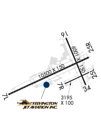
Runway Identification: 07L/25R
Length: 10500 ft
Width: 150 ft
Surface: CONCRETE ASPHALT-GOOD CONDITION
Edge lights: High Intensity

Treatment: GROOVED
Weight: PCN 66 /R/B/W/T

 Runway: 07L   Runway: 25R
Mag heading: 70°Mag heading: 250°
Rwy Slope: .04% UpRwy Slope: -.04% Down
Approach: LOC/GSApproach: ILS/DME
Pattern: Left TrafficPattern: Right Traffic
Markings: PRECISION INSTRUMENTMarkings: PRECISION INSTRUMENT
Marking Condition: GOODMarking Condition: GOOD
Arresting Dev: Arresting Dev:
Lat & Long: N2910.4  W08104.7Lat. & Long.: N2911.1  W08102.9
Elev: 28.3 ft. MSLElev: 32.7 ft. MSL
TCH: TCH: 72 ft. AGL
Visual Glide Path: Visual Glide Path: 3.00 degrees
Displaced Threshold: 690 feetDisplaced Threshold: No
Touchdown Zone: YESTouchdown Zone: YES
Touchdown Elev.: 30.0 feetTouchdown Elev.: 34.2 feet
Visual Glide Slope: Visual Glide Slope: 4-Light PAPI on LEFT side of Runway; PAPI UNUSBL BYD 5 DEG LEFT & RIGHT OF CNTRLN.
RVR Equipment: TOUCHDOWNRVR Equipment: ROLLOUT
RVV Equipment: NORVV Equipment: NO
Approach Lights: MALSR - 1,400 foot medium intensity approach lighting system with runway alignment indicator lightsApproach Lights: MALSR - 1,400 foot medium intensity approach lighting system with runway alignment indicator lights
REIL: NOREIL: NO
Centerline Lights: YESCenterline Lights: YES
Touchdown lights: YESTouchdown lights: NO
Runway Category: Precision Instrument RunwayRunway Category: Precision Instrument Runway
Declared Distances: TORA:10500' TODA:10500' ASDA:10500' LDA:9810'Declared Distances: TORA:10500' TODA:10500' ASDA:10293' LDA:10293'
Obstructions: ROADObstructions: TREES
Marked: NOT Marked/LightedMarked: NOT Marked/Lighted
Clearance slope: 39:1; RWY 07L APCH SLP 50:1 TO DSPLCD THR.Clearance slope: 50:1
Obstruction height: 15 feet AGLObstruction height: 43 feet AGL
Dist. from runway: 790 feetDist. from runway: 2370 feet
Centerline offset: 500 left of centerlineCenterline offset: 230 feet left of centerline
Comments: Comments:
Runway Identification: 07R/25L
Length: 3195 ft
Width: 100 ft
Surface: ASPHALT-POOR CONDITION
Edge lights: Medium Intensity

Treatment: NONE
Weight: PCN 7 /F/B/Y/T

 Runway: 07R   Runway: 25L
Mag heading: 70°Mag heading: 250°
Rwy Slope: .12% UpRwy Slope: -.12% Down
Approach: Approach:
Pattern: Right TrafficPattern: Left Traffic
Markings: NONPRECISION INSTRUMENTMarkings: NONPRECISION INSTRUMENT
Marking Condition: GOODMarking Condition: GOOD
Arresting Dev: Arresting Dev:
Lat & Long: N2910.6  W08103.4Lat. & Long.: N2910.8  W08102.9
Elev: 28.5 ft. MSLElev: 32.3 ft. MSL
TCH: 48 ft. AGLTCH: 44 ft. AGL
Visual Glide Path: 3.00 degreesVisual Glide Path: 3.00 degrees
Displaced Threshold: NoDisplaced Threshold: No
Touchdown Zone: YESTouchdown Zone: YES
Touchdown Elev.: 32.6 feetTouchdown Elev.: 32.6 feet
Visual Glide Slope: 2-Light PAPI on LEFT side of RunwayVisual Glide Slope: 2-Light PAPI on LEFT side of Runway
RVR Equipment: RVR Equipment:
RVV Equipment: NORVV Equipment: NO
Approach Lights: Approach Lights:
REIL: YESREIL: YES
Centerline Lights: NOCenterline Lights: NO
Touchdown lights: NOTouchdown lights: NO
Runway Category: Runway with a Non-precision ApproachRunway Category: Runway with a Non-precision Approach
Declared Distances: TORA:3195' TODA:3195' ASDA:3195' LDA:3195'Declared Distances: TORA:3195' TODA:3195' ASDA:3195' LDA:3195'
Obstructions: TREESObstructions: TREES
Marked: NOT Marked/LightedMarked: NOT Marked/Lighted
Clearance slope: 25:1Clearance slope: 30:1
Obstruction height: 55 feet AGLObstruction height: 42 feet AGL
Dist. from runway: 1580 feetDist. from runway: 1485 feet
Centerline offset: 185 left of centerlineCenterline offset: 105 feet left of centerline
Comments: Comments:
Runway Identification: 16/34
Length: 6001 ft
Width: 150 ft
Surface: ASPHALT-FAIR CONDITION
Edge lights: Medium Intensity

Treatment: GROOVED
Weight: PCN 58 /F/B/W/T

 Runway: 16   Runway: 34
Mag heading: 162°Mag heading: 342°
Rwy Slope: .03% UpRwy Slope: -.03% Down
Approach: Approach:
Pattern: Left TrafficPattern: Left Traffic
Markings: NONPRECISION INSTRUMENTMarkings: NONPRECISION INSTRUMENT
Marking Condition: GOODMarking Condition: GOOD
Arresting Dev: Arresting Dev:
Lat & Long: N2911.5  W08103.4Lat. & Long.: N2910.5  W08102.9
Elev: 30.8 ft. MSLElev: 32.5 ft. MSL
TCH: 50 ft. AGLTCH: 50 ft. AGL
Visual Glide Path: 3.00 degreesVisual Glide Path: 3.00 degrees
Displaced Threshold: NoDisplaced Threshold: No
Touchdown Zone: YESTouchdown Zone: YES
Touchdown Elev.: 33.7 feetTouchdown Elev.: 34.0 feet
Visual Glide Slope: 4-Light PAPI on LEFT side of RunwayVisual Glide Slope: 4-Light PAPI on LEFT side of Runway
RVR Equipment: RVR Equipment:
RVV Equipment: NORVV Equipment: NO
Approach Lights: Approach Lights:
REIL: YESREIL: YES
Centerline Lights: NOCenterline Lights: NO
Touchdown lights: NOTouchdown lights: NO
Runway Category: Runway with a Non-precision Approach having visibility minimums greater than 3/4 mileRunway Category: Runway with a Non-precision Approach having visibility minimums greater than 3/4 mile
Declared Distances: TORA:6001' TODA:6001' ASDA:5969' LDA:5969'Declared Distances: TORA:6001' TODA:6001' ASDA:6001' LDA:6001'
Obstructions: TREESObstructions: TREES
Marked: NOT Marked/LightedMarked: NOT Marked/Lighted
Clearance slope: 34:1Clearance slope: 20:1
Obstruction height: 42 feet AGLObstruction height: 46 feet AGL
Dist. from runway: 1630 feetDist. from runway: 1130 feet
Centerline offset: 275 left of centerlineCenterline offset: 400 feet left of centerline
Comments: Comments:
C:98/P: