
| ||||||||||||||||||||||||||||||||
| ||||||||||||||||||||||||||||||||
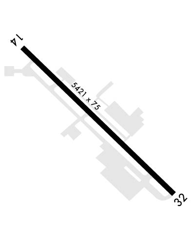
| Rwy | Rwy | |||||||
| 5421x75 | 4930' | 5421x75 | 4529' | 108.90 - 322° | ||||
| Runway ID | Single Wheel | Double Wheel | Double Tandem Wheel | Dual Double Wheel |
| 14/32 | N/A | N/A | N/A | N/A |
| H1 | N/A | N/A | N/A | N/A |
| These numbers are Advisory and are not limits. The Airport Manager should have more accurate Weight Limits | ||||
 Airport Diagram might not be current. | |
| Facility Name: | DAVISON AAF |
| City Name: | FORT BELVOIR |
| County: | FAIRFAX |
| State abbrev: | VA |
| State Name: | VIRGINIA |
| Ownership: | ARMY OWNED |
| Use: | PRIVATE |
| Owner's Name: | DAVISON ARMY AIRFIELD |
| Address: | US ARMY ATCA-ASO, 6970 BRITTON DR |
| FT BELVIOR, VA 22060 | |
| Owner's Phone: | |
| Manager's Name: | |
| Address: | |
| Phone: | 703-664-1201 |
| FAA Region: | EASTERN |
| FAA Field Office: | DCA |
| Date | Sunrise | Sunset |
|---|---|---|
| 04/23/24 Tuesday | 6:20 | 19:54 |
| 04/24/24 Wednesday | 6:19 | 19:55 |
| 04/25/24 Thursday | 6:18 | 19:56 |
| 04/26/24 Friday | 6:17 | 19:57 |
| 04/27/24 Saturday | 6:15 | 19:58 |
| 04/28/24 Sunday | 6:14 | 19:59 |
| 04/29/24 Monday | 6:13 | 20:00 |
| 04/30/24 Tuesday | 6:12 | 20:01 |
| 05/01/24 Wednesday | 6:10 | 20:02 |
| 05/02/24 Thursday | 6:09 | 20:03 |
| 05/03/24 Friday | 6:08 | 20:04 |
| 05/04/24 Saturday | 6:07 | 20:05 |
| 05/05/24 Sunday | 6:06 | 20:05 |
| 05/06/24 Monday | 6:05 | 20:06 |
| Airport Attendance Schedule | CONTINUOUS |
| Airport Status | OPERATIONAL (This Status can change at any time - please check NOTAMS) |
| Airport Lighting Schedule | AVBL 0230-1100Z++ MON-FRI AND 24 HRS ON WKNDS AND HOLS. WHEN TWR CLSD HIRL RWY 14-32 SET TO PCL. TO ACTVT & INCR INTS MALSF RWY 32; PAPI RWY 14 & 32 - CTAF. |
| Airport Storage Available | NONE |
| Extra Services Available | NONE |
| Wind Indicator | NONE |
| Control Tower | YES |
| CTAF Frequency | 124.275 |
| Unicom Frequency | |
| Rotating Beacon Color | SWG |
| Segmented Circle | NO |
| Landing Fee |
| Airport Inspected | No Inspection Data Available performed by the OWNER |
| Inspection Date | Unknown |
| Type of Fuel Available | None |
| Airframe Repair Service | None |
| Power Plant Repair Service | None |
| Latitude | N3842.9 |
| Longitude | W07710.9 (ESTIMATED) |
| Arpt Elevation | 73ft (SURVEYED) |
| Magnetic Variation | 09W |
| 3 miles NW | of FORT BELVOIR |
| Traffic Pattern Altitude | 1100 |
| Sectional Chart | WASHINGTON |
| Operations (Reported) | Yearly | Avg. Daily |
|---|---|---|
| General Aviation Transient | 0 | 0 |
| General Aviation Local | 0 | 0 |
| Air Taxi | 0 | 0 |
| Commerical | 0 | 0 |
| Commuter | 0 | 0 |
| Military | 0 | 0 |
| Aircraft based on Field | |
|---|---|
| General Aviation Singles | 0 |
| General Aviation Multi | 0 |
| Jet Aircraft | 0 |
| General Aviation Helicopters | 0 |
| Military Aircraft | 0 |
| Gliders | 0 |
| Ultralights | 0 |
| FSS on field | NO |
| FSS tie-in | LEESBURG |
| FSS Phone | 1-800-WX-BRIEF |
| Who issues Notams | DCA |
| Notam D service at airport | YES |
| ARTCC Name | WASHINGTON |
| Airport Certification | |
| Aircraft Rescue & Firefighting Index | None |
| Airport of Entry | No |
| Custom Landing Rights | No |
| Joint Civil/Military | No |
| Military Landing rights | No |
| FUEL: FUEL - J8. AVBL 1200-0300Z++ MON-FRI; 1330-2130Z++ SAT-SUN. |
| MISC-AERODROME BEACON LOCATED 4600 FT E-NE OF AFLD ON TOP OF DLA BLDG. |
| RSTD: RWY 14 PAPI ARE NON-STANDARD. VFR USE ONLY. |
| FOR CD WHEN ATCT IS CLSD CTC POTOMAC APCH AT 866-599-3874. |
| RSTD: TWY G, H, AND J CLSD FOR NIGHT AND IFR OPS DUE TO BEING UNLIT. |
| RSTD: HELIPAD 14/32 IS 50 FT BY 50 FT WIDE. LMTD TO H-60 AND SMALLER ACFT OPS. |
| HAZARDS: RWY 14 INBRD (INGROUND) THR LGTS ARE REMOVED. |
| RSTD: HELIPAD 14/32 CLSD FOR NIGHT AND IFR OPS DUE TO BEING UNLIT. |
| OIL: 0-123-128-148-156. |
| OFFL BUS ONLY. PPR 24 HR NOTICE FOR ALL NON DAA BASED ACFT, CTC BASE OPS 1200-2100Z++ WKD, C571-515-4226/4228/4424. |
| RSTD: 24 HR PPR NVESD RAMP, DSN 656-7675/7676, C703-806-7675/7676. |
| CAUTON: EXP SHEAR/CROSSWIND SHIFT TDZ RWY 32 DUR SW-NW WIND. BIRD AND DEER HAZ. |
| TFC PAT: F/W R/W SW 1500 FT, R/W/NE 1100 FT. |
| NS ABTMT: TWR WILL ADVS OF RSTD TO ENG RUN-UP, TKOF AND LDG BTN 0300-1300Z++ MON-SAT;2200-1700Z++ SUN AND HOL. |
| MISC: WITH CTL TWR/OPR APV, DEP ACFT MAY USE RWY APCH END OVRN FOR TKOF ROLL. WX FCST 1100-0230Z++ MON-FRI, EXC HOL, OT REMOTE BRIEFING SVC AVBL 15TH OWS, SCOTT AFB DSN 576-9755, C618-256-9755, FAX EXTN 4855 0R HTTP://OWS.SCOTT.AF.MIL. SEE VFR-S FOR PENTAGON HELIPORT. |
| ARNG: OPR 24/7. 24 HR PPR FOR TRAN ACFT, DSN 656-7092/7690, C703-806-7092/7690 FAX 7298. |
Airport Communications & Frequencies:
| |||||||||||||||||||||||||||||||||||||||||
| Runway: 14 | Runway: 32 | ||
| Mag heading: | 142° | Mag heading: | 322° |
| Rwy Slope: | .45% Up | Rwy Slope: | -.45% Down |
| Approach: | Approach: | ILS/DME | |
| Pattern: | Left Traffic | Pattern: | Left Traffic |
| Markings: | PRECISION INSTRUMENT | Markings: | PRECISION INSTRUMENT |
| Marking Condition: | GOOD | Marking Condition: | GOOD |
| Arresting Dev: | Arresting Dev: | ||
| Lat & Long: | N3843.2 W07711.3 | Lat. & Long.: | N3842.6 W07710.4 |
| Elev: | 48.8 ft. MSL | Elev: | 73.4 ft. MSL |
| TCH: | 68 ft. AGL | TCH: | 35 ft. AGL |
| Visual Glide Path: | 3.00 degrees | Visual Glide Path: | 3.00 degrees |
| Displaced Threshold: | 491 feet | Displaced Threshold: | 892 feet |
| Touchdown Zone: | YES | Touchdown Zone: | YES |
| Touchdown Elev.: | 59.9 feet | Touchdown Elev.: | 68.1 feet |
| Visual Glide Slope: | 4-Light PAPI on LEFT side of Runway | Visual Glide Slope: | 4-Light PAPI on RIGHT side of Runway |
| RVR Equipment: | ROLLOUT | RVR Equipment: | TOUCHDOWN |
| RVV Equipment: | NO | RVV Equipment: | NO |
| Approach Lights: | NATO STD APPROACH LGTS (BP). | Approach Lights: | MALSF - 1,400 foot medium intensity approach lighting system with sequenced flashers |
| REIL: | NO | REIL: | NO |
| Centerline Lights: | NO | Centerline Lights: | NO |
| Touchdown lights: | NO | Touchdown lights: | NO |
| Runway Category: | Runway Category: | ||
| Declared Distances: | Declared Distances: |
