Approach Charts
| FltPlan does not have IFR approach charts available for KD83. |
Current Weather/Notams (Metars, TAFs, Notams, NWS Forecast, PIREPS, and nearby weather)
Customs Information Send updates to Support@FltPlan.com
Customs Not Available
Database effective 05/16/2024
Airport Diagram might not be current.
|
| Facility Name: | BOONVILLE |
| City Name: | BOONVILLE |
| County: | MENDOCINO |
| State abbrev: | CA |
| State Name: | CALIFORNIA |
| | |
| Ownership: | PUBLICLY OWNED |
| Use: | OPEN TO THE PUBLIC |
| Owner's Name: | ANDERSON VALLEY COMM.SVC DST. |
| Address: | P.O. BOX 398 |
| | BOONVILLE, CA 95415 |
| Owner's Phone: | 707-895-2075 |
| | |
| Manager's Name: | KIRK WILDER |
| Address: | 13461 AIRPORT ROAD |
| | BOONVILLE, CA 95415 |
| Phone: | 707-234-9593 |
| | |
| FAA Region: | WESTERN-PACIFIC |
| FAA Field Office: | SFO |
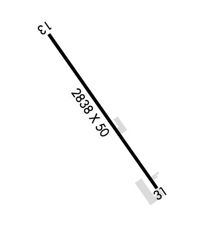
Runway Identifications
Runway Identification: 13/31Length: 2838 ft
Width: 50 ft
Surface: ASPHALT-GOOD CONDITION
Edge lights: Treatment: NONE
| | Runway: 13 | | Runway: 31 |
| Mag heading: | N/A | Mag heading: | N/A |
| Rwy Slope: | .87% Up | Rwy Slope: | -.87% Down |
| Approach: | | Approach: | |
| Pattern: | Left Traffic | Pattern: | Right Traffic |
| Markings: | BASIC | Markings: | BASIC |
| Marking Condition: | GOOD | Marking Condition: | GOOD |
| Arresting Dev: | | Arresting Dev: | |
| Lat & Long: | N3901.0 W12323.1 | Lat. & Long.: | N3900.7 W12322.7 |
| Elev: | 353.9 ft. MSL | Elev: | 378.5 ft. MSL |
| TCH: | | TCH: | |
| Visual Glide Path: | | Visual Glide Path: | |
| Displaced Threshold: | 253 feet | Displaced Threshold: | 95 feet |
| Touchdown Zone: | NO | Touchdown Zone: | NO |
| Touchdown Elev.: | | Touchdown Elev.: | |
| Visual Glide Slope: | | Visual Glide Slope: | |
| RVR Equipment: | | RVR Equipment: | |
| RVV Equipment: | NO | RVV Equipment: | NO |
| Approach Lights: | | Approach Lights: | |
| REIL: | NO | REIL: | NO |
| Centerline Lights: | NO | Centerline Lights: | NO |
| Touchdown lights: | NO | Touchdown lights: | NO |
| Runway Category: | Runway with a Visual Approach | Runway Category: | Runway with a Visual Approach |
| Declared Distances: | | Declared Distances: | |
| Obstructions: | TREES | Obstructions: | HILL |
| Marked: | NOT Marked/Lighted | Marked: | NOT Marked/Lighted |
| Clearance slope: | 5:1; APCH RATIO 24:1 TO DSPLCD THLD; APCH RATIO TO DSPLD THLD OVER 92 FT TREES AT 1200 FT, 175 FT R FM EOR 18:1. | Clearance slope: | 20:1; APCH RATIO 22:1 TO DSPLCD THR; APCH RATIO TO DSPLCD THR OVER +15 FT ROAD 375 FT FM DSPLCD THR 125 FT LEFT 20:1. |
| Obstruction height: | 35 feet AGL | Obstruction height: | 185 feet AGL |
| Dist. from runway: | 400 feet | Dist. from runway: | 3900 feet |
| Centerline offset: | 20 left of centerline | Centerline offset: | 500 feet left of centerline |
| Comments: | 5' FENCE 250' FROM END OF RWY. | Comments: | PUBLIC ROAD 235' FM RWY END. |

