Current Weather/Notams (Metars, TAFs, Notams, NWS Forecast, PIREPS, and nearby weather)
Customs Information Send updates to Support@FltPlan.com
Customs Not Available
Database effective 05/16/2024
Airport Diagram might not be current.
|
| Facility Name: | CY NUNNALLY MEML |
| City Name: | MONROE |
| County: | WALTON |
| State abbrev: | GA |
| State Name: | GEORGIA |
| | |
| Ownership: | PUBLICLY OWNED |
| Use: | OPEN TO THE PUBLIC |
| Owner's Name: | CITY OF MONROE |
| Address: | CITY HALL, PO BOX 1249 |
| | MONROE, GA 30655 |
| Owner's Phone: | 770-267-7536 |
| | |
| Manager's Name: | CHRIS BAILEY |
| Address: | 215 NORTH BROAD STREET |
| | MONROE, GA 30655 |
| Phone: | 770-267-7536 |
| | |
| FAA Region: | SOUTHERN |
| FAA Field Office: | ATL |
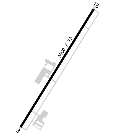
Runway Identifications
Runway Identification: 03/21Length: 5000 ft
Width: 75 ft
Surface: ASPHALT
Edge lights: Medium IntensityTreatment: NONE
| | Runway: 03 | | Runway: 21 |
| Mag heading: | 35° | Mag heading: | 215° |
| Rwy Slope: | -1.02% Down | Rwy Slope: | 1.02% Up |
| Approach: | | Approach: | |
| Pattern: | Left Traffic | Pattern: | Left Traffic |
| Markings: | NONPRECISION INSTRUMENT | Markings: | NONPRECISION INSTRUMENT |
| Marking Condition: | GOOD | Marking Condition: | GOOD |
| Arresting Dev: | | Arresting Dev: | |
| Lat & Long: | N3346.6 W08341.8 | Lat. & Long.: | N3347.3 W08341.3 |
| Elev: | 875.2 ft. MSL | Elev: | 824.1 ft. MSL |
| TCH: | 51 ft. AGL | TCH: | 43 ft. AGL |
| Visual Glide Path: | 4.00 degrees | Visual Glide Path: | 3.50 degrees |
| Displaced Threshold: | No | Displaced Threshold: | No |
| Touchdown Zone: | YES | Touchdown Zone: | YES |
| Touchdown Elev.: | 875.2 feet | Touchdown Elev.: | 844.4 feet |
| Visual Glide Slope: | 2-Light PAPI on LEFT side of Runway | Visual Glide Slope: | 2-Light PAPI on LEFT side of Runway |
| RVR Equipment: | | RVR Equipment: | |
| RVV Equipment: | NO | RVV Equipment: | NO |
| Approach Lights: | | Approach Lights: | |
| REIL: | NO | REIL: | NO |
| Centerline Lights: | NO | Centerline Lights: | NO |
| Touchdown lights: | NO | Touchdown lights: | NO |
| Runway Category: | Runway with a Non-precision Approach having visibility minimums greater than 3/4 mile | Runway Category: | Runway with a Visual Approach |
| Declared Distances: | | Declared Distances: | |
| Obstructions: | TREES | Obstructions: | TREES |
| Marked: | NOT Marked/Lighted | Marked: | NOT Marked/Lighted |
| Clearance slope: | 7:1 | Clearance slope: | 2:1 |
| Obstruction height: | 86 feet AGL | Obstruction height: | 21 feet AGL |
| Dist. from runway: | 874 feet | Dist. from runway: | 243 feet |
| Centerline offset: | 326 right of centerline | Centerline offset: | 253 feet left of centerline |
| Comments: | 1'-4' FT BERM, 1'-200' FROM THRESHOLD, 240' RIGHT OF CENTERLINE | Comments: | |

