Click here for more info on on SMS!

KD31

LEEDS MUNI
LEEDS
ND
Time Zone: Central
Lat: N 4817.1
Long: W 09924.1
Elev: 1508
Var: -09
Longest Runway: 3000
CTAF: 122.8

FBO & Flight Services info for KD31

FBOs: Update your Fuel Prices

AIRPORT MANAGERPh: 701-466-2253
-
Freq: 122.8
Service
Jet
100LL
SAF
MoGas
Fuel Avail: NO FUEL AVAILABLE
Full        Last Update: 04/25/2024 05:27:32

Self        
If you are an FBO, call 1-203-262-1700 to update your info or email: FltPlan.Advertising@garmin.com
Advertise your FBO on FltPlan.com

Runway & Approach Info for KD31
Rwy
Length
Land Dist**
Approach*
  Rwy
Length
Land Dist**
Approach*
09
3000x50  3000'          
 
  
27
  3000x50  3000'          
 
 * only ILS, LOC, LDA, and SDF approaches to a specific runway are shown
** For any Declared Landing Distance Available, please see A/FD or Approach plates
Runway Weight Capability (lbs.) Help
Runway IDSingle WheelDouble WheelDouble Tandem WheelDual Double Wheel
09/277,000N/AN/AN/A
These numbers are Advisory and are not limits.   The Airport Manager should have more accurate Weight Limits
Approach Charts
FltPlan does not have IFR approach charts available for KD31.
Current Weather/Notams
Customs Information Send updates to Support@FltPlan.com
Customs Not Available
Database effective 05/16/2024
Airport Diagram of KD31
Airport Diagram might not be current.

Facility Name: LEEDS MUNI
City Name: LEEDS
County: BENSON
State abbrev: ND
State Name: NORTH DAKOTA
   
Ownership: PUBLICLY OWNED
Use: OPEN TO THE PUBLIC
Owner's Name: LEEDS MUNICIPAL AIRPORT AUTHORITY; ERIKA KENNER, CHRMN OF ARPT AUTH
Address: 440 6TH AVE SE
 LEEDS, ND 58346
Owner's Phone: (406) 581-1188
  
Manager's Name: ERIKA KENNER
Address: 440 6TH AVE SE
 LEEDS, ND 58346
Phone: 406-581-1188
   
FAA Region: GREAT LAKES
FAA Field Office: DMA


Sunrise / Sunset times for LEEDS MUNI

DateSunriseSunset
04/24/24 Wednesday6:2920:43
04/25/24 Thursday6:2820:44
04/26/24 Friday6:2620:46
04/27/24 Saturday6:2420:47
04/28/24 Sunday6:2220:48
04/29/24 Monday6:2120:50
04/30/24 Tuesday6:1920:51
05/01/24 Wednesday6:1720:53
05/02/24 Thursday6:1620:54
05/03/24 Friday6:1420:56
05/04/24 Saturday6:1220:57
05/05/24 Sunday6:1120:58
05/06/24 Monday6:0921:00
05/07/24 Tuesday6:0821:01

Airport Facilities

Airport Attendance ScheduleUNATTENDED
Airport Status OPERATIONAL (This Status can change at any time - please check NOTAMS)
Airport Lighting Schedule
Airport Storage AvailableNONE
Extra Services AvailableCrop Dusting
Wind IndicatorYES - (unlit)
Control TowerNO
CTAF Frequency122.800
Unicom Frequency122.800
Rotating Beacon Color
Segmented CircleYES
Landing Fee

Airport Inspection Data

Airport InspectedSTATE - performed by STATE AERONAUTICAL PERSONNEL
Inspection Date05/19/2020

Airport Services

Type of Fuel AvailableNone
Airframe Repair ServiceNONE
Power Plant Repair ServiceNONE

Geographic Data

LatitudeN4817.1
LongitudeW09924.1 (ESTIMATED)
Arpt Elevation1508ft (SURVEYED)
Magnetic Variation09E
2 miles Eof LEEDS
Traffic Pattern Altitude
Sectional ChartTWIN CITIES

Aircraft Data

Operations (Reported)YearlyAvg. Daily
General Aviation Transient 12003
General Aviation Local 14004
Air Taxi 100
Commerical 00
Commuter 00
Military 100
Aircraft based on Field
General Aviation Singles 2
General Aviation Multi 0
Jet Aircraft 0
General Aviation Helicopters 0
Military Aircraft 0
Gliders 0
Ultralights 0

FAA Services

FSS on field NO
FSS tie-in GRAND FORKS
FSS Phone 1-800-WX-BRIEF
Who issues Notams GFK
Notam D service at airport YES
ARTCC Name MINNEAPOLIS

Federal Status

Airport Certification
Aircraft Rescue & Firefighting IndexNone
Airport of EntryNo
Custom Landing RightsNo
Joint Civil/MilitaryNo
Military Landing rightsNo

Remarks

CFM WINTER CONDS & SNOW REMOVAL AFTER MAJOR STORMS CALL MGR GARY LARSON (701) 740-7309.
MIGRATORY WATERFOWL ON AND INVOF ARPT APR-MAY AND SEP-NOV.
RY 27 SAFETY AREA 200 FT OUT IS ROUGH WITH CLUMPY GRASS.
FOR CD CTC MINNEAPOLIS ARTCC AT 651-463-5588.
RWY 09/2 7 HAS 600 FT LGTD TURF STWY W END.
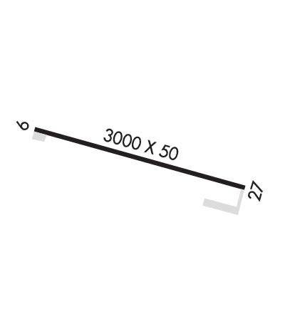
Runway Identifications
Runway Identification: 09/27
Length: 3000 ft
Width: 50 ft
Surface: ASPHALT-FAIR CONDITION
Edge lights:

Treatment: NONE

 Runway: 09   Runway: 27
Mag heading: N/AMag heading: N/A
Rwy Slope: .00%Rwy Slope: .00%
Approach: Approach:
Pattern: Left TrafficPattern: Left Traffic
Markings: BASICMarkings: BASIC
Marking Condition: FAIRMarking Condition: FAIR
Arresting Dev: Arresting Dev:
Lat & Long: N4817.1  W09924.5Lat. & Long.: N4817.1  W09923.8
Elev: 1500.0 ft. MSLElev: 1500.0 ft. MSL
TCH: TCH:
Visual Glide Path: Visual Glide Path:
Displaced Threshold: NoDisplaced Threshold: No
Touchdown Zone: NOTouchdown Zone: NO
Touchdown Elev.: Touchdown Elev.:
Visual Glide Slope: Visual Glide Slope:
RVR Equipment: RVR Equipment:
RVV Equipment: NORVV Equipment: NO
Approach Lights: Approach Lights:
REIL: NOREIL: NO
Centerline Lights: NOCenterline Lights: NO
Touchdown lights: NOTouchdown lights: NO
Runway Category: Runway with a Visual ApproachRunway Category: Runway with a Visual Approach
Declared Distances: Declared Distances:
Obstructions: Obstructions: ROAD
Marked: Marked: NOT Marked/Lighted
Clearance slope: 20:1Clearance slope: 9:1
Obstruction height: Obstruction height: 13 feet AGL
Dist. from runway: Dist. from runway: 320 feet
Centerline offset: Centerline offset: 150B
Comments: Comments:
C:/P: