Current Weather/Notams (Metars, TAFs, Notams, NWS Forecast, PIREPS, and nearby weather)
Customs Information Send updates to Support@FltPlan.com
Customs Not Available
Database effective 04/18/2024
Airport Diagram might not be current.
|
| Facility Name: | DIMMIT COUNTY |
| City Name: | CARRIZO SPRINGS |
| County: | DIMMIT |
| State abbrev: | TX |
| State Name: | TEXAS |
| | |
| Ownership: | PUBLICLY OWNED |
| Use: | OPEN TO THE PUBLIC |
| Owner's Name: | DIMMIT COUNTY |
| Address: | DIMMIT CO COURTHOUSE |
| | CARRIZO SPRINGS, TX 78834 |
| Owner's Phone: | 830-876-2323 |
| | |
| Manager's Name: | ERNEST MARTINEZ, JR |
| Address: | PO BOX 432 |
| | CARRIZO SPRINGS, TX 78834 |
| Phone: | 830-876-2967; CELL PHONE. |
| | |
| FAA Region: | SOUTHWEST |
| FAA Field Office: | TEX |
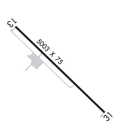
Runway Identifications
Runway Identification: 13/31Length: 5003 ft
Width: 75 ft
Surface: ASPHALT
Edge lights: Medium IntensityTreatment: NONE
| | Runway: 13 | | Runway: 31 |
| Mag heading: | 127° | Mag heading: | 307° |
| Rwy Slope: | -.31% Down | Rwy Slope: | .31% Up |
| Approach: | | Approach: | |
| Pattern: | Left Traffic | Pattern: | Left Traffic |
| Markings: | NONPRECISION INSTRUMENT | Markings: | NONPRECISION INSTRUMENT |
| Marking Condition: | GOOD | Marking Condition: | GOOD |
| Arresting Dev: | | Arresting Dev: | |
| Lat & Long: | N2831.6 W09949.8 | Lat. & Long.: | N2831.0 W09949.1 |
| Elev: | 598.1 ft. MSL | Elev: | 582.7 ft. MSL |
| TCH: | 40 ft. AGL | TCH: | 40 ft. AGL |
| Visual Glide Path: | 3.00 degrees | Visual Glide Path: | 3.00 degrees |
| Displaced Threshold: | No | Displaced Threshold: | No |
| Touchdown Zone: | YES | Touchdown Zone: | YES |
| Touchdown Elev.: | 598.1 feet | Touchdown Elev.: | 589.2 feet |
| Visual Glide Slope: | 4-Light PAPI on LEFT side of Runway | Visual Glide Slope: | 4-Light PAPI on LEFT side of Runway |
| RVR Equipment: | | RVR Equipment: | |
| RVV Equipment: | NO | RVV Equipment: | NO |
| Approach Lights: | | Approach Lights: | |
| REIL: | NO | REIL: | NO |
| Centerline Lights: | NO | Centerline Lights: | NO |
| Touchdown lights: | NO | Touchdown lights: | NO |
| Runway Category: | Runway with a Non-precision Approach having visibility minimums greater than 3/4 mile | Runway Category: | Runway with a Non-precision Approach having visibility minimums greater than 3/4 mile |
| Declared Distances: | | Declared Distances: | |
| Obstructions: | TREES | Obstructions: | POLE |
| Marked: | NOT Marked/Lighted | Marked: | NOT Marked/Lighted |
| Clearance slope: | 33:1 | Clearance slope: | 38:1 |
| Obstruction height: | 10 feet AGL | Obstruction height: | 35 feet AGL |
| Dist. from runway: | 533 feet | Dist. from runway: | 1550 feet |
| Centerline offset: | 250 left of centerline | Centerline offset: | 100 feet right of centerline |
| Comments: | | Comments: | |

