Click here for more info on on SMS!

KCZL

TOM B. DAVID FLD
CALHOUN
GA
Time Zone: Eastern
Lat: N 3427.3
Long: W 08456.3
Elev: 656
Var: +05
Longest Runway: 6034
AWOS: 119.97
CTAF: 122.8

FBO & Flight Services info for KCZL

FBOs: Update your Fuel Prices

TOM B DAVID FIELDPh: 706-602-8000 Fax: 706-602-8001 Freq: 122.8
Service
Jet
100LL
SAF
MoGas
Fuel Avail: Prist Premixed. VOLUME DISCOUNTS AVAILABLE OVER 100 GAL
Full5.09      Caution: Fuel prices have not been updated in 42 days.
Last Update: 03/07/2024 14:10

Self  5.19    
 Address: 1957 US HWY 41 S,   CALHOUN, GA 30701
AWOSPh: 706-602-5906
-
Freq: 119.97  
If you are an FBO, call 1-203-262-1700 to update your info or email: FltPlan.Advertising@garmin.com
Advertise your FBO on FltPlan.com

Runway & Approach Info for KCZL
Rwy
Length
Land Dist**
Approach*
  Rwy
Length
Land Dist**
Approach*
17
6034x100  6034'          
 
  
35
  6034x100  5648'          
LOCALIZER
 110.70 - 353°  
 * only ILS, LOC, LDA, and SDF approaches to a specific runway are shown
** For any Declared Landing Distance Available, please see A/FD or Approach plates
Runway Weight Capability (lbs.) Help
Runway IDSingle WheelDouble WheelDouble Tandem WheelDual Double Wheel
17/3515,000100,000100,000N/A
These numbers are Advisory and are not limits.   The Airport Manager should have more accurate Weight Limits
Approach Charts
Approaches    
Current Weather/Notams
Customs Information Send updates to Support@FltPlan.com
Customs Not Available
Database effective 04/18/2024
Airport Diagram of KCZL
Airport Diagram might not be current.

Facility Name: TOM B DAVID FLD
City Name: CALHOUN
County: GORDON
State abbrev: GA
State Name: GEORGIA
   
Ownership: PUBLICLY OWNED
Use: OPEN TO THE PUBLIC
Owner's Name: CALHOUN-GORDON CO ARPT AUTH
Address: 1957 HWY 41 S
 CALHOUN, GA 30701
Owner's Phone: 706-602-8000
  
Manager's Name: DWIGHT ALBRITTON
Address: 1957 HWY 41 S
 CALHOUN, GA 30701
Phone: 706-602-8000
   
FAA Region: SOUTHERN
FAA Field Office: ATL


Sunrise / Sunset times for TOM B DAVID FLD

DateSunriseSunset
04/17/24 Wednesday7:0520:14
04/18/24 Thursday7:0420:15
04/19/24 Friday7:0320:15
04/20/24 Saturday7:0120:16
04/21/24 Sunday7:0020:17
04/22/24 Monday6:5920:18
04/23/24 Tuesday6:5820:19
04/24/24 Wednesday6:5720:19
04/25/24 Thursday6:5620:20
04/26/24 Friday6:5420:21
04/27/24 Saturday6:5320:22
04/28/24 Sunday6:5220:23
04/29/24 Monday6:5120:23
04/30/24 Tuesday6:5020:24

Airport Facilities

Airport Attendance ScheduleNOV-MAR 7 Days A Week 0800-1800, APR-OCT 7 Days A Week 0800-2000
Airport Status OPERATIONAL (This Status can change at any time - please check NOTAMS)
Airport Lighting ScheduleACTVT PAPI RWY 17 & 35; MIRL RWY 17/35 - CTAF. MIRL RWY 17/35 PRESET ON MED INTST DUSK - 2200, TO INCR INTST & ACTVT AFT 2200 - CTAF.
Airport Storage AvailableTie Downs, Hanger
Extra Services AvailableAir Ambulance, Flight Instruction, Aircraft Rental, Annual Surveying
Wind IndicatorYES - (lighted)
Control TowerNO
CTAF Frequency122.800
Unicom Frequency122.800
Rotating Beacon ColorWG
Segmented CircleNO
Landing FeeNO

Airport Inspection Data

Airport InspectedSTATE - performed by STATE AERONAUTICAL PERSONNEL
Inspection Date04/12/2023

Airport Services

Type of Fuel AvailableGrade 100LL, JET A
Airframe Repair ServiceMAJOR
Power Plant Repair ServiceMAJOR

Geographic Data

LatitudeN3427.3
LongitudeW08456.3 (ESTIMATED)
Arpt Elevation655ft (SURVEYED)
Magnetic Variation05W
3 miles Sof CALHOUN
Traffic Pattern Altitude
Sectional ChartATLANTA

Aircraft Data

Operations (Reported)YearlyAvg. Daily
General Aviation Transient 800022
General Aviation Local 800022
Air Taxi 00
Commerical 00
Commuter 00
Military 00
Aircraft based on Field
General Aviation Singles 103
General Aviation Multi 7
Jet Aircraft 2
General Aviation Helicopters 12
Military Aircraft 0
Gliders 1
Ultralights 4

FAA Services

FSS on field NO
FSS tie-in MACON
FSS Phone 1-800-WX-BRIEF
Who issues Notams MCN
Notam D service at airport YES
ARTCC Name ATLANTA

Federal Status

Airport Certification
Aircraft Rescue & Firefighting IndexNone
Airport of EntryNo
Custom Landing RightsNo
Joint Civil/MilitaryNo
Military Landing rightsYES

Federal Agreements

NATIONAL PLAN OF INTEGRATED AIRPORT SYSTEMS (NPIAS)
GRANT AGREEMENTS UNDER FAAP/ADAP/AIP
ASSURANCES PURSUANT TO TITLE VI, CIVIL RIGHTS ACT OF 1964

Remarks

SELF-SVC FUEL AVBL WITH CREDIT CARD.
DEER & WILDLIFE ON OR INVOF ARPT.
FOR CD CTC ATLANTA ARTCC AT 770-210-7692.
Airport Communications & Frequencies:
CTAF Frequency:
122.800
Unicom Frequency:
122.800
Remarks
  • APCH/DEP SVC PRVDD BY ATLANTA ARTCC ON FREQS 124.5/270.325 (GADSDEN RCAG).
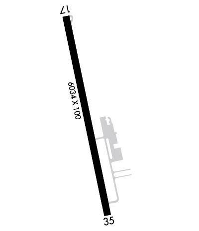
  • Runway Identifications
    Runway Identification: 17/35
    Length: 6034 ft
    Width: 100 ft
    Surface: ASPHALT-GOOD CONDITION
    Edge lights: Medium Intensity

    Treatment: NONE

     Runway: 17   Runway: 35
    Mag heading: 173°Mag heading: 353°
    Rwy Slope: .29% UpRwy Slope: -.29% Down
    Approach: Approach: LOCALIZER
    Pattern: Left TrafficPattern: Left Traffic
    Markings: NONPRECISION INSTRUMENTMarkings: NONPRECISION INSTRUMENT
    Marking Condition: GOODMarking Condition: GOOD
    Arresting Dev: Arresting Dev:
    Lat & Long: N3427.8  W08456.5Lat. & Long.: N3426.8  W08456.2
    Elev: 638.6 ft. MSLElev: 655.8 ft. MSL
    TCH: 44 ft. AGLTCH: 30 ft. AGL
    Visual Glide Path: 3.50 degreesVisual Glide Path: 3.00 degrees
    Displaced Threshold: NoDisplaced Threshold: 386 feet
    Touchdown Zone: YESTouchdown Zone: YES
    Touchdown Elev.: 638.6 feetTouchdown Elev.: 652.9 feet
    Visual Glide Slope: 4-Light PAPI on LEFT side of RunwayVisual Glide Slope: 4-Light PAPI on LEFT side of Runway
    RVR Equipment: RVR Equipment:
    RVV Equipment: NORVV Equipment: NO
    Approach Lights: Approach Lights:
    REIL: NOREIL: NO
    Centerline Lights: NOCenterline Lights: NO
    Touchdown lights: NOTouchdown lights: NO
    Runway Category: Runway with a Non-precision Approach having visibility minimums greater than 3/4 mileRunway Category: Runway with a Non-precision Approach having visibility minimums greater than 3/4 mile
    Declared Distances: TORA:6034' TODA:6034' ASDA:6034' LDA:6034'Declared Distances: TORA:6034' TODA:6034' ASDA:6034' LDA:5648'
    Obstructions: TREESObstructions: TREES
    Marked: NOT Marked/LightedMarked: NOT Marked/Lighted
    Clearance slope: 7:1Clearance slope: 16:1; APCH SLOPE 20:1 TO DSPLCD THLD, TREES 2172 FT OUT, 318 LEFT.
    Obstruction height: 21 feet AGLObstruction height: 97 feet AGL
    Dist. from runway: 347 feetDist. from runway: 1752 feet
    Centerline offset: 220 right of centerlineCenterline offset: 420 feet left of centerline
    Comments: Comments:
    C:6/P: