
| |||||||||||||||||||||||||||||||||||||||||||||||||||||||||||||||||||||
| |||||||||||||||||||||||||||||||||||||||||||||||||||||||||||||||||||||
| Rwy | Rwy | |||||||
| 5500x100 | 5500' | 5500x100 | 5500' | |||||
| Runway ID | Single Wheel | Double Wheel | Double Tandem Wheel | Dual Double Wheel |
| 04/22 | 30,000 | 60,000 | 120,000 | N/A |
| These numbers are Advisory and are not limits. The Airport Manager should have more accurate Weight Limits | ||||
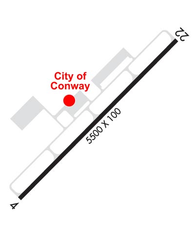 Airport Diagram might not be current. | |
| Facility Name: | CONWAY RGNL |
| City Name: | CONWAY |
| County: | FAULKNER |
| State abbrev: | AR |
| State Name: | ARKANSAS |
| Ownership: | PUBLICLY OWNED |
| Use: | OPEN TO THE PUBLIC |
| Owner's Name: | CITY OF CONWAY |
| Address: | 1111 MAIN STREET |
| CONWAY, AR 72032 | |
| Owner's Phone: | 501-450-6110 |
| Manager's Name: | JACOB BRILEY |
| Address: | 3250 SAND GAP ROAD |
| CONWAY, AR 72034 | |
| Phone: | 501-358-6200 |
| FAA Region: | SOUTHWEST |
| FAA Field Office: | AOK |
| Date | Sunrise | Sunset |
|---|---|---|
| 04/25/24 Thursday | 6:25 | 19:52 |
| 04/26/24 Friday | 6:24 | 19:52 |
| 04/27/24 Saturday | 6:23 | 19:53 |
| 04/28/24 Sunday | 6:22 | 19:54 |
| 04/29/24 Monday | 6:21 | 19:55 |
| 04/30/24 Tuesday | 6:20 | 19:56 |
| 05/01/24 Wednesday | 6:19 | 19:56 |
| 05/02/24 Thursday | 6:18 | 19:57 |
| 05/03/24 Friday | 6:16 | 19:58 |
| 05/04/24 Saturday | 6:16 | 19:59 |
| 05/05/24 Sunday | 6:15 | 20:00 |
| 05/06/24 Monday | 6:14 | 20:00 |
| 05/07/24 Tuesday | 6:13 | 20:01 |
| 05/08/24 Wednesday | 6:12 | 20:02 |
| Airport Attendance Schedule | 7 Days A Week 0800-1800; FOR SVC AFT HRS CALL 501-697-6476. |
| Airport Status | OPERATIONAL (This Status can change at any time - please check NOTAMS) |
| Airport Lighting Schedule | ACTVT REIL, PAPI AND MIRL RWYS 4 AND 22 - CTAF. |
| Airport Storage Available | Tie Downs, Hanger |
| Extra Services Available | Flight Instruction, Aircraft Rental |
| Wind Indicator | YES - (lighted) |
| Control Tower | NO |
| CTAF Frequency | 123.050 |
| Unicom Frequency | 123.050 |
| Rotating Beacon Color | WG |
| Segmented Circle | YES |
| Landing Fee | YES; FEE WAIVED IF FUEL IS PURCHASED. |
| Airport Inspected | No Inspection Data Available performed by STATE AERONAUTICAL PERSONNEL |
| Inspection Date | 04/21/2022 |
| Type of Fuel Available | Grade 100LL, JET A (freeze point -40C); -10FUEL AVBL 24 HRS SELF SVC WITH CREDIT CARD (100LL). |
| Airframe Repair Service | MAJOR |
| Power Plant Repair Service | MAJOR |
| Latitude | N3501.2 |
| Longitude | W09233.3 (ESTIMATED) |
| Arpt Elevation | 276ft (SURVEYED) |
| Magnetic Variation | 01E |
| 7 miles SW | of CONWAY |
| Traffic Pattern Altitude | |
| Sectional Chart | MEMPHIS |
| Operations (Reported) | Yearly | Avg. Daily |
|---|---|---|
| General Aviation Transient | 6000 | 16 |
| General Aviation Local | 8500 | 23 |
| Air Taxi | 100 | 0 |
| Commerical | 0 | 0 |
| Commuter | 0 | 0 |
| Military | 500 | 1 |
| Aircraft based on Field | |
|---|---|
| General Aviation Singles | 55 |
| General Aviation Multi | 9 |
| Jet Aircraft | 11 |
| General Aviation Helicopters | 0 |
| Military Aircraft | 0 |
| Gliders | 0 |
| Ultralights | 0 |
| FSS on field | NO |
| FSS tie-in | JONESBORO |
| FSS Phone | 1-800-WX-BRIEF |
| Who issues Notams | JBR |
| Notam D service at airport | No |
| ARTCC Name | MEMPHIS |
| Airport Certification | |
| Aircraft Rescue & Firefighting Index | None |
| Airport of Entry | No |
| Custom Landing Rights | No |
| Joint Civil/Military | No |
| Military Landing rights | No |
| NATIONAL PLAN OF INTEGRATED AIRPORT SYSTEMS (NPIAS) |
| GRANT AGREEMENTS UNDER FAAP/ADAP/AIP |
| FOR CD WHEN UNA VIA FREQ CTC LITTLE ROCK APCH 501-379-2908 OR LITTLE ROCK ATCT 501-379-2911 |
Airport Communications & Frequencies:
| ||||||||||||||||||||
| Runway: 04 | Runway: 22 | ||
| Mag heading: | N/A | Mag heading: | N/A |
| Rwy Slope: | .02% Up | Rwy Slope: | -.02% Down |
| Approach: | Approach: | ||
| Pattern: | Left Traffic | Pattern: | Left Traffic |
| Markings: | NONPRECISION INSTRUMENT | Markings: | NONPRECISION INSTRUMENT |
| Marking Condition: | GOOD | Marking Condition: | GOOD |
| Arresting Dev: | Arresting Dev: | ||
| Lat & Long: | N3500.9 W09233.7 | Lat. & Long.: | N3501.5 W09232.9 |
| Elev: | 274.8 ft. MSL | Elev: | 276.0 ft. MSL |
| TCH: | 40 ft. AGL | TCH: | 40 ft. AGL |
| Visual Glide Path: | 3.00 degrees | Visual Glide Path: | 3.00 degrees |
| Displaced Threshold: | No | Displaced Threshold: | No |
| Touchdown Zone: | YES | Touchdown Zone: | YES |
| Touchdown Elev.: | 275.5 feet | Touchdown Elev.: | 276.1 feet |
| Visual Glide Slope: | 2-Light PAPI on LEFT side of Runway | Visual Glide Slope: | 2-Light PAPI on LEFT side of Runway |
| RVR Equipment: | RVR Equipment: | ||
| RVV Equipment: | NO | RVV Equipment: | NO |
| Approach Lights: | Approach Lights: | ||
| REIL: | YES | REIL: | YES |
| Centerline Lights: | NO | Centerline Lights: | NO |
| Touchdown lights: | NO | Touchdown lights: | NO |
| Runway Category: | Runway with a Non-precision Approach having visibility minimums greater than 3/4 mile | Runway Category: | Runway with a Non-precision Approach having visibility minimums greater than 3/4 mile |
| Declared Distances: | Declared Distances: |


