KCXO

CONROE-NORTH HOUSTON REGL
HOUSTON
TX
Time Zone: Central
Lat: N 3021.2
Long: W 09524.9
Elev: 245
Var: -05
Longest Runway: 7501
Clr Del: 119.55 TW CLD
Dept. ATIS: 118.32
Arr. ATIS: 118.32
AWOS: 118.32
Ground: 120.45
Tower: 124.12

FBO & Flight Services info for KCXO

FBOs: Update your Fuel Prices

  click here  
At Galaxy FBO, we strive to meet & exceed expectations, continuously working to improve your experience. Our new facility at the Conroe North Houston Regional Airport features world-class amenities including an arrival/departure canopy large enough to accommodate even the largest corporate jet. Customs & Border Patrol Federal Inspection Station is now in operation, accepting international flights.
Ph: 936-494-4252 Fax: 936-494-0176 Freq: 130.52WebsiteE-Mail
                     
Service
Jet
100LL
SAF
MoGas
Fuel Avail: 7 am - 9 pm; 24 hr call-out
Full5.456.68    Last Update: 04/14/2024 13:43

Self  5.25    
Misc. Info: Address: 2971 HAWTHORNE DRIVE   CONROE, TX 77301

GENERAL AVIATIONPh: 936-760-1717 Fax: 936-760-1797 Freq: 123.3
Service
Jet
100LL
SAF
MoGas
Fuel Avail: JET A INCLUDES PRIST. 7A- 8:30P MON-SUN. On call 24 hrs. A&P mechanics on staff.
Full5.376.60    Last Update: 04/09/2024 12:15  
Self  5.52    
 Address: 5260 CENTRAL PWY, HANGAR 114   CONROE, TX 77303
ASOSPh: 936-760-4237
-
Freq: 118.32  
If you are an FBO, call 1-203-262-1700 to update your info or email: FltPlan.Advertising@garmin.com
Advertise your FBO on FltPlan.com
FBOs at nearby airports who want your business:
KDWH


  click here  
OPEN 24 HOURS. Offering Quick Turns, Pilots Lounge, AC Maintenance, PAX Terminal, Hangar Space, Rental Cars, Ramp & Tie-Down Parking, Crew Cars, Courtesy Transportation, Lav Service, Catering, Wifi/Internet Access, Conference Room, Hotel Reservations, Avionics Sales, Restaurant, Volume Fuel.
Ph: 1-281-376-5436WebsiteE-MailFax: 1-281-251-0030Freq: 122.95

Runway & Approach Info for KCXO
Rwy
Length
Land Dist**
Approach*
  Rwy
Length
Land Dist**
Approach*
01
5000x100  5000'          
 
  
19
  5000x100  5000'          
 
14
7501x150  7501'          
ILS/DME
 108.70 - 140°  
  
32
  7501x150  7501'          
 
 * only ILS, LOC, LDA, and SDF approaches to a specific runway are shown
** For any Declared Landing Distance Available, please see A/FD or Approach plates
Runway Weight Capability (lbs.) Help
Runway IDSingle WheelDouble WheelDouble Tandem WheelDual Double Wheel
01/1930,00075,000N/AN/A
14/3260,000100,000N/AN/A
These numbers are Advisory and are not limits.   The Airport Manager should have more accurate Weight Limits
Approach Charts
Approaches    
Current Weather/Notams
Customs Information Send updates to Support@FltPlan.com
Phone 936-441-7750
Fax 936-494-0710

Comments Open daily between 10 a.m. to 6 p.m. Monday through Friday. (24/7 Service available upon request)
Database effective 05/16/2024
Airport Diagram of KCXO
Airport Diagram might not be current.

Facility Name: CONROE/NORTH HOUSTON RGNL
City Name: HOUSTON
County: MONTGOMERY
State abbrev: TX
State Name: TEXAS
   
Ownership: PUBLICLY OWNED
Use: OPEN TO THE PUBLIC
Owner's Name: MONTGOMERY COUNTY
Address: 501 N. THOMPSON ST.
 CONROE, TX 77301
Owner's Phone: 936-539-7811
  
Manager's Name: JAMES BROWN
Address: 10260 CARL PICKERING MEMORIAL
 CONROE, TX 77303
Phone: 936-788-8311
   
FAA Region: SOUTHWEST
FAA Field Office: TEX
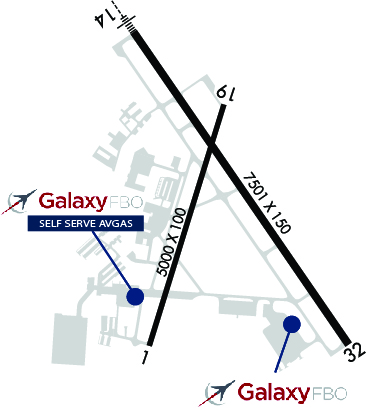

Sunrise / Sunset times for CONROE/NORTH HOUSTON RGNL

DateSunriseSunset
04/24/24 Wednesday6:4419:56
04/25/24 Thursday6:4319:56
04/26/24 Friday6:4219:57
04/27/24 Saturday6:4119:58
04/28/24 Sunday6:4019:58
04/29/24 Monday6:3919:59
04/30/24 Tuesday6:3819:59
05/01/24 Wednesday6:3820:00
05/02/24 Thursday6:3720:01
05/03/24 Friday6:3620:01
05/04/24 Saturday6:3520:02
05/05/24 Sunday6:3420:03
05/06/24 Monday6:3320:03
05/07/24 Tuesday6:3320:04

Airport Facilities

Airport Attendance ScheduleSAT-SUN 0800-1600, MON-FRI 0800-1700
Airport Status OPERATIONAL (This Status can change at any time - please check NOTAMS)
Airport Lighting ScheduleHIRL RWY 14/32 PRESET LOW INTST; TO INCR INTST & ACTVT REIL RWY 32 - CTAF.
Airport Storage AvailableTie Downs, Hanger
Extra Services AvailableAvionics, Charter, Flight Instruction, Aircraft Rental
Wind IndicatorYES - (lighted)
Control TowerYES
CTAF Frequency124.125
Unicom Frequency
Rotating Beacon ColorWG
Segmented CircleYES
Landing FeeNO

Airport Inspection Data

Airport InspectedSTATE - performed by STATE AERONAUTICAL PERSONNEL
Inspection Date04/10/2023

Airport Services

Type of Fuel AvailableGrade 100LL, JET A (freeze point -40C)
Airframe Repair ServiceMAJOR
Power Plant Repair ServiceMAJOR

Geographic Data

LatitudeN3021.2
LongitudeW09524.9 (ESTIMATED)
Arpt Elevation244ft (SURVEYED)
Magnetic Variation05E
37 miles Nof HOUSTON
Traffic Pattern Altitude
Sectional ChartHOUSTON

Aircraft Data

Operations (Reported)YearlyAvg. Daily
General Aviation Transient 66822183
General Aviation Local 48371133
Air Taxi 30448
Commerical 20
Commuter 00
Military 12333
Aircraft based on Field
General Aviation Singles 150
General Aviation Multi 26
Jet Aircraft 28
General Aviation Helicopters 8
Military Aircraft 24
Gliders 1
Ultralights 0

FAA Services

FSS on field NO
FSS tie-in MONTGOMERY COUNTY
FSS Phone 1-800-WX-BRIEF
Who issues Notams CXO
Notam D service at airport YES
ARTCC Name HOUSTON

Federal Status

Airport Certification
Aircraft Rescue & Firefighting IndexNone
Airport of EntryNo
Custom Landing RightsNo; US CUSTOMS USER FEE ARPT.
Joint Civil/MilitaryNo
Military Landing rightsYES

Federal Agreements

NATIONAL PLAN OF INTEGRATED AIRPORT SYSTEMS (NPIAS)
GRANT AGREEMENTS UNDER FAAP/ADAP/AIP
SURPLUS PROPERTY AGREEMENT UNDER PUBLIC LAW 289
ASSURANCES PURSUANT TO TITLE VI, CIVIL RIGHTS ACT OF 1964
AGREEMENT UNDER DLAND OR DCLA HAS EXPIRED.

Remarks

EXTSV MIL HEL ACTVY ON ARPT.
(A23) HELS USE RIGHT-HAND TFC.
AVOID NOISE SENSITIVE AREA 10 MI SW QUAD OF ARPT.
MIL SVC FUEL 0600-2100 C936-494-4252.
FOR CD WHEN ATCT CLSD CTC HOUSTON APCH AT 281-443-5844, TO CNL IFR AT 281-443-5888.
EXTV STUDENT PILOT (SUNRISE TO SUNSET).
Airport Communications & Frequencies:
ATIS Frequencies:   Hours(local) of Operation: CONTINUOUS
118.325
CONROE Tower Frequencies:   Hours(local) of operation: 0600-2100   
124.125
CONROE Ground Frequencies:
120.45
Clearance Delivery Frequencies:
120.45
119.55 WHEN TWR CLSD
CTAF Frequency:
124.125
HOUSTON Primary Approach Frequencies:  
119.7
281.4
HOUSTON Primary Departure Frequencies:  
119.7
281.4
Runway Identifications
Runway Identification: 01/19
Length: 5000 ft
Width: 100 ft
Surface: CONCRETE-GOOD CONDITION
Edge lights: Medium Intensity

Treatment: NONE

 Runway: 01   Runway: 19
Mag heading: 12°Mag heading: 192°
Rwy Slope: -.02% DownRwy Slope: .02% Up
Approach: Approach:
Pattern: Left TrafficPattern: Left Traffic
Markings: NONPRECISION INSTRUMENTMarkings: NONPRECISION INSTRUMENT
Marking Condition: GOODMarking Condition: GOOD
Arresting Dev: Arresting Dev:
Lat & Long: N3020.7  W09525.2Lat. & Long.: N3021.5  W09524.9
Elev: 229.6 ft. MSLElev: 228.7 ft. MSL
TCH: 49 ft. AGLTCH: 49 ft. AGL
Visual Glide Path: 3.15 degreesVisual Glide Path: 3.00 degrees
Displaced Threshold: NoDisplaced Threshold: No
Touchdown Zone: YESTouchdown Zone: YES
Touchdown Elev.: 236.7 feetTouchdown Elev.: 236.7 feet
Visual Glide Slope: 2-Light PAPI on LEFT side of RunwayVisual Glide Slope: 2-Light PAPI on LEFT side of Runway
RVR Equipment: RVR Equipment:
RVV Equipment: NORVV Equipment: NO
Approach Lights: Approach Lights:
REIL: NOREIL: NO
Centerline Lights: NOCenterline Lights: NO
Touchdown lights: NOTouchdown lights: NO
Runway Category: Runway with a Non-precision Approach having visibility minimums greater than 3/4 mileRunway Category: Runway with a Non-precision Approach having visibility minimums greater than 3/4 mile
Declared Distances: TORA:5000' TODA:5000' ASDA:5000' LDA:5000'Declared Distances: TORA:5000' TODA:5000' ASDA:5000' LDA:5000'
Obstructions: TREESObstructions: TREES
Marked: NOT Marked/LightedMarked: NOT Marked/Lighted
Clearance slope: 20:1Clearance slope: 24:1
Obstruction height: 56 feet AGLObstruction height: 50 feet AGL
Dist. from runway: 1350 feetDist. from runway: 1400 feet
Centerline offset: 460BCenterline offset: 460B
Comments: Comments:
Runway Identification: 14/32
Length: 7501 ft
Width: 150 ft
Surface: CONCRETE-GOOD CONDITION
Edge lights: High Intensity

Treatment: NONE
Weight: PCN 36 /R/B/W/T

 Runway: 14   Runway: 32
Mag heading: 140°Mag heading: 320°
Rwy Slope: .09% UpRwy Slope: -.09% Down
Approach: ILS/DMEApproach:
Pattern: Left TrafficPattern: Left Traffic
Markings: PRECISION INSTRUMENTMarkings: NONPRECISION INSTRUMENT
Marking Condition: GOODMarking Condition: GOOD
Arresting Dev: Arresting Dev:
Lat & Long: N3021.8  W09525.2Lat. & Long.: N3020.7  W09524.4
Elev: 234.1 ft. MSLElev: 241.1 ft. MSL
TCH: 47 ft. AGLTCH: 50 ft. AGL
Visual Glide Path: 3.00 degreesVisual Glide Path: 3.00 degrees
Displaced Threshold: NoDisplaced Threshold: No
Touchdown Zone: YESTouchdown Zone: YES
Touchdown Elev.: 235.9 feetTouchdown Elev.: 244.8 feet
Visual Glide Slope: 4-Light PAPI on LEFT side of RunwayVisual Glide Slope: 2-Light PAPI on LEFT side of Runway
RVR Equipment: RVR Equipment:
RVV Equipment: NORVV Equipment: NO
Approach Lights: MALSR - 1,400 foot medium intensity approach lighting system with runway alignment indicator lightsApproach Lights:
REIL: NOREIL: YES
Centerline Lights: NOCenterline Lights: NO
Touchdown lights: NOTouchdown lights: NO
Runway Category: Precision Instrument RunwayRunway Category: Runway with a Non-precision Approach having visibility minimums greater than 3/4 mile
Declared Distances: Declared Distances:
Obstructions: TREESObstructions: Unknown
Marked: NOT Marked/LightedMarked: NOT Marked/Lighted
Clearance slope: 34:1Clearance slope: 34:1
Obstruction height: 73 feet AGLObstruction height: 59 feet AGL
Dist. from runway: 2700 feetDist. from runway: 2250 feet
Centerline offset: Centerline offset: 228 feet left of centerline
Comments: Comments:
C:93/P: