Current Weather/Notams (Metars, TAFs, Notams, NWS Forecast, PIREPS, and nearby weather)
Customs Information Send updates to Support@FltPlan.com
Phone 859-282-6308
Fax N/A
Comments Mon-Fri 0800-1630 *2 hrs advance notice required *Maximum passengers per flight: 15 *Call prior to 1700 on preceeding weekday
Database effective 04/18/2024
Airport Diagram might not be current.
|
| Facility Name: | CINCINNATI/NORTHERN KENTUCKY INTL |
| City Name: | COVINGTON |
| County: | BOONE |
| State abbrev: | KY |
| State Name: | KENTUCKY |
| | |
| Ownership: | PUBLICLY OWNED |
| Use: | OPEN TO THE PUBLIC |
| Owner's Name: | KENTON COUNTY ARPT BOARD |
| Address: | PO BOX 752000 |
| | CINCINNATI, OH 45275-2000 |
| Owner's Phone: | 859-767-3151 |
| | |
| Manager's Name: | CANDACE MCGRAW |
| Address: | PO BOX 752000 |
| | CINCINNATI, OH 45275-2000 |
| Phone: | 859-767-3151 |
| | |
| FAA Region: | SOUTHERN |
| FAA Field Office: | MEM |
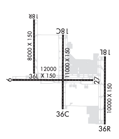
Runway Identifications
Runway Identification: 09/27Length: 12001 ft
Width: 150 ft
Surface: CONCRETE ASPHALT-GOOD CONDITION
Edge lights: High IntensityTreatment: GROOVED
Weight: PCN 101/R/B/W/T
| | Runway: 09 | | Runway: 27 |
| Mag heading: | 96° | Mag heading: | 276° |
| Rwy Slope: | -.07% Down | Rwy Slope: | .07% Up |
| Approach: | ILS/DME | Approach: | ILS |
| Pattern: | Left Traffic | Pattern: | Left Traffic |
| Markings: | PRECISION INSTRUMENT | Markings: | PRECISION INSTRUMENT |
| Marking Condition: | GOOD | Marking Condition: | GOOD |
| Arresting Dev: | | Arresting Dev: | |
| Lat & Long: | N3902.8 W08441.7 | Lat. & Long.: | N3902.8 W08439.2 |
| Elev: | 883.3 ft. MSL | Elev: | 875.0 ft. MSL |
| TCH: | 70 ft. AGL | TCH: | 67 ft. AGL |
| Visual Glide Path: | 3.00 degrees | Visual Glide Path: | 3.00 degrees |
| Displaced Threshold: | No | Displaced Threshold: | No |
| Touchdown Zone: | YES | Touchdown Zone: | YES |
| Touchdown Elev.: | 883.3 feet | Touchdown Elev.: | 875.0 feet |
| Visual Glide Slope: | 4-Light PAPI on LEFT side of Runway | Visual Glide Slope: | 4-Light PAPI on LEFT side of Runway |
| RVR Equipment: | TOUCHDOWN-ROLLOUT | RVR Equipment: | TOUCHDOWN-ROLLOUT |
| RVV Equipment: | NO | RVV Equipment: | NO |
| Approach Lights: | MALSR - 1,400 foot medium intensity approach lighting system with runway alignment indicator lights | Approach Lights: | MALSR - 1,400 foot medium intensity approach lighting system with runway alignment indicator lights |
| REIL: | NO | REIL: | NO |
| Centerline Lights: | YES | Centerline Lights: | YES |
| Touchdown lights: | YES | Touchdown lights: | NO |
| Runway Category: | Precision Instrument Runway | Runway Category: | Precision Instrument Runway |
| Declared Distances: | TORA:12000' TODA:12000' ASDA:11640' LDA:11640' | Declared Distances: | TORA:12000' TODA:12000' ASDA:12000' LDA:12000' |
Runway Identification: 18C/36CLength: 11000 ft
Width: 150 ft
Surface: CONCRETE ASPHALT-GOOD CONDITION
Edge lights: High IntensityTreatment: GROOVED
Weight: PCN 112/F/C/W/T
| | Runway: 18C | | Runway: 36C |
| Mag heading: | 186° | Mag heading: | 6° |
| Rwy Slope: | -.31% Down | Rwy Slope: | .31% Up |
| Approach: | ILS/DME | Approach: | ILS/DME |
| Pattern: | Left Traffic | Pattern: | Left Traffic |
| Markings: | PRECISION INSTRUMENT | Markings: | PRECISION INSTRUMENT |
| Marking Condition: | GOOD | Marking Condition: | GOOD |
| Arresting Dev: | | Arresting Dev: | |
| Lat & Long: | N3903.9 W08440.1 | Lat. & Long.: | N3902.1 W08440.1 |
| Elev: | 874.6 ft. MSL | Elev: | 840.7 ft. MSL |
| TCH: | 71 ft. AGL | TCH: | 77 ft. AGL |
| Visual Glide Path: | 3.00 degrees | Visual Glide Path: | 3.00 degrees |
| Displaced Threshold: | No | Displaced Threshold: | No |
| Touchdown Zone: | YES | Touchdown Zone: | YES |
| Touchdown Elev.: | 874.6 feet | Touchdown Elev.: | 850.3 feet |
| Visual Glide Slope: | 4-Light PAPI on RIGHT side of Runway | Visual Glide Slope: | 4-Light PAPI on LEFT side of Runway |
| RVR Equipment: | TOUCHDOWN-MIDFIELD-ROLLOUT | RVR Equipment: | TOUCHDOWN-MIDFIELD-ROLLOUT |
| RVV Equipment: | NO | RVV Equipment: | NO |
| Approach Lights: | MALSR - 1,400 foot medium intensity approach lighting system with runway alignment indicator lights | Approach Lights: | ALSF2 - standard 2,400 foot high intensity approach lighting system with sequenced flashers, Category II or III |
| REIL: | NO | REIL: | NO |
| Centerline Lights: | YES | Centerline Lights: | YES |
| Touchdown lights: | YES | Touchdown lights: | YES |
| Runway Category: | Precision Instrument Runway | Runway Category: | Precision Instrument Runway |
| Declared Distances: | | Declared Distances: | |
Runway Identification: 18L/36RLength: 10000 ft
Width: 150 ft
Surface: CONCRETE-GOOD CONDITION
Edge lights: High IntensityTreatment: GROOVED
Weight: PCN 127/R/B/W/T
| | Runway: 18L | | Runway: 36R |
| Mag heading: | 186° | Mag heading: | 6° |
| Rwy Slope: | .10% Up | Rwy Slope: | -.10% Down |
| Approach: | ILS/DME | Approach: | ILS/DME |
| Pattern: | Left Traffic | Pattern: | Left Traffic |
| Markings: | PRECISION INSTRUMENT | Markings: | PRECISION INSTRUMENT |
| Marking Condition: | GOOD | Marking Condition: | GOOD |
| Arresting Dev: | | Arresting Dev: | |
| Lat & Long: | N3903.4 W08438.8 | Lat. & Long.: | N3901.7 W08438.8 |
| Elev: | 886.3 ft. MSL | Elev: | 896.1 ft. MSL |
| TCH: | 71 ft. AGL | TCH: | 70 ft. AGL |
| Visual Glide Path: | 3.00 degrees | Visual Glide Path: | 3.00 degrees |
| Displaced Threshold: | No | Displaced Threshold: | No |
| Touchdown Zone: | YES | Touchdown Zone: | YES |
| Touchdown Elev.: | 889.1 feet | Touchdown Elev.: | 896.1 feet |
| Visual Glide Slope: | 4-Light PAPI on LEFT side of Runway | Visual Glide Slope: | 4-Light PAPI on RIGHT side of Runway |
| RVR Equipment: | TOUCHDOWN-MIDFIELD-ROLLOUT | RVR Equipment: | TOUCHDOWN-MIDFIELD-ROLLOUT |
| RVV Equipment: | NO | RVV Equipment: | NO |
| Approach Lights: | MALSR - 1,400 foot medium intensity approach lighting system with runway alignment indicator lights | Approach Lights: | ALSF2 - standard 2,400 foot high intensity approach lighting system with sequenced flashers, Category II or III |
| REIL: | NO | REIL: | NO |
| Centerline Lights: | YES | Centerline Lights: | YES |
| Touchdown lights: | YES | Touchdown lights: | YES |
| Runway Category: | Precision Instrument Runway | Runway Category: | Precision Instrument Runway |
| Declared Distances: | | Declared Distances: | |
Runway Identification: 18R/36LLength: 8000 ft
Width: 150 ft
Surface: CONCRETE-GOOD CONDITION
Edge lights: High IntensityTreatment: GROOVED
Weight: PCN 170/R/B/W/T
| | Runway: 18R | | Runway: 36L |
| Mag heading: | 186° | Mag heading: | 6° |
| Rwy Slope: | .10% Up | Rwy Slope: | -.10% Down |
| Approach: | ILS/DME | Approach: | ILS/DME |
| Pattern: | Left Traffic | Pattern: | Left Traffic |
| Markings: | PRECISION INSTRUMENT | Markings: | PRECISION INSTRUMENT |
| Marking Condition: | GOOD | Marking Condition: | GOOD |
| Arresting Dev: | | Arresting Dev: | |
| Lat & Long: | N3904.3 W08441.0 | Lat. & Long.: | N3902.9 W08441.0 |
| Elev: | 864.7 ft. MSL | Elev: | 872.6 ft. MSL |
| TCH: | | TCH: | |
| Visual Glide Path: | | Visual Glide Path: | |
| Displaced Threshold: | No | Displaced Threshold: | No |
| Touchdown Zone: | YES | Touchdown Zone: | YES |
| Touchdown Elev.: | 867.8 feet | Touchdown Elev.: | 872.7 feet |
| Visual Glide Slope: | | Visual Glide Slope: | |
| RVR Equipment: | TOUCHDOWN-MIDFIELD-ROLLOUT | RVR Equipment: | TOUCHDOWN-MIDFIELD-ROLLOUT |
| RVV Equipment: | NO | RVV Equipment: | NO |
| Approach Lights: | ALSF2 - standard 2,400 foot high intensity approach lighting system with sequenced flashers, Category II or III | Approach Lights: | ALSF2 - standard 2,400 foot high intensity approach lighting system with sequenced flashers, Category II or III |
| REIL: | NO | REIL: | NO |
| Centerline Lights: | YES | Centerline Lights: | YES |
| Touchdown lights: | YES | Touchdown lights: | YES |
| Runway Category: | Precision Instrument Runway | Runway Category: | Precision Instrument Runway |
| Declared Distances: | | Declared Distances: | |

