Current Weather/Notams (Metars, TAFs, Notams, NWS Forecast, PIREPS, and nearby weather)
Customs Information Send updates to Support@FltPlan.com
Customs Not Available
Database effective 04/18/2024
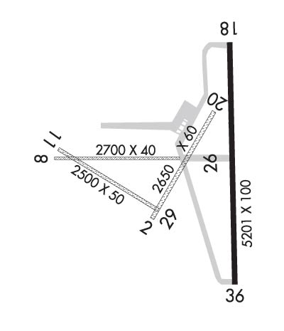
Airport Diagram might not be current. Facility Name: CUSHING MUNI City Name: CUSHING County: PAYNE State abbrev: OK State Name: OKLAHOMA Ownership: PUBLICLY OWNED Use: OPEN TO THE PUBLIC Owner's Name: CITY OF CUSHING Address: PO BOX 311 CUSHING, OK 74023 Owner's Phone: 918-225-2394 Manager's Name: MIKE MIDDLETON Address: 2414 TOM MALONEY DR CUSHING, OK 74023 Phone: 918-225-0881 FAA Region: SOUTHWEST FAA Field Office: AOK
Runway Identifications Help
Runway Identification: 02/20 Length: 2650 ftWidth: 60 ftSurface: GRASS-GOOD CONDITIONEdge lights: Treatment: NONE Runway: 02 Runway: 20 Mag heading: 26° Mag heading: 206° Rwy Slope: .53% Up Rwy Slope: -.53% Down Approach: Approach: Pattern: Left Traffic Pattern: Left Traffic Markings: NONSTANDARD Markings: NONSTANDARD Marking Condition: GOOD Marking Condition: GOOD Arresting Dev: Arresting Dev: Lat & Long: N3556.8 W09646.5 Lat. & Long.: N3557.2 W09646.2 Elev: 891.1 ft. MSL Elev: 905.1 ft. MSL TCH: TCH: Visual Glide Path: Visual Glide Path: Displaced Threshold: No Displaced Threshold: No Touchdown Zone: YES Touchdown Zone: YES Touchdown Elev.: 905.1 feet Touchdown Elev.: 905.1 feet Visual Glide Slope: Visual Glide Slope: RVR Equipment: RVR Equipment: RVV Equipment: NO RVV Equipment: NO Approach Lights: Approach Lights: REIL: NO REIL: NO Centerline Lights: NO Centerline Lights: NO Touchdown lights: NO Touchdown lights: NO Runway Category: Runway with a Visual Approach Runway Category: Runway with a Visual Approach Declared Distances: Declared Distances: Obstructions: TREES Obstructions: Marked: NOT Marked/Lighted Marked: Clearance slope: 15:1 Clearance slope: 20:1 Obstruction height: 35 feet AGL Obstruction height: Dist. from runway: 528 feet Dist. from runway: Centerline offset: Centerline offset: Comments: Comments:
Runway Identification: 08/26 Length: 2700 ftWidth: 40 ftSurface: GRASS-GOOD CONDITIONEdge lights: Treatment: NONE Runway: 08 Runway: 26 Mag heading: 85° Mag heading: 265° Rwy Slope: -.86% Down Rwy Slope: .86% Up Approach: Approach: Pattern: Left Traffic Pattern: Left Traffic Markings: NONSTANDARD Markings: NONSTANDARD Marking Condition: GOOD Marking Condition: GOOD Arresting Dev: Arresting Dev: Lat & Long: N3557.0 W09646.9 Lat. & Long.: N3557.0 W09646.4 Elev: 923.8 ft. MSL Elev: 900.6 ft. MSL TCH: TCH: Visual Glide Path: Visual Glide Path: Displaced Threshold: No Displaced Threshold: No Touchdown Zone: YES Touchdown Zone: YES Touchdown Elev.: 923.8 feet Touchdown Elev.: 923.8 feet Visual Glide Slope: Visual Glide Slope: RVR Equipment: RVR Equipment: RVV Equipment: NO RVV Equipment: NO Approach Lights: Approach Lights: REIL: NO REIL: NO Centerline Lights: NO Centerline Lights: NO Touchdown lights: NO Touchdown lights: NO Runway Category: Runway with a Visual Approach Runway Category: Runway with a Visual Approach Declared Distances: Declared Distances: Obstructions: TREES Obstructions: Marked: NOT Marked/Lighted Marked: Clearance slope: 12:1 Clearance slope: 20:1 Obstruction height: 32 feet AGL Obstruction height: Dist. from runway: 387 feet Dist. from runway: Centerline offset: Centerline offset: Comments: Comments:
Runway Identification: 11/29 Length: 2500 ftWidth: 50 ftSurface: GRASS-GOOD CONDITIONEdge lights: Treatment: NONE Runway: 11 Runway: 29 Mag heading: 117° Mag heading: 297° Rwy Slope: -1.36% Down Rwy Slope: 1.36% Up Approach: Approach: Pattern: Left Traffic Pattern: Left Traffic Markings: NONSTANDARD Markings: NONSTANDARD Marking Condition: GOOD Marking Condition: GOOD Arresting Dev: Arresting Dev: Lat & Long: N3557.1 W09646.9 Lat. & Long.: N3556.8 W09646.5 Elev: 925.1 ft. MSL Elev: 891.0 ft. MSL TCH: TCH: Visual Glide Path: Visual Glide Path: Displaced Threshold: No Displaced Threshold: No Touchdown Zone: YES Touchdown Zone: YES Touchdown Elev.: 925.1 feet Touchdown Elev.: 925.1 feet Visual Glide Slope: Visual Glide Slope: RVR Equipment: RVR Equipment: RVV Equipment: NO RVV Equipment: NO Approach Lights: Approach Lights: REIL: NO REIL: NO Centerline Lights: NO Centerline Lights: NO Touchdown lights: NO Touchdown lights: NO Runway Category: Runway with a Visual Approach Runway Category: Runway with a Visual Approach Declared Distances: Declared Distances: Obstructions: TREES Obstructions: Marked: NOT Marked/Lighted Marked: Clearance slope: 11:1 Clearance slope: 20:1 Obstruction height: 42 feet AGL Obstruction height: Dist. from runway: 475 feet Dist. from runway: Centerline offset: Centerline offset: Comments: Comments:
Runway Identification: 18/36 Length: 5201 ftWidth: 100 ftSurface: CONCRETE-GOOD CONDITIONEdge lights: Medium Intensity Treatment: GROOVEDWeight: PCN 4 /R/B/X/T Runway: 18 Runway: 36 Mag heading: 175° Mag heading: 355° Rwy Slope: -.72% Down Rwy Slope: .72% Up Approach: Approach: Pattern: Left Traffic Pattern: Left Traffic Markings: NONPRECISION INSTRUMENT Markings: NONPRECISION INSTRUMENT Marking Condition: FAIR Marking Condition: FAIR Arresting Dev: Arresting Dev: Lat & Long: N3557.4 W09646.2 Lat. & Long.: N3556.6 W09646.1 Elev: 916.0 ft. MSL Elev: 878.7 ft. MSL TCH: 26 ft. AGL TCH: 33 ft. AGL Visual Glide Path: 3.00 degrees Visual Glide Path: 3.00 degrees Displaced Threshold: No Displaced Threshold: No Touchdown Zone: YES Touchdown Zone: YES Touchdown Elev.: 916.0 feet Touchdown Elev.: 900.9 feet Visual Glide Slope: 4-Light PAPI on LEFT side of Runway Visual Glide Slope: 4-Light PAPI on LEFT side of Runway RVR Equipment: RVR Equipment: RVV Equipment: NO RVV Equipment: NO Approach Lights: Approach Lights: REIL: YES REIL: YES Centerline Lights: NO Centerline Lights: NO Touchdown lights: NO Touchdown lights: NO Runway Category: Runway with a Non-precision Approach having visibility minimums greater than 3/4 mile Runway Category: Runway with a Non-precision Approach having visibility minimums greater than 3/4 mile Declared Distances: TORA:5201' TODA:5201' ASDA:4986' LDA:4986' Declared Distances: TORA:5201' TODA:5201' ASDA:5201' LDA:4986' Obstructions: Obstructions: TREES Marked: Marked: NOT Marked/Lighted Clearance slope: 20:1 Clearance slope: 23:1 Obstruction height: Obstruction height: 50 feet AGL Dist. from runway: Dist. from runway: 1373 feet Centerline offset: Centerline offset: 48 feet right of centerline Comments: Comments: