Current Weather/Notams (Metars, TAFs, Notams, NWS Forecast, PIREPS, and nearby weather)
Customs Information Send updates to Support@FltPlan.com
Customs Not Available
Database effective 05/16/2024
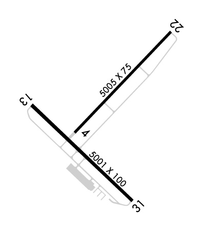
Airport Diagram might not be current.
|
| Facility Name: | CROSS CITY |
| City Name: | CROSS CITY |
| County: | DIXIE |
| State abbrev: | FL |
| State Name: | FLORIDA |
| | |
| Ownership: | PUBLICLY OWNED |
| Use: | OPEN TO THE PUBLIC |
| Owner's Name: | DIXIE COUNTY; CONTACT PERSON: MIKE CASSIDY, 352-498-1426 FAX: 352-498-1207 |
| Address: | COUNTY COURTHOUSE P.O. BOX 2600, P.O. BOX 2600 |
| | CROSS CITY, FL 32628 |
| Owner's Phone: | 352-498-1206 |
| | |
| Manager's Name: | CLINT BEAUCHAMP; AIRPORT PHYSICAL ADDRESS: 1516 AIRPORT ROAD., CROSS CITY, FL 32628, 352-498-1200 |
| Address: | CROSS CITY AIRPORT, 508 NE 241 ST |
| | CROSS CITY, FL 32628 |
| Phone: | 352-498-6656 |
| | |
| FAA Region: | SOUTHERN |
| FAA Field Office: | ORL |
Runway Identifications
Runway Identification: 04/22Length: 5005 ft
Width: 75 ft
Surface: ASPHALT-FAIR CONDITION
Edge lights: Medium IntensityTreatment: NONE
Weight: PCN 8 /F/B/Y/T
| | Runway: 04 | | Runway: 22 |
| Mag heading: | 49° | Mag heading: | 229° |
| Rwy Slope: | -.05% Down | Rwy Slope: | .05% Up |
| Approach: | | Approach: | |
| Pattern: | Left Traffic | Pattern: | Left Traffic |
| Markings: | NONPRECISION INSTRUMENT | Markings: | NONPRECISION INSTRUMENT |
| Marking Condition: | POOR | Marking Condition: | POOR |
| Arresting Dev: | | Arresting Dev: | |
| Lat & Long: | N2938.0 W08306.5 | Lat. & Long.: | N2938.6 W08305.8 |
| Elev: | 41.7 ft. MSL | Elev: | 39.3 ft. MSL |
| TCH: | 52 ft. AGL | TCH: | 56 ft. AGL |
| Visual Glide Path: | 3.00 degrees | Visual Glide Path: | 3.00 degrees |
| Displaced Threshold: | No | Displaced Threshold: | No |
| Touchdown Zone: | YES | Touchdown Zone: | YES |
| Touchdown Elev.: | 41.9 feet | Touchdown Elev.: | 42.1 feet |
| Visual Glide Slope: | 2-Light PAPI on LEFT side of Runway | Visual Glide Slope: | 2-Light PAPI on LEFT side of Runway |
| RVR Equipment: | | RVR Equipment: | |
| RVV Equipment: | NO | RVV Equipment: | NO |
| Approach Lights: | | Approach Lights: | |
| REIL: | NO | REIL: | NO |
| Centerline Lights: | NO | Centerline Lights: | NO |
| Touchdown lights: | NO | Touchdown lights: | NO |
| Runway Category: | Runway with a Visual Approach | Runway Category: | Runway with a Visual Approach |
| Declared Distances: | | Declared Distances: | |
| Obstructions: | TREES | Obstructions: | TREES |
| Marked: | NOT Marked/Lighted | Marked: | NOT Marked/Lighted |
| Clearance slope: | 21:1 | Clearance slope: | 17:1 |
| Obstruction height: | 55 feet AGL | Obstruction height: | 63 feet AGL |
| Dist. from runway: | 1355 feet | Dist. from runway: | 1270 feet |
| Centerline offset: | 150 right of centerline | Centerline offset: | 60 feet left of centerline |
| Comments: | | Comments: | |
Runway Identification: 13/31Length: 5001 ft
Width: 100 ft
Surface: CONCRETE ASPHALT-GOOD CONDITION
Edge lights: Medium IntensityTreatment: NONE
Weight: PCN 10 /R/C/W/T
| | Runway: 13 | | Runway: 31 |
| Mag heading: | 139° | Mag heading: | 319° |
| Rwy Slope: | -.01% Down | Rwy Slope: | .01% Up |
| Approach: | | Approach: | |
| Pattern: | Left Traffic | Pattern: | Left Traffic |
| Markings: | NONPRECISION INSTRUMENT | Markings: | NONPRECISION INSTRUMENT |
| Marking Condition: | FAIR | Marking Condition: | FAIR |
| Arresting Dev: | | Arresting Dev: | |
| Lat & Long: | N2938.2 W08306.8 | Lat. & Long.: | N2937.6 W08306.1 |
| Elev: | 41.0 ft. MSL | Elev: | 40.6 ft. MSL |
| TCH: | 37 ft. AGL | TCH: | 36 ft. AGL |
| Visual Glide Path: | 3.00 degrees | Visual Glide Path: | 3.00 degrees |
| Displaced Threshold: | No | Displaced Threshold: | No |
| Touchdown Zone: | YES | Touchdown Zone: | YES |
| Touchdown Elev.: | 41.9 feet | Touchdown Elev.: | 41.8 feet |
| Visual Glide Slope: | 2-Light PAPI on LEFT side of Runway | Visual Glide Slope: | 2-Light PAPI on LEFT side of Runway |
| RVR Equipment: | | RVR Equipment: | |
| RVV Equipment: | NO | RVV Equipment: | NO |
| Approach Lights: | | Approach Lights: | |
| REIL: | YES | REIL: | YES |
| Centerline Lights: | NO | Centerline Lights: | NO |
| Touchdown lights: | NO | Touchdown lights: | NO |
| Runway Category: | Runway with a Visual Approach | Runway Category: | Runway with a Non-precision Approach having visibility minimums greater than 3/4 mile |
| Declared Distances: | | Declared Distances: | |
| Obstructions: | TREES | Obstructions: | TREES |
| Marked: | NOT Marked/Lighted | Marked: | NOT Marked/Lighted |
| Clearance slope: | 22:1 | Clearance slope: | |
| Obstruction height: | 56 feet AGL | Obstruction height: | 20 feet AGL |
| Dist. from runway: | 1430 feet | Dist. from runway: | 200 feet |
| Centerline offset: | 250 right of centerline | Centerline offset: | 250 feet left of centerline |
| Comments: | | Comments: | RWY 31 TREES 160 FT - 200 FT FROM THE RWY END 250 FT LEFT OF CNTRLN. |

