Current Weather/Notams (Metars, TAFs, Notams, NWS Forecast, PIREPS, and nearby weather)
Customs Information Send updates to Support@FltPlan.com
Customs Not Available
Database effective 05/16/2024
Airport Diagram might not be current.
|
| Facility Name: | INGERSOLL |
| City Name: | CANTON |
| County: | FULTON |
| State abbrev: | IL |
| State Name: | ILLINOIS |
| | |
| Ownership: | PUBLICLY OWNED |
| Use: | OPEN TO THE PUBLIC |
| Owner's Name: | CANTON PARK DISTRICT |
| Address: | 250 S AVE D |
| | CANTON, IL 61520 |
| Owner's Phone: | 309-647-1345 |
| | |
| Manager's Name: | JON JOHNSON |
| Address: | 250 S AVE D; EMAIL ADDRESS: CPD_JOHNSON@SBCGLOBAL.NET (ALL LOWER CASE) |
| | CANTON, IL 61520 |
| Phone: | 309-647-1345 |
| | |
| FAA Region: | GREAT LAKES |
| FAA Field Office: | CHI |
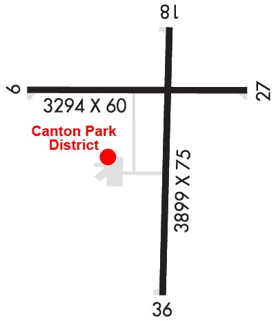
Runway Identifications
Runway Identification: 09/27Length: 3294 ft
Width: 60 ft
Surface: ASPHALT-GOOD CONDITION
Edge lights: Medium IntensityTreatment: NONE
| | Runway: 09 | | Runway: 27 |
| Mag heading: | 87° | Mag heading: | 267° |
| Rwy Slope: | -.06% Down | Rwy Slope: | .06% Up |
| Approach: | | Approach: | |
| Pattern: | Left Traffic | Pattern: | Left Traffic |
| Markings: | BASIC | Markings: | BASIC |
| Marking Condition: | FAIR | Marking Condition: | FAIR |
| Arresting Dev: | | Arresting Dev: | |
| Lat & Long: | N4034.2 W09004.9 | Lat. & Long.: | N4034.2 W09004.2 |
| Elev: | 683.8 ft. MSL | Elev: | 681.8 ft. MSL |
| TCH: | | TCH: | |
| Visual Glide Path: | | Visual Glide Path: | |
| Displaced Threshold: | No | Displaced Threshold: | No |
| Touchdown Zone: | YES | Touchdown Zone: | YES |
| Touchdown Elev.: | 683.9 feet | Touchdown Elev.: | 683.4 feet |
| Visual Glide Slope: | | Visual Glide Slope: | |
| RVR Equipment: | | RVR Equipment: | |
| RVV Equipment: | NO | RVV Equipment: | NO |
| Approach Lights: | | Approach Lights: | |
| REIL: | NO | REIL: | NO |
| Centerline Lights: | NO | Centerline Lights: | NO |
| Touchdown lights: | NO | Touchdown lights: | NO |
| Runway Category: | Runway with a Visual Approach | Runway Category: | Runway with a Visual Approach |
| Declared Distances: | | Declared Distances: | |
| Obstructions: | | Obstructions: | TREES |
| Marked: | | Marked: | NOT Marked/Lighted |
| Clearance slope: | 20:1 | Clearance slope: | 14:1 |
| Obstruction height: | | Obstruction height: | 30 feet AGL |
| Dist. from runway: | | Dist. from runway: | 630 feet |
| Centerline offset: | | Centerline offset: | 110 feet left of centerline |
| Comments: | | Comments: | |
Runway Identification: 18/36Length: 3899 ft
Width: 75 ft
Surface: ASPHALT-GOOD CONDITION
Edge lights: Medium IntensityTreatment: NONE
| | Runway: 18 | | Runway: 36 |
| Mag heading: | 179° | Mag heading: | 359° |
| Rwy Slope: | -.30% Down | Rwy Slope: | .30% Up |
| Approach: | | Approach: | |
| Pattern: | Left Traffic | Pattern: | Left Traffic |
| Markings: | NONPRECISION INSTRUMENT | Markings: | NONPRECISION INSTRUMENT |
| Marking Condition: | FAIR | Marking Condition: | FAIR |
| Arresting Dev: | | Arresting Dev: | |
| Lat & Long: | N4034.4 W09004.4 | Lat. & Long.: | N4033.7 W09004.4 |
| Elev: | 681.9 ft. MSL | Elev: | 670.3 ft. MSL |
| TCH: | | TCH: | |
| Visual Glide Path: | | Visual Glide Path: | |
| Displaced Threshold: | No | Displaced Threshold: | No |
| Touchdown Zone: | YES | Touchdown Zone: | YES |
| Touchdown Elev.: | 682.1 feet | Touchdown Elev.: | 679.6 feet |
| Visual Glide Slope: | | Visual Glide Slope: | |
| RVR Equipment: | | RVR Equipment: | |
| RVV Equipment: | NO | RVV Equipment: | NO |
| Approach Lights: | | Approach Lights: | |
| REIL: | NO | REIL: | YES |
| Centerline Lights: | NO | Centerline Lights: | NO |
| Touchdown lights: | NO | Touchdown lights: | NO |
| Runway Category: | Runway with a Non-precision Approach | Runway Category: | Runway with a Non-precision Approach |
| Declared Distances: | | Declared Distances: | |