Current Weather/Notams (Metars, TAFs, Notams, NWS Forecast, PIREPS, and nearby weather)
Customs Information Send updates to Support@FltPlan.com
Customs Not Available
Database effective 05/16/2024
Airport Diagram might not be current.
|
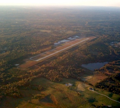
| Facility Name: | WEST GEORGIA RGNL - O V GRAY FLD |
| City Name: | CARROLLTON |
| County: | CARROLL |
| State abbrev: | GA |
| State Name: | GEORGIA |
| | |
| Ownership: | PUBLICLY OWNED |
| Use: | OPEN TO THE PUBLIC |
| Owner's Name: | WEST GA ARPT AUTH |
| Address: | 635 REGIONAL AIRPORT ROAD |
| | CARROLLTON, GA 30117 |
| Owner's Phone: | 770-354-5927 |
| | |
| Manager's Name: | SUSAN HEATH |
| Address: | 635 REGIONAL AIRPORT ROAD |
| | CARROLLTON, GA 30117 |
| Phone: | 770-354-5927 |
| | |
| FAA Region: | SOUTHERN |
| FAA Field Office: | ATL |
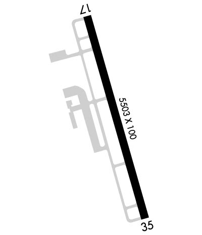
Runway Identifications
Runway Identification: 17/35Length: 5503 ft
Width: 100 ft
Surface: ASPHALT-GOOD CONDITION
Edge lights: High IntensityTreatment: NONE
| | Runway: 17 | | Runway: 35 |
| Mag heading: | 168° | Mag heading: | 348° |
| Rwy Slope: | -.98% Down | Rwy Slope: | .98% Up |
| Approach: | | Approach: | LOC/GS |
| Pattern: | Left Traffic | Pattern: | Left Traffic |
| Markings: | NONPRECISION INSTRUMENT | Markings: | PRECISION INSTRUMENT |
| Marking Condition: | GOOD | Marking Condition: | GOOD |
| Arresting Dev: | | Arresting Dev: | |
| Lat & Long: | N3338.3 W08509.3 | Lat. & Long.: | N3337.5 W08509.0 |
| Elev: | 1164.4 ft. MSL | Elev: | 1110.2 ft. MSL |
| TCH: | 44 ft. AGL | TCH: | 54 ft. AGL |
| Visual Glide Path: | 3.00 degrees | Visual Glide Path: | 3.00 degrees |
| Displaced Threshold: | No | Displaced Threshold: | No |
| Touchdown Zone: | YES | Touchdown Zone: | YES |
| Touchdown Elev.: | 1164.4 feet | Touchdown Elev.: | 1140.1 feet |
| Visual Glide Slope: | 4-Light PAPI on LEFT side of Runway | Visual Glide Slope: | 4-Light PAPI on LEFT side of Runway |
| RVR Equipment: | | RVR Equipment: | |
| RVV Equipment: | NO | RVV Equipment: | NO |
| Approach Lights: | | Approach Lights: | |
| REIL: | NO | REIL: | NO |
| Centerline Lights: | NO | Centerline Lights: | NO |
| Touchdown lights: | NO | Touchdown lights: | NO |
| Runway Category: | Runway with a Non-precision Approach having visibility minimums greater than 3/4 mile | Runway Category: | Precision Instrument Runway |
| Declared Distances: | | Declared Distances: | |
| Obstructions: | TREES | Obstructions: | TREES |
| Marked: | NOT Marked/Lighted | Marked: | NOT Marked/Lighted |
| Clearance slope: | 23:1 | Clearance slope: | 22:1 |
| Obstruction height: | 92 feet AGL | Obstruction height: | 34 feet AGL |
| Dist. from runway: | 2341 feet | Dist. from runway: | 948 feet |
| Centerline offset: | 401 left of centerline | Centerline offset: | 575 feet right of centerline |
| Comments: | | Comments: | |