
| ||||||||||||||||||||||||||||||||||||||||||||
| ||||||||||||||||||||||||||||||||||||||||||||
| ||||||||||||||||||||||||||||||||||||||||||||
| Rwy | Rwy | |||||||
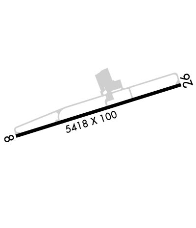
| 5423x100 | 5423' | 5423x100 | 5423' | 109.10 - 255° | ||||
| Runway ID | Single Wheel | Double Wheel | Double Tandem Wheel | Dual Double Wheel |
| 08/26 | 33,000 | 62,000 | N/A | N/A |
| These numbers are Advisory and are not limits. The Airport Manager should have more accurate Weight Limits | ||||
 Airport Diagram might not be current. | |
| Facility Name: | CROSSVILLE MEML-WHITSON FLD |
| City Name: | CROSSVILLE |
| County: | CUMBERLAND |
| State abbrev: | TN |
| State Name: | TENNESSEE |
| Ownership: | PUBLICLY OWNED |
| Use: | OPEN TO THE PUBLIC |
| Owner's Name: | CITY OF CROSSVILLE |
| Address: | 392 NORTH MAIN |
| CROSSVILLE, TN 38555 | |
| Owner's Phone: | 931-484-5278 |
| Manager's Name: | GREG LIVINGSTON |
| Address: | 2409 SPARTA HIGHWAY |
| CROSSVILLE, TN 38555 | |
| Phone: | 931-484-5278 |
| FAA Region: | SOUTHERN |
| FAA Field Office: | MEM |

| Date | Sunrise | Sunset |
|---|---|---|
| 04/18/24 Thursday | 6:02 | 19:17 |
| 04/19/24 Friday | 6:01 | 19:18 |
| 04/20/24 Saturday | 6:00 | 19:19 |
| 04/21/24 Sunday | 5:59 | 19:20 |
| 04/22/24 Monday | 5:57 | 19:21 |
| 04/23/24 Tuesday | 5:56 | 19:21 |
| 04/24/24 Wednesday | 5:55 | 19:22 |
| 04/25/24 Thursday | 5:54 | 19:23 |
| 04/26/24 Friday | 5:53 | 19:24 |
| 04/27/24 Saturday | 5:51 | 19:25 |
| 04/28/24 Sunday | 5:50 | 19:26 |
| 04/29/24 Monday | 5:49 | 19:26 |
| 04/30/24 Tuesday | 5:48 | 19:27 |
| 05/01/24 Wednesday | 5:47 | 19:28 |
| Airport Attendance Schedule | 7 Days A Week 0800-DARK; CLSD THANKSGIVING & CHRISTMAS. |
| Airport Status | OPERATIONAL (This Status can change at any time - please check NOTAMS) |
| Airport Lighting Schedule | HIRL RWY 08/26 PRESET LOW INTST; INCR INTST - CTAF. |
| Airport Storage Available | Tie Downs |
| Extra Services Available | Flight Instruction, Aircraft Rental, Aircraft Sales |
| Wind Indicator | YES - (lighted) |
| Control Tower | NO |
| CTAF Frequency | 122.700 |
| Unicom Frequency | 122.700 |
| Rotating Beacon Color | WG |
| Segmented Circle | YES |
| Landing Fee | NO |
| Airport Inspected | STATE - performed by STATE AERONAUTICAL PERSONNEL |
| Inspection Date | 04/14/2023 |
| Type of Fuel Available | Grade 100LL, JET A |
| Airframe Repair Service | MAJOR |
| Power Plant Repair Service | MAJOR |
| Latitude | N3557.1 |
| Longitude | W08505.1 (ESTIMATED) |
| Arpt Elevation | 1881ft (SURVEYED) |
| Magnetic Variation | 02W |
| 3 miles W | of CROSSVILLE |
| Traffic Pattern Altitude | |
| Sectional Chart | ATLANTA |
| Operations (Reported) | Yearly | Avg. Daily |
|---|---|---|
| General Aviation Transient | 13140 | 36 |
| General Aviation Local | 15000 | 41 |
| Air Taxi | 110 | 0 |
| Commerical | 0 | 0 |
| Commuter | 0 | 0 |
| Military | 300 | 1 |
| Aircraft based on Field | |
|---|---|
| General Aviation Singles | 37 |
| General Aviation Multi | 2 |
| Jet Aircraft | 0 |
| General Aviation Helicopters | 0 |
| Military Aircraft | 0 |
| Gliders | 0 |
| Ultralights | 0 |
| FSS on field | NO |
| FSS tie-in | NASHVILLE |
| FSS Phone | 1-800-WX-BRIEF |
| Who issues Notams | CSV |
| Notam D service at airport | YES |
| ARTCC Name | ATLANTA |
| Airport Certification | |
| Aircraft Rescue & Firefighting Index | None |
| Airport of Entry | No |
| Custom Landing Rights | No |
| Joint Civil/Military | No |
| Military Landing rights | YES |
| NATIONAL PLAN OF INTEGRATED AIRPORT SYSTEMS (NPIAS) |
| GRANT AGREEMENTS UNDER FAAP/ADAP/AIP |
| ASSURANCES PURSUANT TO TITLE VI, CIVIL RIGHTS ACT OF 1964 |
| FOR CD IF UNA TO CTC ON FSS FREQ, CTC ATLANTA ARTCC AT 770-210-7692. |
Airport Communications & Frequencies:
| |||||||||
| Runway: 08 | Runway: 26 | ||
| Mag heading: | 75° | Mag heading: | 255° |
| Rwy Slope: | -.26% Down | Rwy Slope: | .26% Up |
| Approach: | Approach: | ILS | |
| Pattern: | Left Traffic | Pattern: | Left Traffic |
| Markings: | PRECISION INSTRUMENT | Markings: | PRECISION INSTRUMENT |
| Marking Condition: | GOOD | Marking Condition: | GOOD |
| Arresting Dev: | Arresting Dev: | ||
| Lat & Long: | N3557.0 W08505.6 | Lat. & Long.: | N3557.2 W08504.6 |
| Elev: | 1880.9 ft. MSL | Elev: | 1866.9 ft. MSL |
| TCH: | 50 ft. AGL | TCH: | 60 ft. AGL |
| Visual Glide Path: | 3.00 degrees | Visual Glide Path: | 3.00 degrees |
| Displaced Threshold: | No | Displaced Threshold: | No |
| Touchdown Zone: | YES | Touchdown Zone: | YES |
| Touchdown Elev.: | 1881.7 feet | Touchdown Elev.: | 1870.9 feet |
| Visual Glide Slope: | 4-BOX VASI ON RIGHT SIDE OF RUNWAY | Visual Glide Slope: | 4-Light PAPI on LEFT side of Runway; PAPI UNUSBL BYD 8 DEGS RIGHT OF CNTRLN. |
| RVR Equipment: | RVR Equipment: | ||
| RVV Equipment: | NO | RVV Equipment: | NO |
| Approach Lights: | Approach Lights: | ||
| REIL: | NO | REIL: | YES |
| Centerline Lights: | NO | Centerline Lights: | NO |
| Touchdown lights: | NO | Touchdown lights: | NO |
| Runway Category: | Runway with a Visual Approach | Runway Category: | Precision Instrument Runway |
| Declared Distances: | Declared Distances: |