
| ||||||||||||||||||||||||||||||||
| ||||||||||||||||||||||||||||||||
| Rwy | Rwy | |||||||
| 2684x50 | 2684' | 2684x50 | 2684' | |||||
| Runway ID | Single Wheel | Double Wheel | Double Tandem Wheel | Dual Double Wheel |
| 18/36 | N/A | N/A | N/A | N/A |
| These numbers are Advisory and are not limits. The Airport Manager should have more accurate Weight Limits | ||||
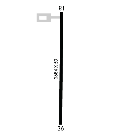 Airport Diagram might not be current. | |
| Facility Name: | CORNING MUNI |
| City Name: | CORNING |
| County: | ADAMS |
| State abbrev: | IA |
| State Name: | IOWA |
| Ownership: | PUBLICLY OWNED |
| Use: | OPEN TO THE PUBLIC |
| Owner's Name: | CITY OF CORNING |
| Address: | 601 6TH |
| CORNING, IA 50841 | |
| Owner's Phone: | 641-322-4230 |
| Manager's Name: | WAYNE PAGE |
| Address: | 601 6TH |
| CORNING, IA 50841 | |
| Phone: | 515-491-5508 |
| FAA Region: | CENTRAL |
| FAA Field Office: | NONE |
| Date | Sunrise | Sunset |
|---|---|---|
| 04/25/24 Thursday | 6:24 | 20:10 |
| 04/26/24 Friday | 6:23 | 20:11 |
| 04/27/24 Saturday | 6:21 | 20:12 |
| 04/28/24 Sunday | 6:20 | 20:13 |
| 04/29/24 Monday | 6:19 | 20:15 |
| 04/30/24 Tuesday | 6:17 | 20:16 |
| 05/01/24 Wednesday | 6:16 | 20:17 |
| 05/02/24 Thursday | 6:15 | 20:18 |
| 05/03/24 Friday | 6:14 | 20:19 |
| 05/04/24 Saturday | 6:12 | 20:20 |
| 05/05/24 Sunday | 6:11 | 20:21 |
| 05/06/24 Monday | 6:10 | 20:22 |
| 05/07/24 Tuesday | 6:09 | 20:23 |
| 05/08/24 Wednesday | 6:08 | 20:24 |
| Airport Attendance Schedule | UNATTENDED |
| Airport Status | OPERATIONAL (This Status can change at any time - please check NOTAMS) |
| Airport Lighting Schedule | ACTVT MIRL RY 18/36 - 122.8. |
| Airport Storage Available | Tie Downs |
| Extra Services Available | NONE |
| Wind Indicator | YES - (lighted) |
| Control Tower | NO |
| CTAF Frequency | 122.900 |
| Unicom Frequency | |
| Rotating Beacon Color | WG |
| Segmented Circle | NO |
| Landing Fee | NO |
| Airport Inspected | STATE - performed by STATE AERONAUTICAL PERSONNEL |
| Inspection Date | 04/01/2022 |
| Type of Fuel Available | Grade 100LL; -10SELF SERVICE FUEL AVBL 24 HOURS WITH CREDIT CARD |
| Airframe Repair Service | NONE |
| Power Plant Repair Service | NONE |
| Latitude | N4059.6 |
| Longitude | W09445.3 (ESTIMATED) |
| Arpt Elevation | 1274ft (SURVEYED) |
| Magnetic Variation | 04E |
| 1 miles W | of CORNING |
| Traffic Pattern Altitude | |
| Sectional Chart | OMAHA |
| Operations (Reported) | Yearly | Avg. Daily |
|---|---|---|
| General Aviation Transient | 750 | 2 |
| General Aviation Local | 1250 | 3 |
| Air Taxi | 0 | 0 |
| Commerical | 0 | 0 |
| Commuter | 0 | 0 |
| Military | 0 | 0 |
| Aircraft based on Field | |
|---|---|
| General Aviation Singles | 8 |
| General Aviation Multi | 0 |
| Jet Aircraft | 0 |
| General Aviation Helicopters | 0 |
| Military Aircraft | 0 |
| Gliders | 0 |
| Ultralights | 0 |
| FSS on field | NO |
| FSS tie-in | FORT DODGE |
| FSS Phone | 1-800-WX-BRIEF |
| Who issues Notams | FOD |
| Notam D service at airport | YES |
| ARTCC Name | MINNEAPOLIS |
| Airport Certification | |
| Aircraft Rescue & Firefighting Index | None |
| Airport of Entry | No |
| Custom Landing Rights | No |
| Joint Civil/Military | No |
| Military Landing rights | No |
| THIS AIRPORT HAS BEEN SURVEYED BY THE NATIONAL GEODETIC SURVEY. |
| CTN: SHARP DROP BOTH ENDS RWY 18/36. |
| DEER INVOF ARPT. |
| SNOW REMOVAL OPS DURG WINT MONTHS VIA CITY OF CORNING AT 641-322-4230. AFT HRS CALL 515-491-5508. |
| FOR CD CTC MINNEAPOLIS ARTCC AT 651-463-5588. |
Airport Communications & Frequencies:
| |||||||
| Runway: 18 | Runway: 36 | ||
| Mag heading: | 177° | Mag heading: | 357° |
| Rwy Slope: | -.97% Down | Rwy Slope: | .97% Up |
| Approach: | Approach: | ||
| Pattern: | Right Traffic | Pattern: | Left Traffic |
| Markings: | NONPRECISION INSTRUMENT | Markings: | NONPRECISION INSTRUMENT |
| Marking Condition: | FAIR | Marking Condition: | FAIR |
| Arresting Dev: | Arresting Dev: | ||
| Lat & Long: | N4059.9 W09445.3 | Lat. & Long.: | N4059.4 W09445.3 |
| Elev: | 1274.0 ft. MSL | Elev: | 1248.0 ft. MSL |
| TCH: | TCH: | ||
| Visual Glide Path: | Visual Glide Path: | ||
| Displaced Threshold: | No | Displaced Threshold: | No |
| Touchdown Zone: | YES | Touchdown Zone: | YES |
| Touchdown Elev.: | 1274.0 feet | Touchdown Elev.: | 1274.0 feet |
| Visual Glide Slope: | Visual Glide Slope: | ||
| RVR Equipment: | RVR Equipment: | ||
| RVV Equipment: | NO | RVV Equipment: | NO |
| Approach Lights: | Approach Lights: | ||
| REIL: | NO | REIL: | NO |
| Centerline Lights: | NO | Centerline Lights: | NO |
| Touchdown lights: | NO | Touchdown lights: | NO |
| Runway Category: | Runway with a Non-precision Approach | Runway Category: | Runway with a Visual Approach |
| Declared Distances: | Declared Distances: | ||
| Obstructions: | TREE | Obstructions: | |
| Marked: | NOT Marked/Lighted | Marked: | |
| Clearance slope: | 21:1 | Clearance slope: | 20:1 |
| Obstruction height: | 40 feet AGL | Obstruction height: | |
| Dist. from runway: | 1074 feet | Dist. from runway: | |
| Centerline offset: | 194 right of centerline | Centerline offset: | |
| Comments: | Comments: |
