KCRW

YEAGER
CHARLESTON
WV
Time Zone: Eastern
Lat: N 3822.6
Long: W 08135.6
Elev: 947
Var: +06
Longest Runway: 6715
Clr Del: 118.55
Dept. ATIS: 127.6
Arr. ATIS: 127.6
Ground: 121.8
Tower: 125.7

FBO & Flight Services info for KCRW

FBOs: Update your Fuel Prices

CAPITAL JET CTRPh: 304-346-9977 Fax: 304-346-9975 Freq: 122.95
Service
Jet
100LL
SAF
MoGas
Fuel Avail: PRIST ADD $0.05/gal. 24/7
Full5.566.63    Last Update: 04/16/2024 10:56
PRICES GUARANTEED by FBO.
Self        
 Address: 300 EAGLE MOUNTAIN RD.   CHARLESTON, WV 25311
ASOSPh: 304-346-4797
-
-
 
If you are an FBO, call 1-203-262-1700 to update your info or email: FltPlan.Advertising@garmin.com
Advertise your FBO on FltPlan.com

Runway & Approach Info for KCRW
Rwy
Length
Land Dist**
Approach*
  Rwy
Length
Land Dist**
Approach*
05
6715x150  6715'          
ILS/DME
 110.30 - 051°  
  
23
  6715x150  6215'          
ILS/DME
 110.30 - 234°  
 * only ILS, LOC, LDA, and SDF approaches to a specific runway are shown
** For any Declared Landing Distance Available, please see A/FD or Approach plates
Runway Weight Capability (lbs.) Help
Runway IDSingle WheelDouble WheelDouble Tandem WheelDual Double Wheel
05/23120,000250,000389,000917,000
These numbers are Advisory and are not limits.   The Airport Manager should have more accurate Weight Limits
Approach Charts
Approaches    
Current Weather/Notams
Customs Information Send updates to Support@FltPlan.com
Phone 304-344-8001
Fax 304-344-8015

Comments Open Monday-Friday 9AM-5PM by appointment only. Closed weekends..
Database effective 04/18/2024
Airport Diagram of KCRW
Airport Diagram might not be current.

Facility Name: WEST VIRGINIA INTL YEAGER
City Name: CHARLESTON
County: KANAWHA
State abbrev: WV
State Name: WEST VIRGINIA
   
Ownership: PUBLICLY OWNED
Use: OPEN TO THE PUBLIC
Owner's Name: CENTRAL WV REG ARPT AUTH
Address: 100 AIRPORT ROAD SUITE 175
 CHARLESTON, WV 25311
Owner's Phone: (304) 344-8033
  
Manager's Name: MS DOMINIQUE RANIERI, ESQ., C.M.
Address: 100 AIRPORT ROAD SUITE 175
 CHARLESTON, WV 25311
Phone: 304-344-8033
   
FAA Region: EASTERN
FAA Field Office: BKW


Sunrise / Sunset times for WEST VIRGINIA INTL YEAGER

DateSunriseSunset
04/18/24 Thursday6:4520:06
04/19/24 Friday6:4420:07
04/20/24 Saturday6:4320:08
04/21/24 Sunday6:4120:09
04/22/24 Monday6:4020:10
04/23/24 Tuesday6:3920:11
04/24/24 Wednesday6:3720:12
04/25/24 Thursday6:3620:13
04/26/24 Friday6:3520:14
04/27/24 Saturday6:3320:15
04/28/24 Sunday6:3220:16
04/29/24 Monday6:3120:17
04/30/24 Tuesday6:3020:18
05/01/24 Wednesday6:2920:19

Airport Facilities

Airport Attendance ScheduleCONTINUOUS
Airport Status OPERATIONAL (This Status can change at any time - please check NOTAMS)
Airport Lighting Schedule
Airport Storage AvailableTie Downs, Hanger
Extra Services AvailableAir Ambulance, Cargo Handling, Charter, Flight Instruction, Aircraft Rental, Aircraft Sales
Wind IndicatorYES - (lighted)
Control TowerYES
CTAF Frequency
Unicom Frequency122.950
Rotating Beacon ColorWG
Segmented CircleNO
Landing FeeYES; LNDG FEE NOT APPLICABLE TO BASED ACFT.

Airport Inspection Data

Airport InspectedFEDERAL - performed by FAA AIRPORTS FIELD PERSONNEL
Inspection Date01/18/2024

Airport Services

Type of Fuel AvailableGrade 100LL, JET A (freeze point -40C)
Airframe Repair ServiceMAJOR
Power Plant Repair ServiceMAJOR

Geographic Data

LatitudeN3822.6
LongitudeW08135.6 (ESTIMATED)
Arpt Elevation947ft (SURVEYED)
Magnetic Variation06W
3 miles Eof CHARLESTON
Traffic Pattern Altitude
Sectional ChartCINCINNATI

Aircraft Data

Operations (Reported)YearlyAvg. Daily
General Aviation Transient 1297536
General Aviation Local 1669146
Air Taxi 875424
Commerical 551715
Commuter 00
Military 414111
Aircraft based on Field
General Aviation Singles 25
General Aviation Multi 11
Jet Aircraft 3
General Aviation Helicopters 11
Military Aircraft 8
Gliders 0
Ultralights 0

FAA Services

FSS on field NO
FSS tie-in ELKINS
FSS Phone 1-800-WX-BRIEF
Who issues Notams CRW
Notam D service at airport YES
ARTCC Name INDIANAPOLIS

Federal Status

Airport CertificationAIRPORT RECEIVING SCHEDULED AIR CARRIER SERVICE FROM CARRIERS CERTIFICATED BY THE CIVIL AERONAUTICS BOARD
Aircraft Rescue & Firefighting IndexAIRPORT HAS A CERTIFICATE UNDER CFR PART 139
Airport of EntryNo
Custom Landing RightsYES
Joint Civil/MilitaryNo
Military Landing rightsYES

Federal Agreements

NATIONAL PLAN OF INTEGRATED AIRPORT SYSTEMS (NPIAS)
GRANT AGREEMENTS UNDER FAAP/ADAP/AIP
ASSURANCES PURSUANT TO TITLE VI, CIVIL RIGHTS ACT OF 1964
COMPLIANCE WITH ACCESSIBILITY TO THE HANDICAPPED

Remarks

DEER & BIRDS ON & INVOF ARPT.
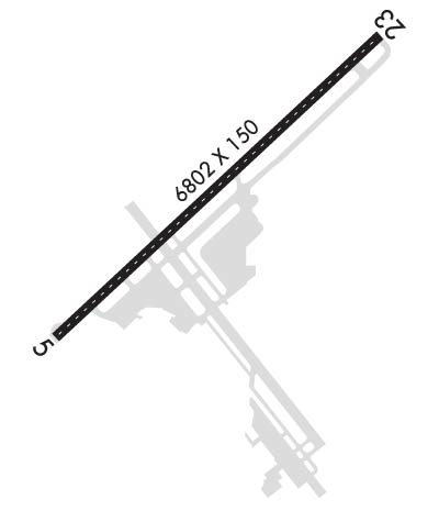
RWY 23 ENGINEERED MATERIALS ARRESTING SYSTEM (EMAS) 328 FT IN LENGTH BY 170 FT IN WIDTH LCTD AT THE DER.
ANG: AFLD MGMT OPS OPR 1200-2100Z++ MON-FRI, AND UNIT TRNG ASSEMBLY (UTA) WKND. PPR REQ FOR ALL ACFT 48 HR PRIOR FOR SVCG AND USE OF PARK RAMPS. FILE PPR NR IN
FUEL SERVICE-CAPITAL JET CENTER CTC 304-346--9977.
SERVICE-FUEL: A++(MIL).
RWY 05/2 3 PCR VALUE: 950/F/D/X/T
Airport Communications & Frequencies:
ATIS Frequencies:   Hours(local) of Operation: CONTINUOUS
127.6
CHARLESTON Tower Frequencies:   Hours(local) of operation: CONTINUOUS   
125.7
257.8
CHARLESTON Ground Frequencies:
121.8
348.6
Clearance Delivery Frequencies:
118.55
Emergency Frequencies:
121.5
243.0
Unicom Frequency:
122.950
CHARLESTON Primary Approach Frequencies:   Hours(local) of operation: CONTINUOUS   
119.2 ;SOUTH
124.1 ;NORTH
269.125
Part-time Approach Frequencies:  
128.5
CHARLESTON Primary Departure Frequencies:   Hours(local) of operation: CONTINUOUS   
119.2 ;SOUTH
124.1 ;NORTH
269.125
Part-time Departure Frequencies:  
128.5
Class C Frequencies:
119.2 ;SOUTH
124.1 ;NORTH
269.125
Runway Identifications
Runway Identification: 05/23
Length: 6715 ft
Width: 150 ft
Surface: ASPHALT-GOOD CONDITION
Edge lights: High Intensity

Treatment: GROOVED

 Runway: 05   Runway: 23
Mag heading: 53°Mag heading: 233°
Rwy Slope: -.78% DownRwy Slope: .78% Up
Approach: ILS/DMEApproach: ILS/DME
Pattern: Left TrafficPattern: Left Traffic
Markings: PRECISION INSTRUMENTMarkings: NONSTANDARD
Marking Condition: GOODMarking Condition: GOOD; RWY 23 MIL ASSAULT LDG ZONE AND PRECISION INSTR MARKINGS.
Arresting Dev: Arresting Dev: EMAS; ENGINEERED MATERIAL ARRESTING SYSTEM (EMAS) 328 FT IN LENGTH BY 170 FT IN WIDTH LCTD AT THE DER 23.
Lat & Long: N3822.2  W08136.1Lat. & Long.: N3822.9  W08135.1
Elev: 946.6 ft. MSLElev: 894.1 ft. MSL
TCH: 56 ft. AGLTCH: 56 ft. AGL
Visual Glide Path: 3.00 degreesVisual Glide Path: 3.00 degrees
Displaced Threshold: NoDisplaced Threshold: 500 feet
Touchdown Zone: YESTouchdown Zone: YES
Touchdown Elev.: 947.1 feetTouchdown Elev.: 931.2 feet
Visual Glide Slope: 4-Light PAPI on LEFT side of RunwayVisual Glide Slope: 4-BOX VASI ON RIGHT SIDE OF RUNWAY
RVR Equipment: TOUCHDOWN-ROLLOUTRVR Equipment: TOUCHDOWN-ROLLOUT
RVV Equipment: NORVV Equipment: NO
Approach Lights: Approach Lights: ALSF1 - standard 2,400 foot high intensity approach lighting system with sequenced flashers, Category I
REIL: YESREIL: NO
Centerline Lights: YESCenterline Lights: YES
Touchdown lights: NOTouchdown lights: NO
Runway Category: Precision Instrument RunwayRunway Category: Precision Instrument Runway
Declared Distances: TORA:6715' TODA:6715' ASDA:6215' LDA:6215'Declared Distances: TORA:6715' TODA:6715' ASDA:6715' LDA:6215'
Obstructions: POLEObstructions: POLE
Marked: LIGHTEDMarked: LIGHTED
Clearance slope: 16:1Clearance slope: 30:1
Obstruction height: 223 feet AGLObstruction height: 136 feet AGL
Dist. from runway: 3950 feetDist. from runway: 4300 feet
Centerline offset: 950 right of centerlineCenterline offset: 100 feet left of centerline
Comments: Comments:
C:44/P: