Outstanding service for corporate and general aviation owners and pilots

KCRG

JACKSONVILLE EXEC. AT CRAIG
JACKSONVILLE
FL
Time Zone: Eastern
Lat: N 3020.2
Long: W 08130.9
Elev: 41
Var: +06
Longest Runway: 4008
Clr Del: 118.35
Dept. ATIS: 125.4
Arr. ATIS: 125.4
AWOS: 119.62
Ground: 121.8
Tower: 132.1

FBO & Flight Services info for KCRG

FBOs: Update your Fuel Prices

  click here  
Full service FBO Offering the best service and competitive pricing.
-Valet car service to/from your aircraft
-MILITARY JET FUEL with use of 4100sqft Hangar/Office Space Included.
-24/7 Full & Self Service Fuel
-Transient Hangar Space
-MILITARY VETERAN OWNED and OPERATED
-Rental Car Valet to your Aircraft
-After Hours Service Available
Ph: 904-420-2000 Fax: 904-338-9541 Freq: 130.57WebsiteE-Mail
                     
Service
Jet
100LL
SAF
MoGas
Fuel Avail: 0600-2200 7-days, after hours available
Full4.987.49    Last Update: 04/23/2024 15:41
PRICES GUARANTEED by FBO.
Self  6.74    
Misc. Info: JAX Executive Jet Center is a full service FBO with the best fuel prices, customer service, and locaAddress: 985 CHARLES LINDBERG DRIVE   JACKSONVILLE, FL 32225

  click here  
Thank you for choosing Sky Harbor! On your next visit to Jacksonville take advantage of our Concierge services for trip planning, Courtesy Crew cars & renovated, comfortable facility. Hangar & tie down. Contract fuel, volume discounts. 24 hr Avgas Self Serve pump (taxi Alpha 4 or Alpha 5).
Ph: 877-641-8555 Fax: 904-641-9918 Freq: 129.25WebsiteE-Mail
                          
Service
Jet
100LL
SAF
MoGas
Fuel Avail: PRIST+$0.06/gal 0600-2200 daily , call 904 999 8634 for after hour service
Full5.097.82    Last Update: 04/18/2024 09:15
PRICES GUARANTEED by FBO. *
*INSTANT CASH REWARDS ON FUEL PURCHASES *
Self  6.86    
Misc. Info: Will match all contract fuel pricesAddress: 855-5 ST. JOHNS BLUFF ROAD   JACKSONVILLE, FL 32225

  click here  
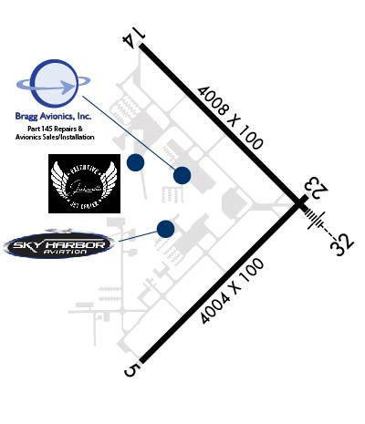
Bragg Avionics is a family owned avionics installation and repair facility located on Craig Airport in Jacksonville, FL. The Bragg family has been in avionics since the 1950s and has combined experience of over 100 years. We service a range of aircraft, from Cessna to King Air, pressurized and non-pressurized, light sport, experimental and helicopters.
Ph: 904-564-1717 Fax: 904-564-1718
-
WebsiteE-Mail
                                   
Service
Jet
100LL
SAF
MoGas
Fuel Avail: ~~NO FUEL
Full        Last Update: 04/26/2024 00:15:41

Self        
Misc. Info: FAA Repair Station UV1R546KAddress: 822 BRAGG AVENUE,   JACKSONVILLE, FL 32225

ASOSPh: 904-646-4670
-
-
 
If you are an FBO, call 1-203-262-1700 to update your info or email: FltPlan.Advertising@garmin.com
Advertise your FBO on FltPlan.com

Runway & Approach Info for KCRG
Rwy
Length
Land Dist**
Approach*
  Rwy
Length
Land Dist**
Approach*
05
4004x100  4004'          
 
  
23
  4004x100  4004'          
 
14
4008x100  4008'          
 
  
32
  4008x100  4008'          
ILS
 111.70 - 321°  
 * only ILS, LOC, LDA, and SDF approaches to a specific runway are shown
** For any Declared Landing Distance Available, please see A/FD or Approach plates
Runway Weight Capability (lbs.) Help
Runway IDSingle WheelDouble WheelDouble Tandem WheelDual Double Wheel
05/2330,000N/AN/AN/A
14/3230,000N/AN/AN/A
These numbers are Advisory and are not limits.   The Airport Manager should have more accurate Weight Limits
Approach Charts
Approaches    
Current Weather/Notams
Customs Information Send updates to Support@FltPlan.com
Customs Not Available
Database effective 05/16/2024
Airport Diagram of KCRG
Airport Diagram might not be current.

Facility Name: JACKSONVILLE EXEC AT CRAIG
City Name: JACKSONVILLE
County: DUVAL
State abbrev: FL
State Name: FLORIDA
   
Ownership: PUBLICLY OWNED
Use: OPEN TO THE PUBLIC
Owner's Name: JACKSONVILLE AVIATION AUTHORITY
Address: 14201 PECAN PARK ROAD
 JACKSONVILLE, FL 32218
Owner's Phone: 904-573-1613
  
Manager's Name: ROLF RIECHMANN
Address: 855-1 SAINT JOHNS BLUFF RD NORTH, SUITE 500
 JACKSONVILLE, FL 32225-8388
Phone: 904-741-5066; NOISE ABATEMENT COMPLAINTS 904-641-3606.
   
FAA Region: SOUTHERN
FAA Field Office: ORL


Sunrise / Sunset times for JACKSONVILLE EXEC AT CRAIG

DateSunriseSunset
04/25/24 Thursday6:4820:01
04/26/24 Friday6:4720:01
04/27/24 Saturday6:4620:02
04/28/24 Sunday6:4520:03
04/29/24 Monday6:4420:03
04/30/24 Tuesday6:4320:04
05/01/24 Wednesday6:4220:04
05/02/24 Thursday6:4120:05
05/03/24 Friday6:4020:06
05/04/24 Saturday6:3920:06
05/05/24 Sunday6:3920:07
05/06/24 Monday6:3820:08
05/07/24 Tuesday6:3720:08
05/08/24 Wednesday6:3620:09

Airport Facilities

Airport Attendance ScheduleMON-FRI 0600-2300, SAT-SUN 0700-2200
Airport Status OPERATIONAL (This Status can change at any time - please check NOTAMS)
Airport Lighting ScheduleWHEN ATCT CLSD ACTVT MALSR RWY 32; REIL RWY 14 & 23; HIRL RWY 14/32, MIRL RWY 5/23 - CTAF.
Airport Storage AvailableTie Downs, Hanger
Extra Services AvailableAir Ambulance, Avionics, Charter, Flight Instruction, Aircraft Rental, Aircraft Sales, Annual Surveying
Wind IndicatorYES - (lighted)
Control TowerYES
CTAF Frequency132.100
Unicom Frequency122.950
Rotating Beacon ColorWG
Segmented CircleYES
Landing FeeNO

Airport Inspection Data

Airport InspectedSTATE - performed by STATE AERONAUTICAL PERSONNEL
Inspection Date02/07/2024

Airport Services

Type of Fuel AvailableGrade 100LL, JET A (freeze point -40C)
Airframe Repair ServiceMAJOR
Power Plant Repair ServiceMAJOR

Geographic Data

LatitudeN3020.2
LongitudeW08130.9 (ESTIMATED)
Arpt Elevation40ft (SURVEYED)
Magnetic Variation06W
8 miles Eof JACKSONVILLE
Traffic Pattern Altitude
Sectional ChartJACKSONVILLE

Aircraft Data

Operations (Reported)YearlyAvg. Daily
General Aviation Transient 79920219
General Aviation Local 56209154
Air Taxi 760121
Commerical 00
Commuter 00
Military 1503941
Aircraft based on Field
General Aviation Singles 175
General Aviation Multi 41
Jet Aircraft 12
General Aviation Helicopters 8
Military Aircraft 18
Gliders 0
Ultralights 0

FAA Services

FSS on field NO
FSS tie-in GAINESVILLE
FSS Phone 1-800-WX-BRIEF
Who issues Notams CRG
Notam D service at airport YES
ARTCC Name JACKSONVILLE

Federal Status

Airport Certification
Aircraft Rescue & Firefighting IndexNone
Airport of EntryNo
Custom Landing RightsNo
Joint Civil/MilitaryNo
Military Landing rightsYES

Federal Agreements

NATIONAL PLAN OF INTEGRATED AIRPORT SYSTEMS (NPIAS)
GRANT AGREEMENTS UNDER FAAP/ADAP/AIP
SURPLUS PROPERTY AGREEMENT UNDER REGULATION 16-WAA
ASSURANCES PURSUANT TO TITLE VI, CIVIL RIGHTS ACT OF 1964
AGREEMENT UNDER DLAND OR DCLA HAS EXPIRED.

Remarks

BIRDS PERIODICALLY ON OR NEAR THE ARPT INCREASING IN ACTIVITY DURING INCLEMENT WEATHER.
BANNER TOWING ON WEEKENDS & SPECIAL EVENTS.
VFR NOISE ABATEMENT PROCEDURES IN EFFECT, CALL AMGR 904-641-7666. WX PERMITTING, RY 05 PREFERRED FOR APCH, RY 32 PREFERRED FOR DEP.
WILDLIFE ON & INVOF ARPT.
PAVEMENT ACCOMMODATES DESIGN GROUP II ACFT (UP TO 79 FT WINGSPAN) UP TO 60,000 LBS DUAL WHEEL LOADING. PPR FOR ACFT EXCEEDING THESE LTDS CTC AT 904-741-2020.
RWY 05/2 3 RY 05/23 HAS 75 FT STWYS BOTH ENDS.
RWY 14/3 2 RY 14/32 HAS 75 FT STWYS BOTH ENDS.
Airport Communications & Frequencies:
ATIS Frequencies:   Hours(local) of Operation: CONTINUOUS
125.4
CRAIG Tower Frequencies:   Hours(local) of operation: 0600-2300 MON-FRI; 0700-2200 SAT-SUN   
132.1
269.525
CRAIG Ground Frequencies:
121.8
Clearance Delivery Frequencies:
118.35
CTAF Frequency:
132.100
Unicom Frequency:
122.950
JACKSONVILLE Primary Approach Frequencies:  
124.9
308.4
JACKSONVILLE Primary Departure Frequencies:  
124.9
132.775 251-069
284.6 251-069
308.4 070-250
Runway Identifications
Runway Identification: 05/23
Length: 4004 ft
Width: 100 ft
Surface: ASPHALT-FAIR CONDITION
Edge lights: Medium Intensity

Treatment: NONE
Weight: PCN 31 /F/A/W/T

 Runway: 05   Runway: 23
Mag heading: 51°Mag heading: 231°
Rwy Slope: .00% UpRwy Slope: .00% Down
Approach: Approach:
Pattern: Left TrafficPattern: Left Traffic
Markings: NONPRECISION INSTRUMENTMarkings: NONPRECISION INSTRUMENT
Marking Condition: GOODMarking Condition: GOOD
Arresting Dev: Arresting Dev:
Lat & Long: N3019.7  W08131.1Lat. & Long.: N3020.2  W08130.6
Elev: 40.1 ft. MSLElev: 40.3 ft. MSL
TCH: 47 ft. AGLTCH: 52 ft. AGL
Visual Glide Path: 3.00 degreesVisual Glide Path: 3.00 degrees
Displaced Threshold: NoDisplaced Threshold: No
Touchdown Zone: YESTouchdown Zone: YES
Touchdown Elev.: 40.5 feetTouchdown Elev.: 40.5 feet
Visual Glide Slope: 4-Light PAPI on LEFT side of Runway; UNUSBL BYD 3.5 MILES ON FINAL DUE TO LRG TWRS LCTD ON EXTDD CNTRLN.Visual Glide Slope: 4-Light PAPI on LEFT side of Runway; UNUSBL BYD 8.0 DEGS LEFT AND RIGHT OF CNTRLN.
RVR Equipment: RVR Equipment:
RVV Equipment: NORVV Equipment: NO
Approach Lights: Approach Lights:
REIL: NOREIL: YES
Centerline Lights: NOCenterline Lights: NO
Touchdown lights: NOTouchdown lights: NO
Runway Category: Runway with a Visual ApproachRunway Category: Runway with a Visual Approach
Declared Distances: Declared Distances:
Obstructions: TOWERObstructions: TREES
Marked: MARKED and LIGHTEDMarked: NOT Marked/Lighted
Clearance slope: 25:1Clearance slope: 21:1
Obstruction height: 114 feet AGLObstruction height: 36 feet AGL
Dist. from runway: 3030 feetDist. from runway: 975 feet
Centerline offset: 250 right of centerlineCenterline offset: 240 feet left of centerline
Comments: Comments:
Runway Identification: 14/32
Length: 4008 ft
Width: 100 ft
Surface: ASPHALT-GOOD CONDITION
Edge lights: High Intensity

Treatment: NONE
Weight: PCN 34 /F/A/W/T

 Runway: 14   Runway: 32
Mag heading: 141°Mag heading: 321°
Rwy Slope: .21% UpRwy Slope: -.21% Down
Approach: Approach: ILS
Pattern: Left TrafficPattern: Left Traffic
Markings: NONPRECISION INSTRUMENTMarkings: PRECISION INSTRUMENT
Marking Condition: FAIRMarking Condition: FAIR
Arresting Dev: Arresting Dev:
Lat & Long: N3020.6  W08131.1Lat. & Long.: N3020.2  W08130.6
Elev: 32.0 ft. MSLElev: 40.3 ft. MSL
TCH: 44 ft. AGLTCH: 43 ft. AGL
Visual Glide Path: 3.00 degreesVisual Glide Path: 3.00 degrees
Displaced Threshold: NoDisplaced Threshold: No
Touchdown Zone: YESTouchdown Zone: YES
Touchdown Elev.: 40.7 feetTouchdown Elev.: 40.7 feet
Visual Glide Slope: 4-Light PAPI on LEFT side of RunwayVisual Glide Slope: 4-Light PAPI on LEFT side of Runway
RVR Equipment: RVR Equipment:
RVV Equipment: NORVV Equipment: NO
Approach Lights: Approach Lights: MALSR - 1,400 foot medium intensity approach lighting system with runway alignment indicator lights
REIL: YESREIL: NO
Centerline Lights: NOCenterline Lights: NO
Touchdown lights: NOTouchdown lights: NO
Runway Category: Runway with a Non-precision Approach having visibility minimums greater than 3/4 mileRunway Category: Precision Instrument Runway
Declared Distances: Declared Distances:
Obstructions: TREESObstructions: BRUSH
Marked: NOT Marked/LightedMarked: NOT Marked/Lighted
Clearance slope: 37:1Clearance slope: 50:1
Obstruction height: 61 feet AGLObstruction height: 20 feet AGL
Dist. from runway: 2465 feetDist. from runway: 1200 feet
Centerline offset: 290 left of centerlineCenterline offset: 220 feet right of centerline
Comments: Comments:
C:124/P: