
| ||||||||||||||||||||||||||||||||||||||||||||
| ||||||||||||||||||||||||||||||||||||||||||||
| ||||||||||||||||||||||||||||||||||||||||||||
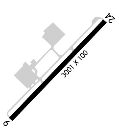
| Rwy | Rwy | |||||||
| 3001x100 | 3001' | 3001x100 | 3001' | |||||
| Runway ID | Single Wheel | Double Wheel | Double Tandem Wheel | Dual Double Wheel |
| 06/24 | 30,000 | N/A | N/A | N/A |
| These numbers are Advisory and are not limits. The Airport Manager should have more accurate Weight Limits | ||||
 Airport Diagram might not be current. | |
| Facility Name: | CHATHAM MUNI |
| City Name: | CHATHAM |
| County: | BARNSTABLE |
| State abbrev: | MA |
| State Name: | MASSACHUSETTS |
| Ownership: | PUBLICLY OWNED |
| Use: | OPEN TO THE PUBLIC |
| Owner's Name: | TOWN OF CHATHAM |
| Address: | 549 MAIN STREET |
| CHATHAM, MA 02633 | |
| Owner's Phone: | 508-945-5100 |
| Manager's Name: | TIMOTHY HOWARD |
| Address: | CHATHAM MUNICIPAL AIRPORT, GEORGE RYDER ROAD |
| CHATHAM, MA 02633 | |
| Phone: | 508-945-9000 |
| FAA Region: | NEW ENGLAND |
| FAA Field Office: | NONE |
| Date | Sunrise | Sunset |
|---|---|---|
| 04/24/24 Wednesday | 5:45 | 19:31 |
| 04/25/24 Thursday | 5:44 | 19:32 |
| 04/26/24 Friday | 5:42 | 19:34 |
| 04/27/24 Saturday | 5:41 | 19:35 |
| 04/28/24 Sunday | 5:40 | 19:36 |
| 04/29/24 Monday | 5:38 | 19:37 |
| 04/30/24 Tuesday | 5:37 | 19:38 |
| 05/01/24 Wednesday | 5:36 | 19:39 |
| 05/02/24 Thursday | 5:34 | 19:40 |
| 05/03/24 Friday | 5:33 | 19:41 |
| 05/04/24 Saturday | 5:32 | 19:42 |
| 05/05/24 Sunday | 5:31 | 19:43 |
| 05/06/24 Monday | 5:29 | 19:44 |
| 05/07/24 Tuesday | 5:28 | 19:45 |
| Airport Attendance Schedule | 7 Days A Week 0800-DUSK |
| Airport Status | OPERATIONAL (This Status can change at any time - please check NOTAMS) |
| Airport Lighting Schedule | ACTVT MIRL RWY 06/24 - 122.95. |
| Airport Storage Available | Tie Downs, Hanger |
| Extra Services Available | Flight Instruction, Aircraft Rental |
| Wind Indicator | YES - (unlit) |
| Control Tower | NO |
| CTAF Frequency | 122.800 |
| Unicom Frequency | 122.800 |
| Rotating Beacon Color | WG |
| Segmented Circle | YES |
| Landing Fee | NO |
| Airport Inspected | STATE - performed by STATE AERONAUTICAL PERSONNEL |
| Inspection Date | 06/01/2023 |
| Type of Fuel Available | Grade 100LL, JET A (freeze point -40C), JET A |
| Airframe Repair Service | MAJOR |
| Power Plant Repair Service | MINOR |
| Latitude | N4141.3 |
| Longitude | W06959.4 (ESTIMATED) |
| Arpt Elevation | 63ft (SURVEYED) |
| Magnetic Variation | 16W |
| 2 miles NW | of CHATHAM |
| Traffic Pattern Altitude | |
| Sectional Chart | NEW YORK |
| Operations (Reported) | Yearly | Avg. Daily |
|---|---|---|
| General Aviation Transient | 7300 | 20 |
| General Aviation Local | 14000 | 38 |
| Air Taxi | 700 | 2 |
| Commerical | 0 | 0 |
| Commuter | 0 | 0 |
| Military | 100 | 0 |
| Aircraft based on Field | |
|---|---|
| General Aviation Singles | 32 |
| General Aviation Multi | 2 |
| Jet Aircraft | 0 |
| General Aviation Helicopters | 5 |
| Military Aircraft | 0 |
| Gliders | 0 |
| Ultralights | 0 |
| FSS on field | NO |
| FSS tie-in | BRIDGEPORT |
| FSS Phone | 1-800-WX-BRIEF |
| Who issues Notams | CQX |
| Notam D service at airport | YES |
| ARTCC Name | BOSTON |
| Airport Certification | |
| Aircraft Rescue & Firefighting Index | None |
| Airport of Entry | No |
| Custom Landing Rights | No |
| Joint Civil/Military | No |
| Military Landing rights | YES |
| NATIONAL PLAN OF INTEGRATED AIRPORT SYSTEMS (NPIAS) |
| GRANT AGREEMENTS UNDER FAAP/ADAP/AIP |
| ASSURANCES PURSUANT TO TITLE VI, CIVIL RIGHTS ACT OF 1964 |
| BE AWARE OF HIGH-SPD MIL JET & HVY HEL TFC VCNTY CAPE COD CGAS. |
| BIRDS PRIMLY GULLS AND WILDLIFE ON OR INVOF ARPT. |
| RCMD MIN ALT OF 2000 FT AGL FM NORTHEAST TO SOUTHEAST OF ARPT OVER NATL SEASHORE . |
| WATER LDG AREA CLSD PERMLY. |
| NOISE ABATEMENT RWY 6/24. USE FULL RWY & AVOID INTXN DEPS. MINIMIZE /AVOID TGL OPNS. CLIMB OUT ON RWY HDG TIL 1000 FT OVR WATER THEN PROCD ON CRS. REDUCE PWR AS SOON AS PRACTICAL. |
| RWY 6/24, FLY PAT DOWNWIND LEG 1/2 TO 1 MILE OUT FM RWY AS PRACTICABLE. |
| AVOID RESIDENTIAL AREAS AS MUCH AS PSBL. |
| FOR CD CTC BOSTON APCH AT 603-594-5554. |
Airport Communications & Frequencies:
| |||||||||||||||
| Runway: 06 | Runway: 24 | ||
| Mag heading: | 60° | Mag heading: | 240° |
| Rwy Slope: | .45% Up | Rwy Slope: | -.45% Down |
| Approach: | Approach: | ||
| Pattern: | Left Traffic | Pattern: | Left Traffic |
| Markings: | BASIC | Markings: | BASIC |
| Marking Condition: | GOOD | Marking Condition: | GOOD |
| Arresting Dev: | Arresting Dev: | ||
| Lat & Long: | N4141.1 W06959.6 | Lat. & Long.: | N4141.5 W06959.2 |
| Elev: | 49.0 ft. MSL | Elev: | 62.6 ft. MSL |
| TCH: | 39 ft. AGL | TCH: | 39 ft. AGL |
| Visual Glide Path: | 3.50 degrees | Visual Glide Path: | 3.50 degrees |
| Displaced Threshold: | No | Displaced Threshold: | No |
| Touchdown Zone: | YES | Touchdown Zone: | YES |
| Touchdown Elev.: | 63.6 feet | Touchdown Elev.: | 63.6 feet |
| Visual Glide Slope: | 2-Light PAPI on LEFT side of Runway | Visual Glide Slope: | 2-Light PAPI on RIGHT side of Runway |
| RVR Equipment: | RVR Equipment: | ||
| RVV Equipment: | NO | RVV Equipment: | NO |
| Approach Lights: | Approach Lights: | ||
| REIL: | YES | REIL: | YES |
| Centerline Lights: | NO | Centerline Lights: | NO |
| Touchdown lights: | NO | Touchdown lights: | NO |
| Runway Category: | Runway with a Non-precision Approach | Runway Category: | Runway with a Non-precision Approach |
| Declared Distances: | Declared Distances: | ||
| Obstructions: | TREES | Obstructions: | TANK |
| Marked: | NOT Marked/Lighted | Marked: | NOT Marked/Lighted |
| Clearance slope: | 5:1 | Clearance slope: | 12:1 |
| Obstruction height: | 120 feet AGL | Obstruction height: | 232 feet AGL |
| Dist. from runway: | 800 feet | Dist. from runway: | 3100 feet |
| Centerline offset: | 150 right of centerline | Centerline offset: | 25 feet left of centerline |
| Comments: | Comments: |
