Click here for more info on on SMS!

KCQM

COOK MUNI
COOK
MN
Time Zone: Central
Lat: N 4749.3
Long: W 09241.4
Elev: 1329
Var: -01
Longest Runway: 4000
AWOS: 118.17
CTAF: 122.9

FBO & Flight Services info for KCQM

FBOs: Update your Fuel Prices

COOK MUN ARPTPh: 218-666-9931
-
Freq: 122.9

AWOSPh: 218-666-2539
-
Freq: 118.17  
If you are an FBO, call 1-203-262-1700 to update your info or email: FltPlan.Advertising@garmin.com
Advertise your FBO on FltPlan.com

Runway & Approach Info for KCQM
Rwy
Length
Land Dist**
Approach*
  Rwy
Length
Land Dist**
Approach*
13
4000x75  4000'          
 
  
31
  4000x75  4000'          
 
 * only ILS, LOC, LDA, and SDF approaches to a specific runway are shown
** For any Declared Landing Distance Available, please see A/FD or Approach plates
Runway Weight Capability (lbs.) Help
Runway IDSingle WheelDouble WheelDouble Tandem WheelDual Double Wheel
13/31N/AN/AN/AN/A
These numbers are Advisory and are not limits.   The Airport Manager should have more accurate Weight Limits
Approach Charts
Approaches    
Current Weather/Notams
Customs Information Send updates to Support@FltPlan.com
Customs Not Available
Database effective 05/16/2024
Airport Diagram of KCQM
Airport Diagram might not be current.

Facility Name: COOK MUNI
City Name: COOK
County: ST LOUIS
State abbrev: MN
State Name: MINNESOTA
   
Ownership: PUBLICLY OWNED
Use: OPEN TO THE PUBLIC
Owner's Name: CITY OF COOK
Address: BOX 155
 COOK, MN 55723
Owner's Phone: 218-666-2200
  
Manager's Name: DOUGLAS MCDUFF
Address: 9393 AIRPORT ROAD, PO BOX 155, CITY HALL
 COOK, MN 55723
Phone: (218) 666-9931
   
FAA Region: GREAT LAKES
FAA Field Office: DMA


Sunrise / Sunset times for COOK MUNI

DateSunriseSunset
04/22/24 Monday6:0720:12
04/23/24 Tuesday6:0520:13
04/24/24 Wednesday6:0420:15
04/25/24 Thursday6:0220:16
04/26/24 Friday6:0020:18
04/27/24 Saturday5:5820:19
04/28/24 Sunday5:5720:20
04/29/24 Monday5:5520:22
04/30/24 Tuesday5:5320:23
05/01/24 Wednesday5:5220:25
05/02/24 Thursday5:5020:26
05/03/24 Friday5:4920:27
05/04/24 Saturday5:4720:29
05/05/24 Sunday5:4520:30

Airport Facilities

Airport Attendance Schedule7 Days A Week 0900-1300
Airport Status OPERATIONAL (This Status can change at any time - please check NOTAMS)
Airport Lighting ScheduleACTVT REIL RWY 13 & 31; PAPI RWY 13 & 31; MIRL RWY 13/31 - CTAF. MIRL RWY 13/31 PRESET LOW SS-SR; INCR INTST - CTAF.
Airport Storage AvailableTie Downs
Extra Services AvailableNONE
Wind IndicatorYES - (lighted)
Control TowerNO
CTAF Frequency122.900
Unicom Frequency
Rotating Beacon ColorWG
Segmented CircleNO
Landing FeeNO

Airport Inspection Data

Airport InspectedSTATE - performed by STATE AERONAUTICAL PERSONNEL
Inspection Date07/05/2023

Airport Services

Type of Fuel AvailableGrade 100LL, JET A (freeze point -40C); -10SELF SERVICE FUEL AVBL H24.
Airframe Repair ServiceNone
Power Plant Repair ServiceNone

Geographic Data

LatitudeN4749.3
LongitudeW09241.4 (ESTIMATED)
Arpt Elevation1328ft (SURVEYED)
Magnetic Variation01E
2 miles Sof COOK
Traffic Pattern Altitude
Sectional ChartGREEN BAY

Aircraft Data

Operations (Reported)YearlyAvg. Daily
General Aviation Transient 17505
General Aviation Local 420012
Air Taxi 00
Commerical 00
Commuter 00
Military 00
Aircraft based on Field
General Aviation Singles 21
General Aviation Multi 0
Jet Aircraft 0
General Aviation Helicopters 0
Military Aircraft 0
Gliders 0
Ultralights 2

FAA Services

FSS on field NO
FSS tie-in PRINCETON
FSS Phone 1-800-WX-BRIEF
Who issues Notams CQM
Notam D service at airport YES
ARTCC Name MINNEAPOLIS

Federal Status

Airport Certification
Aircraft Rescue & Firefighting IndexNone
Airport of EntryNo
Custom Landing RightsNo
Joint Civil/MilitaryNo
Military Landing rightsNo

Federal Agreements

NATIONAL PLAN OF INTEGRATED AIRPORT SYSTEMS (NPIAS)

Remarks

FOR CD CTC MINNEAPOLIS ARTCC AT 651-463-5588.
AFT HRS CTC AMGR 808-855-5520.
Airport Communications & Frequencies:
CTAF Frequency:
122.900
Remarks
  • COMMUNICATIONS PRVDD BY PRINCETON RADIO ON FREQ 122.2 (EVELETH RCO).
  • APCH/DEP SVC PRVDD BY MINNEAPOLIS ARTCC (ZMP) ON FREQ 127.9/281.45 (DULUTH RCAG).
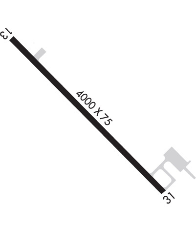
  • Runway Identifications
    Runway Identification: 13/31
    Length: 4000 ft
    Width: 75 ft
    Surface: ASPHALT-GOOD CONDITION
    Edge lights: Medium Intensity

    Treatment: NONE

     Runway: 13   Runway: 31
    Mag heading: 135°Mag heading: 315°
    Rwy Slope: -.25% DownRwy Slope: .25% Up
    Approach: Approach:
    Pattern: Left TrafficPattern: Left Traffic
    Markings: NONPRECISION INSTRUMENTMarkings: NONPRECISION INSTRUMENT
    Marking Condition: GOODMarking Condition: GOOD
    Arresting Dev: Arresting Dev:
    Lat & Long: N4749.6  W09241.7Lat. & Long.: N4749.1  W09241.0
    Elev: 1327.4 ft. MSLElev: 1317.4 ft. MSL
    TCH: 43 ft. AGLTCH: 47 ft. AGL
    Visual Glide Path: 3.00 degreesVisual Glide Path: 3.00 degrees
    Displaced Threshold: NoDisplaced Threshold: No
    Touchdown Zone: YESTouchdown Zone: YES
    Touchdown Elev.: 1328.9 feetTouchdown Elev.: 1327.8 feet
    Visual Glide Slope: 4-Light PAPI on LEFT side of RunwayVisual Glide Slope: 4-Light PAPI on LEFT side of Runway
    RVR Equipment: RVR Equipment:
    RVV Equipment: NORVV Equipment: NO
    Approach Lights: Approach Lights:
    REIL: YESREIL: YES
    Centerline Lights: NOCenterline Lights: NO
    Touchdown lights: NOTouchdown lights: NO
    Runway Category: Runway with a Non-precision ApproachRunway Category: Runway with a Non-precision Approach
    Declared Distances: Declared Distances:
    Obstructions: UnknownObstructions: TREE
    Marked: NOT Marked/LightedMarked: NOT Marked/Lighted
    Clearance slope: 14:1Clearance slope: 18:1
    Obstruction height: 14 feet AGLObstruction height: 42 feet AGL
    Dist. from runway: 408 feetDist. from runway: 957 feet
    Centerline offset: 271Centerline offset: 65 feet left of centerline
    Comments: Comments:
    C:2/P: