Current Weather/Notams (Metars, TAFs, Notams, NWS Forecast, PIREPS, and nearby weather)
Customs Information Send updates to Support@FltPlan.com
Customs Not Available
Database effective 05/16/2024
Airport Diagram might not be current.
|
| Facility Name: | ST LOUIS DOWNTOWN |
| City Name: | CAHOKIA/ST LOUIS |
| County: | ST CLAIR |
| State abbrev: | IL |
| State Name: | ILLINOIS |
| | |
| Ownership: | PUBLICLY OWNED |
| Use: | OPEN TO THE PUBLIC |
| Owner's Name: | BI-STATE DEVELOPMENT AGENCY |
| Address: | 6100 ARCHVIEW DRIVE |
| | CAHOKIA, IL 62206-1445 |
| Owner's Phone: | 618-337-6060 |
| | |
| Manager's Name: | SANDRA SHORE |
| Address: | 6100 ARCHVIEW DRIVE |
| | CAHOKIA, IL 62206-1445 |
| Phone: | 618-337-6060 |
| | |
| FAA Region: | GREAT LAKES |
| FAA Field Office: | CHI |
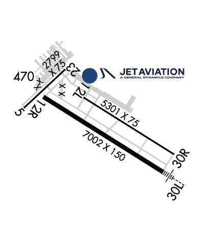
Runway Identifications
Runway Identification: 05/23Length: 2799 ft
Width: 75 ft
Surface: ASPHALT-FAIR CONDITION
Edge lights: Medium IntensityTreatment: NONE
Weight: PCN 11 /R/C/W/T
| | Runway: 05 | | Runway: 23 |
| Mag heading: | 47° | Mag heading: | 227° |
| Rwy Slope: | -.05% Down | Rwy Slope: | .05% Up |
| Approach: | | Approach: | |
| Pattern: | Left Traffic | Pattern: | Left Traffic |
| Markings: | BASIC | Markings: | BASIC |
| Marking Condition: | POOR; SFC MARKINGS FADED. | Marking Condition: | POOR; SFC MARKINGS FADED. |
| Arresting Dev: | | Arresting Dev: | |
| Lat & Long: | N3834.3 W09010.1 | Lat. & Long.: | N3834.7 W09009.7 |
| Elev: | 410.0 ft. MSL | Elev: | 408.6 ft. MSL |
| TCH: | | TCH: | |
| Visual Glide Path: | | Visual Glide Path: | |
| Displaced Threshold: | No | Displaced Threshold: | No |
| Touchdown Zone: | YES | Touchdown Zone: | YES |
| Touchdown Elev.: | 412.9 feet | Touchdown Elev.: | 412.9 feet |
| Visual Glide Slope: | | Visual Glide Slope: | |
| RVR Equipment: | | RVR Equipment: | |
| RVV Equipment: | NO | RVV Equipment: | NO |
| Approach Lights: | | Approach Lights: | |
| REIL: | NO | REIL: | NO |
| Centerline Lights: | NO | Centerline Lights: | NO |
| Touchdown lights: | NO | Touchdown lights: | NO |
| Runway Category: | Runway with a Visual Approach | Runway Category: | Runway with a Visual Approach |
| Declared Distances: | TORA:2799' TODA:2799' ASDA:2799' LDA:2799' | Declared Distances: | TORA:2799' TODA:2799' ASDA:2799' LDA:2799' |
| Obstructions: | TREE | Obstructions: | TOWER |
| Marked: | NOT Marked/Lighted | Marked: | LIGHTED |
| Clearance slope: | 11:1 | Clearance slope: | 20:1 |
| Obstruction height: | 58 feet AGL | Obstruction height: | 72 feet AGL |
| Dist. from runway: | 839 feet | Dist. from runway: | 1647 feet |
| Centerline offset: | 58 right of centerline | Centerline offset: | 16 feet right of centerline |
| Comments: | | Comments: | |
Runway Identification: 12L/30RLength: 5301 ft
Width: 75 ft
Surface: CONCRETE-FAIR CONDITION
Edge lights: Medium IntensityTreatment: NONE
Weight: PCN 10 /F/D/X/T
| | Runway: 12L | | Runway: 30R |
| Mag heading: | 122° | Mag heading: | 302° |
| Rwy Slope: | -.07% Down | Rwy Slope: | .07% Up |
| Approach: | | Approach: | |
| Pattern: | Left Traffic | Pattern: | Right Traffic |
| Markings: | NONPRECISION INSTRUMENT | Markings: | NONPRECISION INSTRUMENT |
| Marking Condition: | FAIR | Marking Condition: | FAIR |
| Arresting Dev: | | Arresting Dev: | |
| Lat & Long: | N3834.4 W09009.5 | Lat. & Long.: | N3834.0 W09008.6 |
| Elev: | 410.0 ft. MSL | Elev: | 406.5 ft. MSL |
| TCH: | | TCH: | |
| Visual Glide Path: | | Visual Glide Path: | |
| Displaced Threshold: | No | Displaced Threshold: | No |
| Touchdown Zone: | YES | Touchdown Zone: | YES |
| Touchdown Elev.: | 410.0 feet | Touchdown Elev.: | 407.9 feet |
| Visual Glide Slope: | | Visual Glide Slope: | |
| RVR Equipment: | | RVR Equipment: | |
| RVV Equipment: | NO | RVV Equipment: | NO |
| Approach Lights: | | Approach Lights: | |
| REIL: | YES | REIL: | YES |
| Centerline Lights: | NO | Centerline Lights: | NO |
| Touchdown lights: | NO | Touchdown lights: | NO |
| Runway Category: | Runway with a Visual Approach | Runway Category: | Runway with a Non-precision Approach having visibility minimums greater than 3/4 mile |
| Declared Distances: | TORA:5300' TODA:5300' ASDA:5300' LDA:5300' | Declared Distances: | TORA:5300' TODA:5300' ASDA:5300' LDA:5300' |
| Obstructions: | TREE | Obstructions: | TREE |
| Marked: | NOT Marked/Lighted | Marked: | NOT Marked/Lighted |
| Clearance slope: | 37:1 | Clearance slope: | 34:1 |
| Obstruction height: | 96 feet AGL | Obstruction height: | 72 feet AGL |
| Dist. from runway: | 3817 feet | Dist. from runway: | 2664 feet |
| Centerline offset: | 254 left of centerline | Centerline offset: | 306 feet right of centerline |
| Comments: | | Comments: | |
Runway Identification: 12R/30LLength: 7002 ft
Width: 150 ft
Surface: ASPHALT
Edge lights: High IntensityTreatment: GROOVED
Weight: PCN 48 /F/D/X/T
| | Runway: 12R | | Runway: 30L |
| Mag heading: | 122° | Mag heading: | 302° |
| Rwy Slope: | -.06% Down | Rwy Slope: | .06% Up |
| Approach: | | Approach: | ILS |
| Pattern: | Right Traffic | Pattern: | Left Traffic |
| Markings: | PRECISION INSTRUMENT | Markings: | PRECISION INSTRUMENT |
| Marking Condition: | GOOD | Marking Condition: | GOOD |
| Arresting Dev: | | Arresting Dev: | |
| Lat & Long: | N3834.4 W09009.9 | Lat. & Long.: | N3833.8 W09008.7 |
| Elev: | 412.4 ft. MSL | Elev: | 408.0 ft. MSL |
| TCH: | 49 ft. AGL | TCH: | 53 ft. AGL |
| Visual Glide Path: | 3.00 degrees | Visual Glide Path: | 3.00 degrees |
| Displaced Threshold: | No | Displaced Threshold: | No |
| Touchdown Zone: | YES | Touchdown Zone: | YES |
| Touchdown Elev.: | 412.4 feet | Touchdown Elev.: | 411.2 feet |
| Visual Glide Slope: | 4-Light PAPI on LEFT side of Runway | Visual Glide Slope: | 4-Light PAPI on LEFT side of Runway |
| RVR Equipment: | | RVR Equipment: | |
| RVV Equipment: | NO | RVV Equipment: | NO |
| Approach Lights: | | Approach Lights: | MALSR - 1,400 foot medium intensity approach lighting system with runway alignment indicator lights |
| REIL: | YES | REIL: | NO |
| Centerline Lights: | NO | Centerline Lights: | NO |
| Touchdown lights: | NO | Touchdown lights: | NO |
| Runway Category: | Runway with a Non-precision Approach having visibility minimums greater than 3/4 mile | Runway Category: | Precision Instrument Runway |
| Declared Distances: | TORA:7002' TODA:7002' ASDA:7002' LDA:7002' | Declared Distances: | TORA:7002' TODA:7002' ASDA:7002' LDA:7002' |
| Obstructions: | TREE | Obstructions: | POLE |
| Marked: | NOT Marked/Lighted | Marked: | NOT Marked/Lighted |
| Clearance slope: | 20:1 | Clearance slope: | 36:1 |
| Obstruction height: | 30 feet AGL | Obstruction height: | 29 feet AGL |
| Dist. from runway: | 809 feet | Dist. from runway: | 1688 feet |
| Centerline offset: | 487 left of centerline | Centerline offset: | 362 feet left of centerline |
| Comments: | | Comments: | |