Current Weather/Notams (Metars, TAFs, Notams, NWS Forecast, PIREPS, and nearby weather)
Customs Information Send updates to Support@FltPlan.com
Customs Not Available
Database effective 04/18/2024
Airport Diagram might not be current.
|
| Facility Name: | WENDELL H FORD |
| City Name: | HAZARD |
| County: | PERRY |
| State abbrev: | KY |
| State Name: | KENTUCKY |
| | |
| Ownership: | PUBLICLY OWNED |
| Use: | OPEN TO THE PUBLIC |
| Owner's Name: | HAZARD-PERRY COUNTY BOARD |
| Address: | P.O. BOX 2346 |
| | HAZARD, KY 41702 |
| Owner's Phone: | (606) 439-4518 |
| | |
| Manager's Name: | JEFF HYLTON |
| Address: | 1300 WENDELL H. FORD TERMINAL ROAD |
| | CHAVIES, KY 41727 |
| Phone: | (606) 233-5140 |
| | |
| FAA Region: | SOUTHERN |
| FAA Field Office: | MEM |
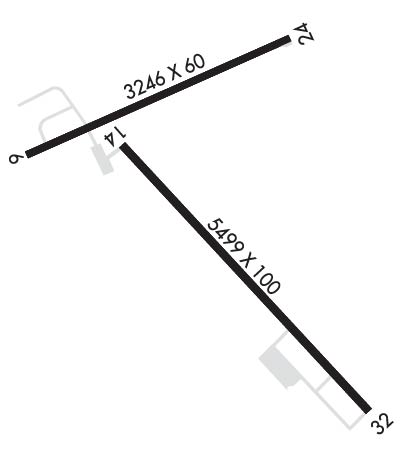
Runway Identifications
Runway Identification: 06/24Length: 3246 ft
Width: 60 ft
Surface: ASPHALT-GOOD CONDITION
Edge lights: Treatment: NONE
Weight: PCN 10 /F/C/X/T
| | Runway: 06 | | Runway: 24 |
| Mag heading: | 65° | Mag heading: | 245° |
| Rwy Slope: | .01% Up | Rwy Slope: | -.01% Down |
| Approach: | | Approach: | |
| Pattern: | Left Traffic | Pattern: | Left Traffic |
| Markings: | BASIC | Markings: | BASIC |
| Marking Condition: | GOOD | Marking Condition: | GOOD |
| Arresting Dev: | | Arresting Dev: | |
| Lat & Long: | N3723.4 W08316.2 | Lat. & Long.: | N3723.6 W08315.6 |
| Elev: | 1242.3 ft. MSL | Elev: | 1242.5 ft. MSL |
| TCH: | | TCH: | |
| Visual Glide Path: | | Visual Glide Path: | |
| Displaced Threshold: | 200 feet | Displaced Threshold: | 271 feet |
| Touchdown Zone: | YES | Touchdown Zone: | YES |
| Touchdown Elev.: | 1244.7 feet | Touchdown Elev.: | 1244.7 feet |
| Visual Glide Slope: | | Visual Glide Slope: | |
| RVR Equipment: | | RVR Equipment: | |
| RVV Equipment: | NO | RVV Equipment: | NO |
| Approach Lights: | | Approach Lights: | |
| REIL: | NO | REIL: | NO |
| Centerline Lights: | NO | Centerline Lights: | NO |
| Touchdown lights: | NO | Touchdown lights: | NO |
| Runway Category: | Runway with a Visual Approach | Runway Category: | Runway with a Visual Approach |
| Declared Distances: | | Declared Distances: | |
| Comments: | | Comments: | SMALL TREES AND BRUSH GROWING APPROX 25' FROM THE END OF PAVEMENT BOTH SIDE OF CENTERLINE |
Runway Identification: 14/32Length: 5499 ft
Width: 100 ft
Surface: ASPHALT-GOOD CONDITION
Edge lights: Medium IntensityTreatment: NONE
Weight: PCN 10 /F/C/X/T
| | Runway: 14 | | Runway: 32 |
| Mag heading: | 145° | Mag heading: | 325° |
| Rwy Slope: | .24% Up | Rwy Slope: | -.24% Down |
| Approach: | LOCALIZER | Approach: | |
| Pattern: | Left Traffic | Pattern: | Left Traffic |
| Markings: | NONPRECISION INSTRUMENT | Markings: | NONPRECISION INSTRUMENT |
| Marking Condition: | GOOD | Marking Condition: | GOOD |
| Arresting Dev: | | Arresting Dev: | |
| Lat & Long: | N3723.4 W08315.9 | Lat. & Long.: | N3722.7 W08315.2 |
| Elev: | 1243.0 ft. MSL | Elev: | 1256.4 ft. MSL |
| TCH: | 31 ft. AGL | TCH: | 38 ft. AGL |
| Visual Glide Path: | 3.00 degrees | Visual Glide Path: | 4.00 degrees |
| Displaced Threshold: | No | Displaced Threshold: | No |
| Touchdown Zone: | YES | Touchdown Zone: | YES |
| Touchdown Elev.: | 1243.0 feet | Touchdown Elev.: | 1256.4 feet |
| Visual Glide Slope: | 4-Light PAPI on LEFT side of Runway | Visual Glide Slope: | 4-Light PAPI on LEFT side of Runway; PAPIRWY 32 UNUSBL BYD 2.5 NM; PAPI RWY 32 UNUSBL BYD 7 DEGS RIGHT & BYD 5 DEGS LEFT OF CTNRLN. |
| RVR Equipment: | | RVR Equipment: | |
| RVV Equipment: | NO | RVV Equipment: | NO |
| Approach Lights: | | Approach Lights: | |
| REIL: | YES | REIL: | YES |
| Centerline Lights: | NO | Centerline Lights: | NO |
| Touchdown lights: | NO | Touchdown lights: | NO |
| Runway Category: | D | Runway Category: | Runway with a Non-precision Approach having visibility minimums greater than 3/4 mile |
| Declared Distances: | | Declared Distances: | |
| Obstructions: | HANGAR | Obstructions: | TREES |
| Marked: | NOT Marked/Lighted | Marked: | NOT Marked/Lighted |
| Clearance slope: | 27:1 | Clearance slope: | 18:1 |
| Obstruction height: | 16 feet AGL | Obstruction height: | 239 feet AGL |
| Dist. from runway: | 640 feet | Dist. from runway: | 4544 feet |
| Centerline offset: | 483 right of centerline | Centerline offset: | 755 feet left of centerline |
| Comments: | | Comments: | |

