Click here for more info on on SMS!

KCOU

COLUMBIA RGNL
COLUMBIA
MO
Time Zone: Central
Lat: N 3849.1
Long: W 09213.1
Elev: 889
Var: -00
Longest Runway: 7401
Dept. ATIS: 128.45
Arr. ATIS: 128.45
AWOS: 128.45
Ground: 121.6
Tower: 119.3

FBO & Flight Services info for KCOU

FBOs: Update your Fuel Prices
Providing high quality fuel and services to you and your customers, from Phillips 66 Aviation.
Ph: 573-443-1576 Fax: 573-443-7283 Freq: 122.95WebsiteE-Mail
                   
Service
Jet
100LL
SAF
MoGas
Fuel Avail: PRIST PREMIXED
Full5.956.90    Last Update: 04/26/2024 09:34

Self        
Misc. Info: Address: 11200 S AIRPORT DR   COLUMBIA, MO 65201

ASOSPh: 573-499-1400
-
-
 
If you are an FBO, call 1-203-262-1700 to update your info or email: FltPlan.Advertising@garmin.com
Advertise your FBO on FltPlan.com

Runway & Approach Info for KCOU
Rwy
Length
Land Dist**
Approach*
  Rwy
Length
Land Dist**
Approach*
02
7401x150  7401'          
ILS/DME
 110.70 - 021°  
  
20
  7401x150  7401'          
 
13
5500x100  5500'          
 
  
31
  5500x100  5500'          
 
 * only ILS, LOC, LDA, and SDF approaches to a specific runway are shown
** For any Declared Landing Distance Available, please see A/FD or Approach plates
Runway Weight Capability (lbs.) Help
Runway IDSingle WheelDouble WheelDouble Tandem WheelDual Double Wheel
02/20102,000126,000198,000N/A
13/31101,000130,000230,000N/A
These numbers are Advisory and are not limits.   The Airport Manager should have more accurate Weight Limits
Approach Charts
Approaches    
Current Weather/Notams
Customs Information Send updates to Support@FltPlan.com
Customs Not Available
Database effective 05/16/2024
Airport Diagram of KCOU
Airport Diagram might not be current.

Facility Name: COLUMBIA RGNL
City Name: COLUMBIA
County: BOONE
State abbrev: MO
State Name: MISSOURI
   
Ownership: PUBLICLY OWNED
Use: OPEN TO THE PUBLIC
Owner's Name: CITY OF COLUMBIA
Address: P O BOX 6015
 COLUMBIA, MO 65205
Owner's Phone: (573) 874-2489
  
Manager's Name: MICHAEL PARKS; AIRPORT MANAGER
Address: 11300 S. AIRPORT RD
 COLUMBIA, MO 65201
Phone: (573) 817-5064
   
FAA Region: CENTRAL
FAA Field Office: NONE


Sunrise / Sunset times for COLUMBIA RGNL

DateSunriseSunset
04/25/24 Thursday6:1819:56
04/26/24 Friday6:1619:57
04/27/24 Saturday6:1519:58
04/28/24 Sunday6:1419:59
04/29/24 Monday6:1320:00
04/30/24 Tuesday6:1120:01
05/01/24 Wednesday6:1020:02
05/02/24 Thursday6:0920:03
05/03/24 Friday6:0820:04
05/04/24 Saturday6:0720:05
05/05/24 Sunday6:0620:06
05/06/24 Monday6:0520:07
05/07/24 Tuesday6:0420:08
05/08/24 Wednesday6:0220:09

Airport Facilities

Airport Attendance ScheduleCONTINUOUS
Airport Status OPERATIONAL (This Status can change at any time - please check NOTAMS)
Airport Lighting ScheduleWHEN ATCT CLSD ACTVT MALSR RWY 02; REIL RWY 20; HIRL RWY 02/20; MIRL RWY 13/31 - CTAF. PAPI RWY 13 & 31, 20 OPR CONSLY.
Airport Storage AvailableTie Downs, Hanger
Extra Services AvailableAir Freight, Avionics, Charter, Flight Instruction, Aircraft Rental, Aircraft Sales
Wind IndicatorYES - (lighted)
Control TowerYES
CTAF Frequency119.300
Unicom Frequency122.950
Rotating Beacon ColorWG
Segmented CircleYES
Landing FeeNO

Airport Inspection Data

Airport InspectedFEDERAL - performed by FAA AIRPORTS FIELD PERSONNEL
Inspection Date11/08/2023

Airport Services

Type of Fuel AvailableGrade 100LL, JET A (freeze point -40C)
Airframe Repair ServiceMAJOR
Power Plant Repair ServiceMAJOR

Geographic Data

LatitudeN3849.1
LongitudeW09213.1 (ESTIMATED)
Arpt Elevation889ft (SURVEYED)
Magnetic Variation00E
10 miles SEof COLUMBIA
Traffic Pattern Altitude
Sectional ChartKANSAS CITY

Aircraft Data

Operations (Reported)YearlyAvg. Daily
General Aviation Transient 1360437
General Aviation Local 1660846
Air Taxi 24917
Commerical 17665
Commuter 00
Military 3431
Aircraft based on Field
General Aviation Singles 24
General Aviation Multi 4
Jet Aircraft 15
General Aviation Helicopters 2
Military Aircraft 0
Gliders 0
Ultralights 0

FAA Services

FSS on field NO
FSS tie-in COLUMBIA
FSS Phone 1-800-WX-BRIEF
Who issues Notams COU
Notam D service at airport YES
ARTCC Name KANSAS CITY

Federal Status

Airport CertificationAIRPORT RECEIVING SCHEDULED AIR CARRIER SERVICE FROM CARRIERS CERTIFICATED BY THE CIVIL AERONAUTICS BOARD; 48 HRS PPR FOR UNSKED ACR OPNS WITH MORE THAN 30 PSGR SEATS; CALL SAFETY OFFICE (573) 817-5063 OR (573) 817-5064. ARFF INDEX C AVBL UPON REQUEST.
Aircraft Rescue & Firefighting IndexAIRPORT HAS A CERTIFICATE UNDER CFR PART 139
Airport of EntryNo
Custom Landing RightsNo
Joint Civil/MilitaryNo
Military Landing rightsYES

Federal Agreements

NATIONAL PLAN OF INTEGRATED AIRPORT SYSTEMS (NPIAS)
GRANT AGREEMENTS UNDER FAAP/ADAP/AIP
ASSURANCES PURSUANT TO TITLE VI, CIVIL RIGHTS ACT OF 1964

Remarks

FOR CD CTC MIZZOU APCH AT 417-868-5620/5619.
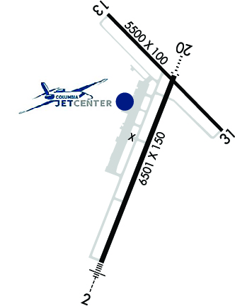
RWY 02/2 0 PCR VALUE: 403/R/D/W/T
RWY 13/3 1 PCR VALUE: 386/R/B/W/T
Airport Communications & Frequencies:
ATIS Frequencies:   Hours(local) of Operation: CONTINUOUS
128.45
COLUMBIA Tower Frequencies:   Hours(local) of operation: 0700-2100   
119.3
363.25
COLUMBIA Ground Frequencies:
121.6
CTAF Frequency:
119.300
Unicom Frequency:
122.950
MIZZU Primary Approach Frequencies:  
124.375
353.925
MIZZU Primary Departure Frequencies:  
124.375
353.925
Runway Identifications
Runway Identification: 02/20
Length: 7401 ft
Width: 150 ft
Surface: CONCRETE-GOOD CONDITION
Edge lights: High Intensity

Treatment: GROOVED

 Runway: 02   Runway: 20
Mag heading: 21°Mag heading: 201°
Rwy Slope: .05% UpRwy Slope: -.05% Down
Approach: ILS/DMEApproach:
Pattern: Left TrafficPattern: Left Traffic
Markings: PRECISION INSTRUMENTMarkings: PRECISION INSTRUMENT
Marking Condition: GOODMarking Condition: GOOD
Arresting Dev: Arresting Dev:
Lat & Long: N3848.3  W09213.4Lat. & Long.: N3849.4  W09212.9
Elev: 882.2 ft. MSLElev: 886.1 ft. MSL
TCH: TCH: 45 ft. AGL
Visual Glide Path: Visual Glide Path: 3.00 degrees
Displaced Threshold: NoDisplaced Threshold: No
Touchdown Zone: YESTouchdown Zone: YES
Touchdown Elev.: 889.3 feetTouchdown Elev.: 889.1 feet
Visual Glide Slope: Visual Glide Slope: 4-Light PAPI on LEFT side of Runway
RVR Equipment: TOUCHDOWNRVR Equipment:
RVV Equipment: NORVV Equipment: NO
Approach Lights: MALSR - 1,400 foot medium intensity approach lighting system with runway alignment indicator lightsApproach Lights:
REIL: NOREIL: YES
Centerline Lights: NOCenterline Lights: NO
Touchdown lights: NOTouchdown lights: NO
Runway Category: Precision Instrument RunwayRunway Category: D
Declared Distances: Declared Distances:
Runway Identification: 13/31
Length: 5500 ft
Width: 100 ft
Surface: CONCRETE
Edge lights: Medium Intensity

Treatment: GROOVED

 Runway: 13   Runway: 31
Mag heading: 135°Mag heading: 315°
Rwy Slope: -.05% DownRwy Slope: .05% Up
Approach: Approach:
Pattern: Left TrafficPattern: Left Traffic
Markings: NONPRECISION INSTRUMENTMarkings: NONPRECISION INSTRUMENT
Marking Condition: GOODMarking Condition: GOOD
Arresting Dev: Arresting Dev:
Lat & Long: N3849.6  W09213.4Lat. & Long.: N3849.0  W09212.6
Elev: 888.2 ft. MSLElev: 885.6 ft. MSL
TCH: 45 ft. AGLTCH: 45 ft. AGL
Visual Glide Path: 3.00 degreesVisual Glide Path: 3.00 degrees
Displaced Threshold: NoDisplaced Threshold: No
Touchdown Zone: YESTouchdown Zone: YES
Touchdown Elev.: 888.2 feetTouchdown Elev.: 886.4 feet
Visual Glide Slope: 4-Light PAPI on LEFT side of RunwayVisual Glide Slope: 4-Light PAPI on LEFT side of Runway
RVR Equipment: RVR Equipment:
RVV Equipment: NORVV Equipment: NO
Approach Lights: Approach Lights:
REIL: YESREIL: YES
Centerline Lights: NOCenterline Lights: NO
Touchdown lights: NOTouchdown lights: NO
Runway Category: Runway with a Non-precision Approach having visibility minimums greater than 3/4 mileRunway Category: Runway with a Non-precision Approach having visibility minimums greater than 3/4 mile
Declared Distances: TORA:5500' TODA:5500' ASDA:5500' LDA:5500'Declared Distances: TORA:5500' TODA:5500' ASDA:5500' LDA:5500'
C:72/P: