Current Weather/Notams (Metars, TAFs, Notams, NWS Forecast, PIREPS, and nearby weather)
Customs Information Send updates to Support@FltPlan.com
Customs Not Available
Database effective 04/18/2024
Airport Diagram might not be current.
|
| Facility Name: | CHANUTE MARTIN JOHNSON |
| City Name: | CHANUTE |
| County: | NEOSHO |
| State abbrev: | KS |
| State Name: | KANSAS |
| | |
| Ownership: | PUBLICLY OWNED |
| Use: | OPEN TO THE PUBLIC |
| Owner's Name: | CITY OF CHANUTE |
| Address: | MEMORIAL BLDG |
| | CHANUTE, KS 66720 |
| Owner's Phone: | 620-431-5296 |
| | |
| Manager's Name: | RYAN FOLMER |
| Address: | 800 S. COUNTRY CLUB ROAD |
| | CHANUTE, KS 66720 |
| Phone: | 620-305-9689 |
| | |
| FAA Region: | CENTRAL |
| FAA Field Office: | NONE |
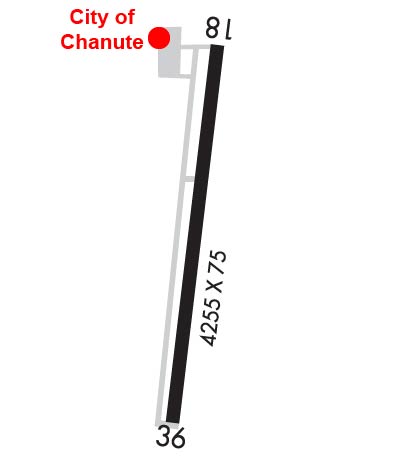
Runway Identifications
Runway Identification: 18/36Length: 4254 ft
Width: 75 ft
Surface: ASPHALT-GOOD CONDITION
Edge lights: Medium IntensityTreatment: NONE
Weight: PCN 5 /F/C/Y/U
| | Runway: 18 | | Runway: 36 |
| Mag heading: | 182° | Mag heading: | 2° |
| Rwy Slope: | .45% Up | Rwy Slope: | -.45% Down |
| Approach: | | Approach: | |
| Pattern: | Left Traffic | Pattern: | Left Traffic |
| Markings: | NONPRECISION INSTRUMENT | Markings: | NONPRECISION INSTRUMENT |
| Marking Condition: | FAIR | Marking Condition: | FAIR |
| Arresting Dev: | | Arresting Dev: | |
| Lat & Long: | N3740.4 W09529.2 | Lat. & Long.: | N3739.7 W09529.3 |
| Elev: | 982.1 ft. MSL | Elev: | 1001.3 ft. MSL |
| TCH: | 40 ft. AGL | TCH: | 40 ft. AGL |
| Visual Glide Path: | 3.00 degrees | Visual Glide Path: | 3.00 degrees |
| Displaced Threshold: | No | Displaced Threshold: | 269 feet |
| Touchdown Zone: | YES | Touchdown Zone: | YES |
| Touchdown Elev.: | 993.1 feet | Touchdown Elev.: | 1001.3 feet |
| Visual Glide Slope: | 2-Light PAPI on LEFT side of Runway | Visual Glide Slope: | 2-Light PAPI on LEFT side of Runway |
| RVR Equipment: | | RVR Equipment: | |
| RVV Equipment: | NO | RVV Equipment: | NO |
| Approach Lights: | | Approach Lights: | |
| REIL: | YES | REIL: | YES |
| Centerline Lights: | NO | Centerline Lights: | NO |
| Touchdown lights: | NO | Touchdown lights: | NO |
| Runway Category: | Runway with a Non-precision Approach | Runway Category: | Runway with a Non-precision Approach |
| Declared Distances: | | Declared Distances: | |
| Obstructions: | TREE | Obstructions: | RR |
| Marked: | NOT Marked/Lighted | Marked: | NOT Marked/Lighted |
| Clearance slope: | 10:1 | Clearance slope: | 3:1; APCH RATIO 32:1 FROM DSPLCD THR. |
| Obstruction height: | 48 feet AGL | Obstruction height: | 23 feet AGL |
| Dist. from runway: | 693 feet | Dist. from runway: | 270 feet |
| Centerline offset: | 190 left of centerline | Centerline offset: | |
| Comments: | +25 FT TREE 173 FRM AER 18, 190 FT L OF CL. | Comments: | |