KCNO

CHINO
CHINO
CA
Time Zone: Pacific
Lat: N 3358.5
Long: W 11738.2
Elev: 650
Var: -14
Longest Runway: 7000
Dept. ATIS: 125.85
Arr. ATIS: 125.85
AWOS: 127.07
Ground: 121.6
Tower: 118.5

FBO & Flight Services info for KCNO

FBOs: Update your Fuel Prices
Flying Tigers Aviation FBO is located within Chino Airport in Chino, California. Our retro-style state-of-the-art facilities offer everything you need from fuel for your plane to snacks for the crew.
Ph: 909-606-3300 Fax: 909-606-0173
-
WebsiteE-Mail
                     
Service
Jet
100LL
SAF
MoGas
Fuel Avail: PRIST+ $0.12/gal.
Full5.456.31    Last Update: 04/22/2024 15:47
PRICES GUARANTEED by FBO.
Self  6.11    
Misc. Info: Address: 7000 MERRILL AVE   BOX 27 BLDGEB 199, CHINO, CA 91710

THRESHOLD AV GRPPh: 909-606-6164 Fax: 909-606-6170 Freq: 128.92
Service
Jet
100LL
SAF
MoGas
Fuel Avail: PRIST+$.0.08/gal CASH DISCOUNT ON 100LL. 24 HRS PHONE
Full5.526.49    Last Update: 04/09/2024 15:57  
Self        
 Address: 8352 KIMBALL AVE F350 HANGAR 3,   CHINO, CA 91708
CHINO FUEL SVCES.Ph: 909-597-6566 Fax: 909-597-6657 Freq: 129.77
Service
Jet
100LL
SAF
MoGas
Fuel Avail: PRIST+$0.05/gal. HRS. 6am to 6pm Two 100LL Self Service 24/7
Full5.356.21    Last Update: 04/20/2024 17:06  
Self  6.01    
 Address: 8348 KIMBALL AVE HANGAR 1,   CHINO, CA 91710
ASOSPh: 909-393-5823
-
Freq: 127.07  
If you are an FBO, call 1-203-262-1700 to update your info or email: FltPlan.Advertising@garmin.com
Advertise your FBO on FltPlan.com

Runway & Approach Info for KCNO
Rwy
Length
Land Dist**
Approach*
  Rwy
Length
Land Dist**
Approach*
03
4919x150  4919'          
 
  
21
  4919x150  4919'          
 
08L
4858x150  4858'          
 
  
26R
  4858x150  4858'          
ILS
 111.50 - 255°  
08R
7000x150  7000'          
 
  
26L
  7000x150  7000'          
 
 * only ILS, LOC, LDA, and SDF approaches to a specific runway are shown
** For any Declared Landing Distance Available, please see A/FD or Approach plates
Runway Weight Capability (lbs.) Help
Runway IDSingle WheelDouble WheelDouble Tandem WheelDual Double Wheel
03/2121,000130,000N/A50,000
08L/26R12,000N/AN/AN/A
08R/26L75,000150,000215,000N/A
These numbers are Advisory and are not limits.   The Airport Manager should have more accurate Weight Limits
Approach Charts
Approaches    
Current Weather/Notams
Customs Information Send updates to Support@FltPlan.com
Customs Not Available
Database effective 05/16/2024
Airport Diagram of KCNO
Airport Diagram might not be current.

Facility Name: CHINO
City Name: CHINO
County: SAN BERNARDINO
State abbrev: CA
State Name: CALIFORNIA
   
Ownership: PUBLICLY OWNED
Use: OPEN TO THE PUBLIC
Owner's Name: COUNTY OF SAN BERNARDINO
Address: 7000 MERRILL AVENUE BOX 1
 CHINO, CA 91710-9091
Owner's Phone: 909-597-3910
  
Manager's Name: MAUREEN SNELGROVE; AIRPORT OPERATIONS MANAGER
Address: 777 EAST RIALTO AVE.
 SAN BERNARDINO, CA 92415-0831
Phone: 909-387-8810
   
FAA Region: WESTERN-PACIFIC
FAA Field Office: LAX


Sunrise / Sunset times for CHINO

DateSunriseSunset
04/24/24 Wednesday6:0819:30
04/25/24 Thursday6:0719:30
04/26/24 Friday6:0619:31
04/27/24 Saturday6:0519:32
04/28/24 Sunday6:0419:33
04/29/24 Monday6:0319:33
04/30/24 Tuesday6:0219:34
05/01/24 Wednesday6:0119:35
05/02/24 Thursday6:0019:36
05/03/24 Friday5:5919:37
05/04/24 Saturday5:5819:37
05/05/24 Sunday5:5719:38
05/06/24 Monday5:5619:39
05/07/24 Tuesday5:5519:40

Airport Facilities

Airport Attendance ScheduleCONTINUOUS
Airport Status OPERATIONAL (This Status can change at any time - please check NOTAMS)
Airport Lighting ScheduleWHEN ATCT CLSD MIRL RY 03/21, HIRL RY 08L/26R, MIRL 08R/26L ARE TURNED ON. PAPI RYS 26R, 08R, 26L, 03, 21 AND REIL RYS 03 & 21 OPER CONTINUOUSLY.
Airport Storage AvailableTie Downs, Hanger
Extra Services AvailableAir Freight, Air Ambulance, Avionics, Cargo Handling, Charter, Flight Instruction, Aircraft Rental, Aircraft Sales, Glider Towing
Wind IndicatorYES - (lighted)
Control TowerYES
CTAF Frequency118.500
Unicom Frequency122.950
Rotating Beacon ColorWG
Segmented CircleNO
Landing FeeNO

Airport Inspection Data

Airport InspectedSTATE - performed by STATE AERONAUTICAL PERSONNEL
Inspection Date03/12/2024

Airport Services

Type of Fuel AvailableGrade 100LL, JET A (freeze point -40C); -10SELF-SERVICE FUEL AVBL 24 HRS.
Airframe Repair ServiceMAJOR
Power Plant Repair ServiceMAJOR

Geographic Data

LatitudeN3358.5
LongitudeW11738.2 (ESTIMATED)
Arpt Elevation650ft (SURVEYED)
Magnetic Variation14E
3 miles SEof CHINO
Traffic Pattern Altitude750; TWIN ENGINE TPA 1350 FT AGL.
Sectional ChartLOS ANGELES

Aircraft Data

Operations (Reported)YearlyAvg. Daily
General Aviation Transient 61641169
General Aviation Local 102640281
Air Taxi 3071
Commerical 00
Commuter 00
Military 00
Aircraft based on Field
General Aviation Singles 495
General Aviation Multi 96
Jet Aircraft 67
General Aviation Helicopters 25
Military Aircraft 0
Gliders 0
Ultralights 0

FAA Services

FSS on field NO
FSS tie-in RIVERSIDE
FSS Phone 1-800-WX-BRIEF
Who issues Notams CNO
Notam D service at airport YES
ARTCC Name LOS ANGELES

Federal Status

Airport Certification
Aircraft Rescue & Firefighting IndexNone
Airport of EntryNo
Custom Landing RightsNo
Joint Civil/MilitaryNo
Military Landing rightsYES

Federal Agreements

NATIONAL PLAN OF INTEGRATED AIRPORT SYSTEMS (NPIAS)
GRANT AGREEMENTS UNDER FAAP/ADAP/AIP
SURPLUS PROPERTY AGREEMENT UNDER PUBLIC LAW 289
ASSURANCES PURSUANT TO TITLE VI, CIVIL RIGHTS ACT OF 1964

Remarks

RADIO CONTROLLED AIRCRAFT ACTIVITY BELOW 400 FT AGL 2.5 NM SOUTH OF AIRPORT
BIRDS AND WILDLIFE ON AND INVOF ARPT.
FOR CD WHEN ATCT CLSD CTC SOCAL APCH AT 800-448-3724.
Airport Communications & Frequencies:
ATIS Frequencies:   Hours(local) of Operation: CONTINUOUS
125.85
CHINO Tower Frequencies:   Hours(local) of operation: 0700-2100   
118.5
CHINO Ground Frequencies:
121.6
CTAF Frequency:
118.500
Unicom Frequency:
122.950
SOCAL Primary Approach Frequencies:  
135.4
377.125
377.125
379.25 NE-EAST
SOCAL Primary Departure Frequencies:  
135.4
377.125
377.125
379.25 NE-EAST
Class C Frequencies:
135.4 SOUTH-SW
318.2 NORTH-NE
377.125 SOUTH-SW
379.25 NE-EAST
Runway Identifications
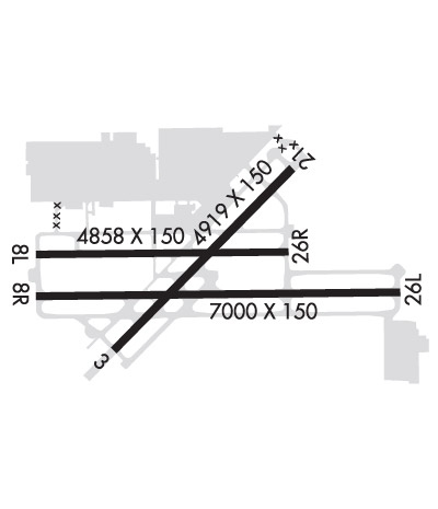
Runway Identification: 03/21
Length: 4919 ft
Width: 150 ft
Surface: ASPHALT-GOOD CONDITION
Edge lights: Medium Intensity

Treatment: NONE

 Runway: 03   Runway: 21
Mag heading: 30°Mag heading: 210°
Rwy Slope: .80% UpRwy Slope: -.80% Down
Approach: Approach:
Pattern: Right TrafficPattern: Left Traffic
Markings: NONPRECISION INSTRUMENTMarkings: NONPRECISION INSTRUMENT
Marking Condition: GOODMarking Condition: GOOD
Arresting Dev: Arresting Dev:
Lat & Long: N3358.2  W11738.5Lat. & Long.: N3358.8  W11737.8
Elev: 610.4 ft. MSLElev: 649.7 ft. MSL
TCH: 40 ft. AGLTCH: 40 ft. AGL
Visual Glide Path: 3.00 degreesVisual Glide Path: 3.00 degrees
Displaced Threshold: NoDisplaced Threshold: No
Touchdown Zone: YESTouchdown Zone: YES
Touchdown Elev.: 635.0 feetTouchdown Elev.: 650.0 feet
Visual Glide Slope: 4-Light PAPI on LEFT side of RunwayVisual Glide Slope: 4-Light PAPI on LEFT side of Runway
RVR Equipment: RVR Equipment:
RVV Equipment: NORVV Equipment: NO
Approach Lights: Approach Lights:
REIL: YESREIL: YES
Centerline Lights: NOCenterline Lights: NO
Touchdown lights: NOTouchdown lights: NO
Runway Category: Runway with a Visual ApproachRunway Category: Runway with a Visual Approach
Declared Distances: Declared Distances:
Runway Identification: 08L/26R
Length: 4858 ft
Width: 150 ft
Surface: ASPHALT-GOOD CONDITION
Edge lights: High Intensity

Treatment: NONE

 Runway: 08L   Runway: 26R
Mag heading: 75°Mag heading: 255°
Rwy Slope: .39% UpRwy Slope: -.39% Down
Approach: Approach: ILS
Pattern: Right TrafficPattern: Left Traffic
Markings: BASICMarkings: PRECISION INSTRUMENT
Marking Condition: GOODMarking Condition: GOOD
Arresting Dev: Arresting Dev:
Lat & Long: N3358.5  W11738.8Lat. & Long.: N3358.6  W11737.8
Elev: 617.2 ft. MSLElev: 636.1 ft. MSL
TCH: 50 ft. AGLTCH: 53 ft. AGL
Visual Glide Path: 3.00 degreesVisual Glide Path: 3.00 degrees
Displaced Threshold: NoDisplaced Threshold: No
Touchdown Zone: YESTouchdown Zone: YES
Touchdown Elev.: 629.6 feetTouchdown Elev.: 636.1 feet
Visual Glide Slope: 4-Light PAPI on LEFT side of RunwayVisual Glide Slope: 4-Light PAPI on LEFT side of Runway
RVR Equipment: RVR Equipment:
RVV Equipment: NORVV Equipment: NO
Approach Lights: Approach Lights:
REIL: NOREIL: NO
Centerline Lights: NOCenterline Lights: NO
Touchdown lights: NOTouchdown lights: NO
Runway Category: Runway with a Visual ApproachRunway Category: Precision Instrument Runway
Declared Distances: Declared Distances:
Obstructions: TREESObstructions: TREES
Marked: NOT Marked/LightedMarked: NOT Marked/Lighted
Clearance slope: 21:1Clearance slope: 32:1
Obstruction height: 65 feet AGLObstruction height: 60 feet AGL
Dist. from runway: 1571 feetDist. from runway: 2150 feet
Centerline offset: 140 left of centerlineCenterline offset: 250 feet left of centerline
Comments: Comments:
Runway Identification: 08R/26L
Length: 7000 ft
Width: 150 ft
Surface: ASPHALT-GOOD CONDITION
Edge lights: Medium Intensity

Treatment: GROOVED

 Runway: 08R   Runway: 26L
Mag heading: 75°Mag heading: 255°
Rwy Slope: .24% UpRwy Slope: -.24% Down
Approach: Approach:
Pattern: Right TrafficPattern: Left Traffic
Markings: NONPRECISION INSTRUMENTMarkings: NONPRECISION INSTRUMENT
Marking Condition: GOODMarking Condition: GOOD
Arresting Dev: Arresting Dev:
Lat & Long: N3358.4  W11738.8Lat. & Long.: N3358.4  W11737.4
Elev: 619.5 ft. MSLElev: 636.5 ft. MSL
TCH: 52 ft. AGLTCH: 55 ft. AGL
Visual Glide Path: 3.00 degreesVisual Glide Path: 3.00 degrees
Displaced Threshold: NoDisplaced Threshold: No
Touchdown Zone: YESTouchdown Zone: YES
Touchdown Elev.: 624.8 feetTouchdown Elev.: 636.5 feet
Visual Glide Slope: 4-Light PAPI on LEFT side of RunwayVisual Glide Slope: 4-Light PAPI on LEFT side of Runway
RVR Equipment: RVR Equipment:
RVV Equipment: NORVV Equipment: NO
Approach Lights: Approach Lights:
REIL: NOREIL: NO
Centerline Lights: NOCenterline Lights: NO
Touchdown lights: NOTouchdown lights: NO
Runway Category: Runway with a Visual ApproachRunway Category: Runway with a Visual Approach
Declared Distances: Declared Distances:
Obstructions: Obstructions: TREES
Marked: Marked: NOT Marked/Lighted
Clearance slope: 50:1Clearance slope: 20:1
Obstruction height: Obstruction height: 55 feet AGL
Dist. from runway: Dist. from runway: 1320 feet
Centerline offset: Centerline offset: 75 feet left of centerline
Comments: Comments:
C:52/P: