Current Weather/Notams (Metars, TAFs, Notams, NWS Forecast, PIREPS, and nearby weather)
Customs Information Send updates to Support@FltPlan.com
Customs Not Available
Database effective 05/16/2024
Airport Diagram might not be current.
|
| Facility Name: | BLOSSER MUNI |
| City Name: | CONCORDIA |
| County: | CLOUD |
| State abbrev: | KS |
| State Name: | KANSAS |
| | |
| Ownership: | PUBLICLY OWNED |
| Use: | OPEN TO THE PUBLIC |
| Owner's Name: | CITY OF CONCORDIA |
| Address: | BOX 603 (CITY OFFICE) |
| | CONCORDIA, KS 66901 |
| Owner's Phone: | |
| | |
| Manager's Name: | RON COPPLE |
| Address: | 701 WASHINGTON |
| | CONCORDIA, KS 66901 |
| Phone: | 785-243-2670 |
| | |
| FAA Region: | CENTRAL |
| FAA Field Office: | NONE |
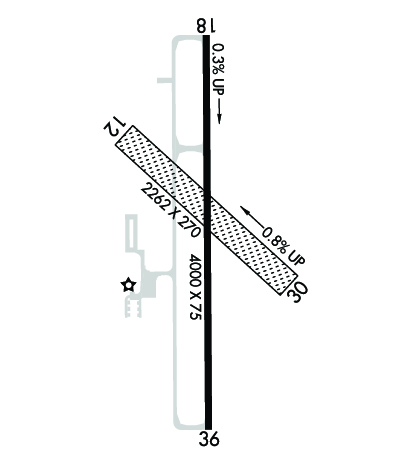
Runway Identifications
Runway Identification: 12/30Length: 2040 ft
Width: 60 ft
Surface: GRASS-GOOD CONDITION
Edge lights: Treatment: NONE
| | Runway: 12 | | Runway: 30 |
| Mag heading: | 126° | Mag heading: | 306° |
| Rwy Slope: | -.71% Down | Rwy Slope: | .71% Up |
| Approach: | | Approach: | |
| Pattern: | Left Traffic | Pattern: | Left Traffic |
| Markings: | NONE | Markings: | NONE |
| Marking Condition: | | Marking Condition: | |
| Arresting Dev: | | Arresting Dev: | |
| Lat & Long: | N3933.1 W09739.3 | Lat. & Long.: | N3932.9 W09739.0 |
| Elev: | 1470.8 ft. MSL | Elev: | 1456.3 ft. MSL |
| TCH: | | TCH: | |
| Visual Glide Path: | | Visual Glide Path: | |
| Displaced Threshold: | No | Displaced Threshold: | No |
| Touchdown Zone: | YES | Touchdown Zone: | YES |
| Touchdown Elev.: | 1470.8 feet | Touchdown Elev.: | 1470.8 feet |
| Visual Glide Slope: | | Visual Glide Slope: | |
| RVR Equipment: | | RVR Equipment: | |
| RVV Equipment: | NO | RVV Equipment: | NO |
| Approach Lights: | | Approach Lights: | |
| REIL: | NO | REIL: | NO |
| Centerline Lights: | NO | Centerline Lights: | NO |
| Touchdown lights: | NO | Touchdown lights: | NO |
| Runway Category: | Runway with a Visual Approach | Runway Category: | Runway with a Visual Approach |
| Declared Distances: | | Declared Distances: | |
| Obstructions: | | Obstructions: | PLINE |
| Marked: | | Marked: | MARKED |
| Clearance slope: | 50:1 | Clearance slope: | 31:1 |
| Obstruction height: | | Obstruction height: | 17 feet AGL |
| Dist. from runway: | | Dist. from runway: | 534 feet |
| Centerline offset: | | Centerline offset: | |
| Comments: | | Comments: | |
Runway Identification: 18/36Length: 4000 ft
Width: 75 ft
Surface: ASPHALT-GOOD CONDITION
Edge lights: Medium IntensityTreatment: NONE
Weight: PCN 5 /F/C/Y/U
| | Runway: 18 | | Runway: 36 |
| Mag heading: | 174° | Mag heading: | 354° |
| Rwy Slope: | .31% Up | Rwy Slope: | -.31% Down |
| Approach: | | Approach: | |
| Pattern: | Left Traffic | Pattern: | Left Traffic |
| Markings: | NONPRECISION INSTRUMENT | Markings: | NONPRECISION INSTRUMENT |
| Marking Condition: | GOOD | Marking Condition: | GOOD |
| Arresting Dev: | | Arresting Dev: | |
| Lat & Long: | N3933.3 W09739.1 | Lat. & Long.: | N3932.7 W09739.1 |
| Elev: | 1475.6 ft. MSL | Elev: | 1488.1 ft. MSL |
| TCH: | 35 ft. AGL | TCH: | 40 ft. AGL |
| Visual Glide Path: | 3.00 degrees | Visual Glide Path: | 3.00 degrees |
| Displaced Threshold: | No | Displaced Threshold: | No |
| Touchdown Zone: | YES | Touchdown Zone: | YES |
| Touchdown Elev.: | 1475.6 feet | Touchdown Elev.: | 1488.1 feet |
| Visual Glide Slope: | 4-Light PAPI on LEFT side of Runway; PAPI UNUSBL BYD 4 DEGS LEFT OF CNTRLN. | Visual Glide Slope: | 4-Light PAPI on LEFT side of Runway; PAPI UNUSBL BYD 6 DEGS LEFT OF CNTRLN. |
| RVR Equipment: | | RVR Equipment: | |
| RVV Equipment: | NO | RVV Equipment: | NO |
| Approach Lights: | | Approach Lights: | |
| REIL: | YES | REIL: | YES |
| Centerline Lights: | NO | Centerline Lights: | NO |
| Touchdown lights: | NO | Touchdown lights: | NO |
| Runway Category: | Runway with a Non-precision Approach | Runway Category: | Runway with a Non-precision Approach |
| Declared Distances: | | Declared Distances: | |
| Obstructions: | | Obstructions: | TREE |
| Marked: | | Marked: | NOT Marked/Lighted |
| Clearance slope: | 20:1 | Clearance slope: | 26:1 |
| Obstruction height: | | Obstruction height: | 69 feet AGL |
| Dist. from runway: | | Dist. from runway: | 2010 feet |
| Centerline offset: | | Centerline offset: | 319 feet left of centerline |
| Comments: | | Comments: | |

