Current Weather/Notams (Metars, TAFs, Notams, NWS Forecast, PIREPS, and nearby weather)
Customs Information Send updates to Support@FltPlan.com
Customs Not Available
Database effective 05/16/2024
Airport Diagram might not be current.
|
| Facility Name: | MYERS FLD |
| City Name: | CANBY |
| County: | YELLOW MEDICINE |
| State abbrev: | MN |
| State Name: | MINNESOTA |
| | |
| Ownership: | PUBLICLY OWNED |
| Use: | OPEN TO THE PUBLIC |
| Owner's Name: | CITY OF CANBY |
| Address: | 110 OSCAR AVE N |
| | CANBY, MN 56220-1332 |
| Owner's Phone: | 507-223-7295 |
| | |
| Manager's Name: | MATT WAGNER |
| Address: | 2142 EDGEWATER DR |
| | GARY, SD 57237-5530 |
| Phone: | 507-828-0323 |
| | |
| FAA Region: | GREAT LAKES |
| FAA Field Office: | DMA |
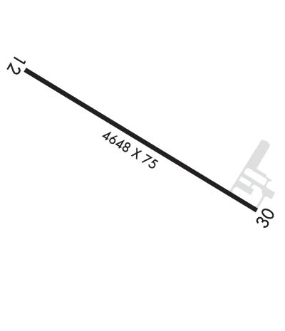
Runway Identifications
Runway Identification: 12/30Length: 4648 ft
Width: 75 ft
Surface: ASPHALT-FAIR CONDITION
Edge lights: Medium IntensityTreatment: NONE
| | Runway: 12 | | Runway: 30 |
| Mag heading: | 118° | Mag heading: | 298° |
| Rwy Slope: | -.19% Down | Rwy Slope: | .19% Up |
| Approach: | | Approach: | |
| Pattern: | Left Traffic | Pattern: | Left Traffic |
| Markings: | NONPRECISION INSTRUMENT | Markings: | NONPRECISION INSTRUMENT |
| Marking Condition: | GOOD | Marking Condition: | GOOD |
| Arresting Dev: | | Arresting Dev: | |
| Lat & Long: | N4444.0 W09616.4 | Lat. & Long.: | N4443.6 W09615.5 |
| Elev: | 1194.1 ft. MSL | Elev: | 1185.1 ft. MSL |
| TCH: | 25 ft. AGL | TCH: | 29 ft. AGL |
| Visual Glide Path: | 3.00 degrees | Visual Glide Path: | 3.00 degrees |
| Displaced Threshold: | No | Displaced Threshold: | 239 feet |
| Touchdown Zone: | YES | Touchdown Zone: | YES |
| Touchdown Elev.: | 1194.1 feet | Touchdown Elev.: | 1191.5 feet |
| Visual Glide Slope: | 4-Light PAPI on LEFT side of Runway | Visual Glide Slope: | 4-Light PAPI on LEFT side of Runway |
| RVR Equipment: | | RVR Equipment: | |
| RVV Equipment: | NO | RVV Equipment: | NO |
| Approach Lights: | | Approach Lights: | |
| REIL: | YES | REIL: | YES |
| Centerline Lights: | NO | Centerline Lights: | NO |
| Touchdown lights: | NO | Touchdown lights: | NO |
| Runway Category: | Runway with a Non-precision Approach | Runway Category: | Runway with a Non-precision Approach |
| Declared Distances: | | Declared Distances: | |
| Obstructions: | | Obstructions: | ROAD |
| Marked: | | Marked: | NOT Marked/Lighted |
| Clearance slope: | 20:1 | Clearance slope: | 9:1; APCH SLP 25:1 TO DTHR. |
| Obstruction height: | | Obstruction height: | 17 feet AGL |
| Dist. from runway: | | Dist. from runway: | 360 feet |
| Centerline offset: | | Centerline offset: | 265 feet right of centerline |
| Comments: | | Comments: | |

