Current Weather/Notams (Metars, TAFs, Notams, NWS Forecast, PIREPS, and nearby weather)
Customs Information Send updates to Support@FltPlan.com
Customs Not Available
Database effective 04/18/2024
Airport Diagram might not be current.
|
| Facility Name: | CLINTONVILLE MUNI |
| City Name: | CLINTONVILLE |
| County: | WAUPACA |
| State abbrev: | WI |
| State Name: | WISCONSIN |
| | |
| Ownership: | PUBLICLY OWNED |
| Use: | OPEN TO THE PUBLIC |
| Owner's Name: | CITY OF CLINTONVILLE |
| Address: | CITY HALL; 50 TENTH STREET |
| | CLINTONVILLE, WI 54929 |
| Owner's Phone: | 715-823-7600 |
| | |
| Manager's Name: | CAZ MUSKE |
| Address: | 50 10TH ST |
| | CLINTONVILLE, WI 54929 |
| Phone: | (715) 250-0220 |
| | |
| FAA Region: | GREAT LAKES |
| FAA Field Office: | CHI |
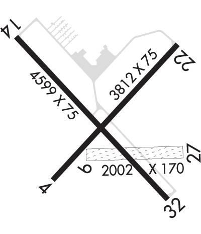
Runway Identifications
Runway Identification: 04/22Length: 3812 ft
Width: 75 ft
Surface: ASPHALT-GOOD CONDITION
Edge lights: Medium IntensityTreatment: NONE
| | Runway: 04 | | Runway: 22 |
| Mag heading: | 45° | Mag heading: | 225° |
| Rwy Slope: | -.40% Down | Rwy Slope: | .40% Up |
| Approach: | | Approach: | |
| Pattern: | Left Traffic | Pattern: | Left Traffic |
| Markings: | NONPRECISION INSTRUMENT | Markings: | NONPRECISION INSTRUMENT |
| Marking Condition: | GOOD | Marking Condition: | GOOD |
| Arresting Dev: | | Arresting Dev: | |
| Lat & Long: | N4436.6 W08844.1 | Lat. & Long.: | N4437.1 W08843.5 |
| Elev: | 825.9 ft. MSL | Elev: | 810.6 ft. MSL |
| TCH: | | TCH: | |
| Visual Glide Path: | | Visual Glide Path: | |
| Displaced Threshold: | No | Displaced Threshold: | No |
| Touchdown Zone: | YES | Touchdown Zone: | YES |
| Touchdown Elev.: | 825.9 feet | Touchdown Elev.: | 820.8 feet |
| Visual Glide Slope: | | Visual Glide Slope: | |
| RVR Equipment: | | RVR Equipment: | |
| RVV Equipment: | NO | RVV Equipment: | NO |
| Approach Lights: | | Approach Lights: | |
| REIL: | NO | REIL: | NO |
| Centerline Lights: | NO | Centerline Lights: | NO |
| Touchdown lights: | NO | Touchdown lights: | NO |
| Runway Category: | Runway with a Non-precision Approach | Runway Category: | Runway with a Non-precision Approach |
| Declared Distances: | | Declared Distances: | |
Runway Identification: 09/27Length: 2002 ft
Width: 170 ft
Surface: GRASS-FAIR CONDITION
Edge lights: Treatment: NONE
| | Runway: 09 | | Runway: 27 |
| Mag heading: | 91° | Mag heading: | 270° |
| Rwy Slope: | -.32% Down | Rwy Slope: | .32% Up |
| Approach: | | Approach: | |
| Pattern: | Left Traffic | Pattern: | Left Traffic |
| Markings: | NONE | Markings: | NONE |
| Marking Condition: | MKD WITH WHITE CONES. | Marking Condition: | MKD WITH WHITE CONES. |
| Arresting Dev: | | Arresting Dev: | |
| Lat & Long: | N4436.7 W08844.0 | Lat. & Long.: | N4436.7 W08843.5 |
| Elev: | 818.4 ft. MSL | Elev: | 811.9 ft. MSL |
| TCH: | | TCH: | |
| Visual Glide Path: | | Visual Glide Path: | |
| Displaced Threshold: | No | Displaced Threshold: | No |
| Touchdown Zone: | YES | Touchdown Zone: | YES |
| Touchdown Elev.: | 818.4 feet | Touchdown Elev.: | 818.4 feet |
| Visual Glide Slope: | | Visual Glide Slope: | |
| RVR Equipment: | | RVR Equipment: | |
| RVV Equipment: | NO | RVV Equipment: | NO |
| Approach Lights: | | Approach Lights: | |
| REIL: | NO | REIL: | NO |
| Centerline Lights: | NO | Centerline Lights: | NO |
| Touchdown lights: | NO | Touchdown lights: | NO |
| Runway Category: | Runway with a Visual Approach | Runway Category: | Runway with a Visual Approach |
| Declared Distances: | | Declared Distances: | |
Runway Identification: 14/32Length: 4599 ft
Width: 75 ft
Surface: ASPHALT-FAIR CONDITION
Edge lights: Medium IntensityTreatment: NONE
| | Runway: 14 | | Runway: 32 |
| Mag heading: | 139° | Mag heading: | 319° |
| Rwy Slope: | -.08% Down | Rwy Slope: | .08% Up |
| Approach: | | Approach: | |
| Pattern: | Left Traffic | Pattern: | Left Traffic |
| Markings: | NONPRECISION INSTRUMENT | Markings: | NONPRECISION INSTRUMENT |
| Marking Condition: | GOOD | Marking Condition: | GOOD |
| Arresting Dev: | | Arresting Dev: | |
| Lat & Long: | N4437.1 W08844.3 | Lat. & Long.: | N4436.5 W08843.6 |
| Elev: | 818.5 ft. MSL | Elev: | 814.7 ft. MSL |
| TCH: | | TCH: | 26 ft. AGL |
| Visual Glide Path: | | Visual Glide Path: | 3.00 degrees |
| Displaced Threshold: | No | Displaced Threshold: | No |
| Touchdown Zone: | YES | Touchdown Zone: | YES |
| Touchdown Elev.: | 822.3 feet | Touchdown Elev.: | 820.6 feet |
| Visual Glide Slope: | | Visual Glide Slope: | 2-Light PAPI on LEFT side of Runway |
| RVR Equipment: | | RVR Equipment: | |
| RVV Equipment: | NO | RVV Equipment: | NO |
| Approach Lights: | | Approach Lights: | |
| REIL: | NO | REIL: | YES |
| Centerline Lights: | NO | Centerline Lights: | NO |
| Touchdown lights: | NO | Touchdown lights: | NO |
| Runway Category: | Runway with a Non-precision Approach having visibility minimums greater than 3/4 mile | Runway Category: | Runway with a Non-precision Approach having visibility minimums greater than 3/4 mile |
| Declared Distances: | | Declared Distances: | |
| Obstructions: | TREES | Obstructions: | TREES |
| Marked: | NOT Marked/Lighted | Marked: | NOT Marked/Lighted |
| Clearance slope: | 13:1 | Clearance slope: | 4:1 |
| Obstruction height: | 79 feet AGL | Obstruction height: | 37 feet AGL |
| Dist. from runway: | 1300 feet | Dist. from runway: | 355 feet |
| Centerline offset: | 375 right of centerline | Centerline offset: | 260 feet left of centerline |
| Comments: | | Comments: | |

