Current Weather/Notams (Metars, TAFs, Notams, NWS Forecast, PIREPS, and nearby weather)
Customs Information Send updates to Support@FltPlan.com
Customs Not Available
Database effective 05/16/2024
Airport Diagram might not be current.
|
| Facility Name: | OUTLAW FLD |
| City Name: | CLARKSVILLE |
| County: | MONTGOMERY |
| State abbrev: | TN |
| State Name: | TENNESSEE |
| | |
| Ownership: | PUBLICLY OWNED |
| Use: | OPEN TO THE PUBLIC |
| Owner's Name: | CLARKSVILLE MONTGOMERY COUNTY RAA |
| Address: | 200 A OUTLAW FIELD ROAD |
| | CLARKSVILLE, TN 37042 |
| Owner's Phone: | 931-431-2080 |
| | |
| Manager's Name: | JOHN PATTERSON |
| Address: | 200 AIRPORT ROAD - BLDG 1 |
| | CLARKSVILLE, TN 37042 |
| Phone: | 931-431-2080 |
| | |
| FAA Region: | SOUTHERN |
| FAA Field Office: | MEM |
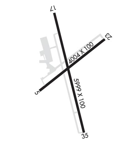
Runway Identifications
Runway Identification: 05/23Length: 4004 ft
Width: 100 ft
Surface: ASPHALT-FAIR CONDITION
Edge lights: Treatment: NONE
| | Runway: 05 | | Runway: 23 |
| Mag heading: | 53° | Mag heading: | 233° |
| Rwy Slope: | -.16% Down | Rwy Slope: | .16% Up |
| Approach: | | Approach: | |
| Pattern: | Right Traffic | Pattern: | Left Traffic |
| Markings: | NONPRECISION INSTRUMENT | Markings: | NONPRECISION INSTRUMENT |
| Marking Condition: | POOR; PEELING & FADED. | Marking Condition: | POOR; PEELING & FADED. |
| Arresting Dev: | | Arresting Dev: | |
| Lat & Long: | N3637.1 W08725.2 | Lat. & Long.: | N3637.6 W08724.6 |
| Elev: | 539.3 ft. MSL | Elev: | 532.7 ft. MSL |
| TCH: | | TCH: | |
| Visual Glide Path: | | Visual Glide Path: | |
| Displaced Threshold: | 402 feet | Displaced Threshold: | 503 feet |
| Touchdown Zone: | YES | Touchdown Zone: | YES |
| Touchdown Elev.: | 544.3 feet | Touchdown Elev.: | 544.3 feet |
| Visual Glide Slope: | | Visual Glide Slope: | |
| RVR Equipment: | | RVR Equipment: | |
| RVV Equipment: | NO | RVV Equipment: | NO |
| Approach Lights: | | Approach Lights: | |
| REIL: | NO | REIL: | NO |
| Centerline Lights: | NO | Centerline Lights: | NO |
| Touchdown lights: | NO | Touchdown lights: | NO |
| Runway Category: | Runway with a Visual Approach | Runway Category: | Runway with a Visual Approach |
| Declared Distances: | TORA:4004' TODA:4004' ASDA:3501' LDA:3099' | Declared Distances: | TORA:4004' TODA:4004' ASDA:3602' LDA:3099' |
| Obstructions: | TREE | Obstructions: | TREE |
| Marked: | NOT Marked/Lighted | Marked: | NOT Marked/Lighted |
| Clearance slope: | 3:1; APCH RATIO 12:1 TO DSPLCD THR. | Clearance slope: | 9:1; APCH RATIO 19:1 TO DSPLCD THR. |
| Obstruction height: | 44 feet AGL | Obstruction height: | 86 feet AGL |
| Dist. from runway: | 365 feet | Dist. from runway: | 1057 feet |
| Centerline offset: | 63 right of centerline | Centerline offset: | 28 feet left of centerline |
| Comments: | FENCE 100 FT FM RWY END. | Comments: | FENCE 100 FT FM RWY END. |
Runway Identification: 17/35Length: 5999 ft
Width: 100 ft
Surface: ASPHALT
Edge lights: Medium IntensityTreatment: NONE
Weight: PCN 27 /R/C/X/T
| | Runway: 17 | | Runway: 35 |
| Mag heading: | 167° | Mag heading: | 347° |
| Rwy Slope: | .18% Up | Rwy Slope: | -.18% Down |
| Approach: | | Approach: | LOCALIZER |
| Pattern: | Left Traffic | Pattern: | Right Traffic |
| Markings: | NONPRECISION INSTRUMENT | Markings: | NONPRECISION INSTRUMENT |
| Marking Condition: | GOOD | Marking Condition: | GOOD |
| Arresting Dev: | | Arresting Dev: | |
| Lat & Long: | N3637.8 W08725.1 | Lat. & Long.: | N3636.8 W08724.8 |
| Elev: | 538.0 ft. MSL | Elev: | 549.0 ft. MSL |
| TCH: | 52 ft. AGL | TCH: | 54 ft. AGL |
| Visual Glide Path: | 3.00 degrees | Visual Glide Path: | 3.00 degrees |
| Displaced Threshold: | No | Displaced Threshold: | No |
| Touchdown Zone: | YES | Touchdown Zone: | YES |
| Touchdown Elev.: | 541.3 feet | Touchdown Elev.: | 549.9 feet |
| Visual Glide Slope: | 2-Light PAPI on LEFT side of Runway; PAPI RWY 17 UNUSBL BYD 9 DEGS RIGHT OF CNTLN. | Visual Glide Slope: | 2-Light PAPI on LEFT side of Runway |
| RVR Equipment: | | RVR Equipment: | |
| RVV Equipment: | NO | RVV Equipment: | NO |
| Approach Lights: | | Approach Lights: | MALS - 1,400 foot medium intensity approach lighting system |
| REIL: | YES | REIL: | NO |
| Centerline Lights: | NO | Centerline Lights: | NO |
| Touchdown lights: | NO | Touchdown lights: | NO |
| Runway Category: | Runway with a Non-precision Approach having visibility minimums greater than 3/4 mile | Runway Category: | D |
| Declared Distances: | | Declared Distances: | |
| Obstructions: | TREES | Obstructions: | TREES |
| Marked: | NOT Marked/Lighted | Marked: | NOT Marked/Lighted |
| Clearance slope: | 20:1 | Clearance slope: | 26:1 |
| Obstruction height: | 103 feet AGL | Obstruction height: | 75 feet AGL |
| Dist. from runway: | 2334 feet | Dist. from runway: | 2156 feet |
| Centerline offset: | 463 left of centerline | Centerline offset: | 377 feet left of centerline |
| Comments: | | Comments: | |

