Click here for more info on on SMS!

KCKC

GRAND MARAIS/COOK COUNTY
GRAND MARAIS
MN
Time Zone: Central
Lat: N 4750.3
Long: W 09023.1
Elev: 1803
Var: +01
Longest Runway: 5002
AWOS: 119.92
CTAF: 122.8

FBO & Flight Services info for KCKC

FBOs: Update your Fuel Prices
We are a small, family owned restoration shop located in Grand Marais, MN about 10 miles from the shores of Lake Superior and 5 miles from the Boundry Waters Canoe Area. We specialize in antique and classic aircraft restoration, aircraft maintenance (all phases), aircraft modifications, custom paint schemes and upholstery.

We carry 100LL and Jet A fuel.
Ph: 218-387-3024
-
Freq: 122.8WebsiteE-Mail
Service
Jet
100LL
SAF
MoGas
Fuel Avail: PRIST PREMIXED
Full6.826.31    Last Update: 04/10/2024 10:47

Self        
Misc. Info: Address: 123 AIRPORT RD,   GRAND MARAIS, MN 55604

AWOSPh: 218-387-1971
-
Freq: 119.92  
If you are an FBO, call 1-203-262-1700 to update your info or email: FltPlan.Advertising@garmin.com
Advertise your FBO on FltPlan.com

Runway & Approach Info for KCKC
Rwy
Length
Land Dist**
Approach*
  Rwy
Length
Land Dist**
Approach*
10
5002x100  5002'          
 
  
28
  5002x100  5002'          
 
 * only ILS, LOC, LDA, and SDF approaches to a specific runway are shown
** For any Declared Landing Distance Available, please see A/FD or Approach plates
Runway Weight Capability (lbs.) Help
Runway IDSingle WheelDouble WheelDouble Tandem WheelDual Double Wheel
10/28N/AN/AN/AN/A
These numbers are Advisory and are not limits.   The Airport Manager should have more accurate Weight Limits
Approach Charts
Approaches    
Current Weather/Notams
Customs Information Send updates to Support@FltPlan.com
Phone 218-475-2244
Fax 218-475-2651

Comments Sun-Sat *On call basis. *1 hr advance notice required *Call prior to 1700 on preceding weekday.
Database effective 05/16/2024
Airport Diagram of KCKC
Airport Diagram might not be current.

Facility Name: GRAND MARAIS/COOK COUNTY
City Name: GRAND MARAIS
County: COOK
State abbrev: MN
State Name: MINNESOTA
   
Ownership: PUBLICLY OWNED
Use: OPEN TO THE PUBLIC
Owner's Name: COOK COUNTY
Address: 411 W 2ND ST
 GRAND MARAIS, MN 55604-2307
Owner's Phone: 218-837-3000
  
Manager's Name: RODNEY ROY
Address: 123 AIRPORT RD
 GRAND MARAIS, MN 55604-2304
Phone: 218-387-3024
   
FAA Region: GREAT LAKES
FAA Field Office: DMA


Sunrise / Sunset times for GRAND MARAIS/COOK COUNTY

DateSunriseSunset
04/24/24 Wednesday5:5420:06
04/25/24 Thursday5:5320:07
04/26/24 Friday5:5120:08
04/27/24 Saturday5:4920:10
04/28/24 Sunday5:4720:11
04/29/24 Monday5:4620:13
04/30/24 Tuesday5:4420:14
05/01/24 Wednesday5:4220:15
05/02/24 Thursday5:4120:17
05/03/24 Friday5:3920:18
05/04/24 Saturday5:3820:20
05/05/24 Sunday5:3620:21
05/06/24 Monday5:3520:22
05/07/24 Tuesday5:3320:24

Airport Facilities

Airport Attendance ScheduleMON-SAT 0800-1700, SUN 0900-1700
Airport Status OPERATIONAL (This Status can change at any time - please check NOTAMS)
Airport Lighting ScheduleACTVT OR INCR INTST REIL RWY 10 & 28; PAPI RWY 10 & 28; MIRL RWY 10/28 - CTAF. MIRL RWY 10/28 PRESET LOW INTST.
Airport Storage AvailableTie Downs, Hanger
Extra Services AvailableFlight Instruction, Aircraft Rental, Aircraft Sales, Annual Surveying
Wind IndicatorYES - (lighted)
Control TowerNO
CTAF Frequency122.800
Unicom Frequency122.800
Rotating Beacon ColorWG
Segmented CircleYES
Landing FeeNO

Airport Inspection Data

Airport InspectedSTATE - performed by STATE AERONAUTICAL PERSONNEL
Inspection Date07/14/2022

Airport Services

Type of Fuel AvailableGrade 100LL, JET A (freeze point -40C); -10FOR SVC AFT HRS CALL 218-387-2012.
Airframe Repair ServiceMAJOR
Power Plant Repair ServiceMAJOR

Geographic Data

LatitudeN4750.3
LongitudeW09023.1 (ESTIMATED)
Arpt Elevation1803ft (SURVEYED)
Magnetic Variation01W
7 miles NWof GRAND MARAIS
Traffic Pattern Altitude
Sectional ChartGREEN BAY

Aircraft Data

Operations (Reported)YearlyAvg. Daily
General Aviation Transient 10003
General Aviation Local 22006
Air Taxi 00
Commerical 00
Commuter 00
Military 00
Aircraft based on Field
General Aviation Singles 20
General Aviation Multi 1
Jet Aircraft 0
General Aviation Helicopters 0
Military Aircraft 0
Gliders 0
Ultralights 1

FAA Services

FSS on field NO
FSS tie-in PRINCETON
FSS Phone 1-800-WX-BRIEF
Who issues Notams CKC
Notam D service at airport YES
ARTCC Name MINNEAPOLIS

Federal Status

Airport Certification
Aircraft Rescue & Firefighting IndexNone
Airport of EntryNo
Custom Landing RightsYES
Joint Civil/MilitaryNo
Military Landing rightsYES

Federal Agreements

NATIONAL PLAN OF INTEGRATED AIRPORT SYSTEMS (NPIAS)
GRANT AGREEMENTS UNDER FAAP/ADAP/AIP
CONVEYANCE UNDER SCETION 16, FEDERAL AIRPORT ACT OF 1946 OR SECTION 23, AIRPORT AND AIRWAY DEVELOPMENT ACT OF 1970
ASSURANCES PURSUANT TO TITLE VI, CIVIL RIGHTS ACT OF 1964

Remarks

CUST AVBL MAY 15-OCT 15.
FOR CD IF UNA TO CTC ON FSS FREQ, CTC MINNEAPOLIS ARTCC AT 651-463-5588.
RWY 28 CALM WIND RWY.
Airport Communications & Frequencies:
CTAF Frequency:
122.800
Unicom Frequency:
122.800
Remarks
  • COMMUNICATIONS PRVDD BY PRINCETON RADIO ON FREQ 122.3 (GRAND MARAIS RCO).
  • APCH/DEP SVC PRVDD BY MINNEAPOLIS ARTCC (ZMP) ON FREQS 127.9/281.45 (DULUTH RCAG).
  • Runway Identifications
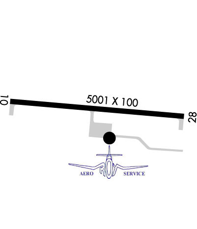
    Runway Identification: 10/28
    Length: 5002 ft
    Width: 100 ft
    Surface: ASPHALT-GOOD CONDITION
    Edge lights: Medium Intensity

    Treatment: NONE

     Runway: 10   Runway: 28
    Mag heading: 96°Mag heading: 276°
    Rwy Slope: -.18% DownRwy Slope: .18% Up
    Approach: Approach:
    Pattern: Left TrafficPattern: Left Traffic
    Markings: NONPRECISION INSTRUMENTMarkings: NONPRECISION INSTRUMENT
    Marking Condition: GOODMarking Condition: GOOD
    Arresting Dev: Arresting Dev:
    Lat & Long: N4750.3  W09023.7Lat. & Long.: N4750.3  W09022.5
    Elev: 1803.1 ft. MSLElev: 1793.9 ft. MSL
    TCH: 41 ft. AGLTCH: 40 ft. AGL
    Visual Glide Path: 3.00 degreesVisual Glide Path: 3.00 degrees
    Displaced Threshold: NoDisplaced Threshold: No
    Touchdown Zone: YESTouchdown Zone: YES
    Touchdown Elev.: 1803.1 feetTouchdown Elev.: 1797.0 feet
    Visual Glide Slope: 4-Light PAPI on LEFT side of RunwayVisual Glide Slope: 4-Light PAPI on LEFT side of Runway
    RVR Equipment: RVR Equipment:
    RVV Equipment: NORVV Equipment: NO
    Approach Lights: Approach Lights:
    REIL: YESREIL: YES
    Centerline Lights: NOCenterline Lights: NO
    Touchdown lights: NOTouchdown lights: NO
    Runway Category: Runway with a Non-precision Approach having visibility minimums greater than 3/4 mileRunway Category: Runway with a Non-precision Approach having visibility minimums greater than 3/4 mile
    Declared Distances: Declared Distances:
    Obstructions: Obstructions: BRUSH
    Marked: Marked: NOT Marked/Lighted
    Clearance slope: 34:1Clearance slope: 15:1
    Obstruction height: Obstruction height: 16 feet AGL
    Dist. from runway: Dist. from runway: 445 feet
    Centerline offset: Centerline offset: 20 feet left of centerline
    Comments: 4 FT BRUSH, 95 FT DIST, 218 FT R.Comments:
    C:2/P: