Click here for more info on on SMS!

KCID

THE EASTERN IOWA
CEDAR RAPIDS
IA
Time Zone: Central
Lat: N 4153.1
Long: W 09142.6
Elev: 869
Var: -02
Longest Runway: 8600
Clr Del: 125.45
Dept. ATIS: 124.15
Arr. ATIS: 124.15
Ground: 121.6
Tower: 118.7

FBO & Flight Services info for KCID

FBOs: Update your Fuel Prices
Passenger terminal & lounge, catering, internet, pilot lounge, hangars, a/c stairs, baggage loader, cargo handling, de-icing, maintenance. We look forward to seeing you at the Eastern Iowa Airport . 04:00-23:00
Ph: 319-366-1925 Fax: 319-366-2474 Freq: 131.0WebsiteE-Mail
                                         
Service
Jet
100LL
SAF
MoGas
Fuel Avail: PRIST +$0.08/gal.
Full7.307.02    Last Update: 04/19/2024 07:53

Self        
Misc. Info: Address: 9430 SHEPARD COURT SW,   CEDAR RAPIDS, IA 52404

ASOSPh: 319-363-9021
-
-
 
If you are an FBO, call 1-203-262-1700 to update your info or email: FltPlan.Advertising@garmin.com
Advertise your FBO on FltPlan.com

Runway & Approach Info for KCID
Rwy
Length
Land Dist**
Approach*
  Rwy
Length
Land Dist**
Approach*
09
8600x150  8600'          
ILS
 109.30 - 088°  
  
27
  8600x150  8175'          
ILS/DME
 111.30 - 268°  
13
6200x150  6200'          
 
  
31
  6200x150  6200'          
 
 * only ILS, LOC, LDA, and SDF approaches to a specific runway are shown
** For any Declared Landing Distance Available, please see A/FD or Approach plates
Runway Weight Capability (lbs.) Help
Runway IDSingle WheelDouble WheelDouble Tandem WheelDual Double Wheel
09/27120,000227,000360,000N/A
13/31120,000172,000360,000N/A
These numbers are Advisory and are not limits.   The Airport Manager should have more accurate Weight Limits
Approach Charts
Approaches    
Current Weather/Notams
Customs Information Send updates to Support@FltPlan.com
Customs Not Available
Database effective 04/18/2024
Airport Diagram of KCID
Airport Diagram might not be current.

Facility Name: THE EASTERN IOWA
City Name: CEDAR RAPIDS
County: LINN
State abbrev: IA
State Name: IOWA
   
Ownership: PUBLICLY OWNED
Use: OPEN TO THE PUBLIC
Owner's Name: CITY OF CEDAR RAPIDS
Address: 101 FIRST STREET SE
 CEDAR RAPIDS, IA 52401
Owner's Phone: 319-362-3131
  
Manager's Name: MARTIN LENSS, CM
Address: 2515 ARTHUR COLLINS PKWY SW; EMAIL ADDRESS: T.GIBBS@FLYCID.COM (ALL LOWER CASE)
 CEDAR RAPIDS, IA 52404-8952
Phone: (319) 731-5711
   
FAA Region: CENTRAL
FAA Field Office: NONE


Sunrise / Sunset times for THE EASTERN IOWA

DateSunriseSunset
04/18/24 Thursday6:2119:52
04/19/24 Friday6:1919:53
04/20/24 Saturday6:1819:54
04/21/24 Sunday6:1619:55
04/22/24 Monday6:1519:56
04/23/24 Tuesday6:1319:58
04/24/24 Wednesday6:1219:59
04/25/24 Thursday6:1020:00
04/26/24 Friday6:0920:01
04/27/24 Saturday6:0720:02
04/28/24 Sunday6:0620:03
04/29/24 Monday6:0520:04
04/30/24 Tuesday6:0320:05
05/01/24 Wednesday6:0220:06

Airport Facilities

Airport Attendance ScheduleMON-FRI 0430-2300, SAT-SUN 0430-2200
Airport Status OPERATIONAL (This Status can change at any time - please check NOTAMS)
Airport Lighting Schedule
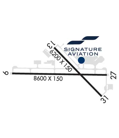
WHEN TWR CLSD ACTVT HIRL RY 09/27; MIRL RY 13/31; VASI RY 31, PAPI RYS 13 & 09 AND 27; MALSR RYS 31 & 09 AND 27 (2330-0500) AND TWY LGTS - CTAF.
Airport Storage AvailableTie Downs, Hanger
Extra Services AvailableAir Freight, Air Ambulance, Avionics, Cargo Handling, Charter, Flight Instruction, Aircraft Rental, Aircraft Sales
Wind IndicatorYES - (lighted)
Control TowerYES
CTAF Frequency118.700
Unicom Frequency122.950
Rotating Beacon ColorWG
Segmented CircleNO
Landing FeeNO

Airport Inspection Data

Airport InspectedFEDERAL - performed by FAA AIRPORTS FIELD PERSONNEL
Inspection Date09/05/2023

Airport Services

Type of Fuel AvailableGrade 100LL, JET A (freeze point -40C); -10FOR FUEL SVC AFTER HRS CALL 319-366-1925.
Airframe Repair ServiceMAJOR
Power Plant Repair ServiceMAJOR

Geographic Data

LatitudeN4153.1
LongitudeW09142.6 (ESTIMATED)
Arpt Elevation869ft (SURVEYED)
Magnetic Variation02E
6 miles SWof CEDAR RAPIDS
Traffic Pattern Altitude
Sectional ChartCHICAGO

Aircraft Data

Operations (Reported)YearlyAvg. Daily
General Aviation Transient 1147531
General Aviation Local 853923
Air Taxi 490813
Commerical 1314036
Commuter 00
Military 2381
Aircraft based on Field
General Aviation Singles 112
General Aviation Multi 4
Jet Aircraft 11
General Aviation Helicopters 1
Military Aircraft 0
Gliders 0
Ultralights 0

FAA Services

FSS on field NO
FSS tie-in FORT DODGE
FSS Phone 1-800-WX-BRIEF
Who issues Notams CID
Notam D service at airport YES
ARTCC Name CHICAGO

Federal Status

Airport CertificationAIRPORT RECEIVING SCHEDULED AIR CARRIER SERVICE FROM CARRIERS CERTIFICATED BY THE CIVIL AERONAUTICS BOARD; INDEX C LEVEL ARFF AVAILABLE UPON REQUEST WITH 48 HRS NOTICE 319-731-5722.
Aircraft Rescue & Firefighting IndexAIRPORT HAS A CERTIFICATE UNDER CFR PART 139
Airport of EntryNo
Custom Landing RightsNo
Joint Civil/MilitaryNo
Military Landing rightsYES

Federal Agreements

NATIONAL PLAN OF INTEGRATED AIRPORT SYSTEMS (NPIAS)
GRANT AGREEMENTS UNDER FAAP/ADAP/AIP
ASSURANCES PURSUANT TO TITLE VI, CIVIL RIGHTS ACT OF 1964
AGREEMENT UNDER DLAND OR DCLA HAS EXPIRED.

Remarks

BIRDS ON & INVOF ARPT.
WHEN ATCT CLSD & DURING SNOW & ICE EVENTS; ALL ARR/ DEP ACFT ANNOUNCE THEIR INTENTIONS ON CTAF 5 MINS PRIOR TO USING THE RYS. PERSONNEL & EQUIPMENT PERFORMING SNOW & ICE REMOVAL OPS WILL MONITOR CTAF.
TWY D IS NON-MOVEMENT SOUTHEAST OF ARPT ACCESS ROAD.
RY 27 IS CALM WIND RY.
TRML RAMP IS NON-MOVEMENT. CALL FOR PUSH-BACK NOT RQRD.
100LL SELF FUELING STATION LOCATED ON WEST GA APRON.
FOR CD IF UNA TO CTC ON FSS FREQ, CTC CHICAGO ARTCC AT 630-906-8921.
Airport Communications & Frequencies:
ATIS Frequencies:   Hours(local) of Operation: CONTINUOUS
124.15
CEDAR RAPIDS Tower Frequencies:   Hours(local) of operation: 0500-2330   
118.7
266.8
CEDAR RAPIDS Ground Frequencies:
121.6
Clearance Delivery Frequencies:
125.45
CTAF Frequency:
118.700
Unicom Frequency:
122.950
Remarks
  • APCH/DEP SVC PRVDD BY CHICAGO ARTCC ON FREQS 132.8/328.4 (CEDAR RAPIDS RCAG) WHEN APCH CTL CLSD.
  • CEDAR RAPIDS Primary Approach Frequencies:   Hours(local) of operation: 0500-2330   
    119.7 ;091-269
    134.05 ;270-090
    266.8
    CHICAGO ARTCC Part-time Approach Frequencies:   Hours(local) of operation: 2330-0500   
    119.05
    CEDAR RAPIDS Primary Departure Frequencies:   Hours(local) of operation: 0500-2330   
    119.7 ;091-269
    134.05 ;270-090
    266.8
    Class C Frequencies:
    119.7 ;091-269
    134.05 ;270-090
    266.8
    Runway Identifications
    Runway Identification: 09/27
    Length: 8600 ft
    Width: 150 ft
    Surface: CONCRETE
    Edge lights: High Intensity

    Treatment: GROOVED
    Weight: PCN 67 /R/B/W/T

     Runway: 09   Runway: 27
    Mag heading: 89°Mag heading: 269°
    Rwy Slope: .07% UpRwy Slope: -.07% Down
    Approach: ILSApproach: ILS/DME
    Pattern: Left TrafficPattern: Left Traffic
    Markings: PRECISION INSTRUMENTMarkings: PRECISION INSTRUMENT
    Marking Condition: GOODMarking Condition: GOOD
    Arresting Dev: Arresting Dev:
    Lat & Long: N4153.1  W09143.8Lat. & Long.: N4153.1  W09141.9
    Elev: 854.0 ft. MSLElev: 859.8 ft. MSL
    TCH: 60 ft. AGLTCH: 46 ft. AGL
    Visual Glide Path: 3.00 degreesVisual Glide Path: 3.00 degrees
    Displaced Threshold: NoDisplaced Threshold: 425 feet
    Touchdown Zone: YESTouchdown Zone: YES
    Touchdown Elev.: 856.9 feetTouchdown Elev.: 861.7 feet
    Visual Glide Slope: 4-Light PAPI on RIGHT side of RunwayVisual Glide Slope: 4-Light PAPI on LEFT side of Runway
    RVR Equipment: TOUCHDOWN-ROLLOUTRVR Equipment: TOUCHDOWN-ROLLOUT
    RVV Equipment: NORVV Equipment: NO
    Approach Lights: MALSR - 1,400 foot medium intensity approach lighting system with runway alignment indicator lightsApproach Lights: MALSR - 1,400 foot medium intensity approach lighting system with runway alignment indicator lights
    REIL: NOREIL: NO
    Centerline Lights: NOCenterline Lights: NO
    Touchdown lights: NOTouchdown lights: NO
    Runway Category: Precision Instrument RunwayRunway Category: Precision Instrument Runway
    Declared Distances: TORA:8600' TODA:8600' ASDA:8175' LDA:8175'Declared Distances: TORA:8600' TODA:8600' ASDA:8600' LDA:8175'
    Obstructions: Obstructions: RR
    Marked: Marked: NOT Marked/Lighted
    Clearance slope: 50:1Clearance slope: 39:1
    Obstruction height: Obstruction height: 14 feet AGL
    Dist. from runway: Dist. from runway: 740 feet
    Centerline offset: Centerline offset:
    Comments: Comments:
    Runway Identification: 13/31
    Length: 6200 ft
    Width: 150 ft
    Surface: CONCRETE-GOOD CONDITION
    Edge lights: Medium Intensity

    Treatment: GROOVED
    Weight: PCN 73 /R/B/W/T

     Runway: 13   Runway: 31
    Mag heading: 134°Mag heading: 314°
    Rwy Slope: -.35% DownRwy Slope: .35% Up
    Approach: Approach:
    Pattern: Left TrafficPattern: Left Traffic
    Markings: NONPRECISION INSTRUMENTMarkings: NONPRECISION INSTRUMENT
    Marking Condition: GOODMarking Condition: GOOD
    Arresting Dev: Arresting Dev:
    Lat & Long: N4153.5  W09142.9Lat. & Long.: N4152.7  W09142.0
    Elev: 869.3 ft. MSLElev: 847.6 ft. MSL
    TCH: 51 ft. AGLTCH: 50 ft. AGL
    Visual Glide Path: 3.00 degreesVisual Glide Path: 3.00 degrees
    Displaced Threshold: NoDisplaced Threshold: No
    Touchdown Zone: YESTouchdown Zone: YES
    Touchdown Elev.: 869.4 feetTouchdown Elev.: 861.0 feet
    Visual Glide Slope: 4-Light PAPI on LEFT side of RunwayVisual Glide Slope: 4-BOX VASI ON LEFT SIDE OF RUNWAY
    RVR Equipment: RVR Equipment:
    RVV Equipment: NORVV Equipment: NO
    Approach Lights: Approach Lights: MALSR - 1,400 foot medium intensity approach lighting system with runway alignment indicator lights
    REIL: YESREIL: NO
    Centerline Lights: NOCenterline Lights: NO
    Touchdown lights: NOTouchdown lights: NO
    Runway Category: Runway with a Non-precision Approach having visibility minimums greater than 3/4 mileRunway Category: D
    Declared Distances: TORA:6200' TODA:6200' ASDA:6200' LDA:6200'Declared Distances: TORA:6200' TODA:6200' ASDA:6200' LDA:6200'
    C:57/P: