
| ||||||||||||||||||||||||||||||||||||||||||||
| ||||||||||||||||||||||||||||||||||||||||||||
| Rwy | Rwy | |||||||
| 3499x77 | 3499' | 3499x77 | 3499' | |||||
| Runway ID | Single Wheel | Double Wheel | Double Tandem Wheel | Dual Double Wheel |
| 13/31 | 10,000 | N/A | N/A | N/A |
| These numbers are Advisory and are not limits. The Airport Manager should have more accurate Weight Limits | ||||
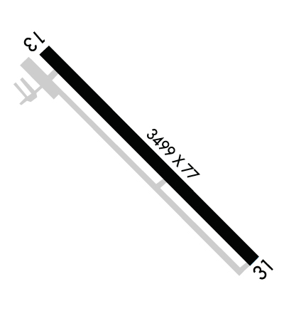 Airport Diagram might not be current. | |
| Facility Name: | HOUSTON COUNTY |
| City Name: | CALEDONIA |
| County: | HOUSTON |
| State abbrev: | MN |
| State Name: | MINNESOTA |
| Ownership: | PUBLICLY OWNED |
| Use: | OPEN TO THE PUBLIC |
| Owner's Name: | HOUSTON COUNTY |
| Address: | 304 S MARSHALL ST |
| CALEDONIA, MN 55921-1389 | |
| Owner's Phone: | 507-725-5803 |
| Manager's Name: | BRIAN POGODZINSKI |
| Address: | 1124 E WASHINGTON ST |
| CALEDONIA, MN 55921-1623 | |
| Phone: | 507-725-3925 |
| FAA Region: | GREAT LAKES |
| FAA Field Office: | DMA |

| Date | Sunrise | Sunset |
|---|---|---|
| 04/23/24 Tuesday | 6:09 | 20:00 |
| 04/24/24 Wednesday | 6:08 | 20:01 |
| 04/25/24 Thursday | 6:06 | 20:02 |
| 04/26/24 Friday | 6:05 | 20:03 |
| 04/27/24 Saturday | 6:03 | 20:05 |
| 04/28/24 Sunday | 6:02 | 20:06 |
| 04/29/24 Monday | 6:00 | 20:07 |
| 04/30/24 Tuesday | 5:59 | 20:08 |
| 05/01/24 Wednesday | 5:57 | 20:09 |
| 05/02/24 Thursday | 5:56 | 20:10 |
| 05/03/24 Friday | 5:55 | 20:12 |
| 05/04/24 Saturday | 5:53 | 20:13 |
| 05/05/24 Sunday | 5:52 | 20:14 |
| 05/06/24 Monday | 5:51 | 20:15 |
| Airport Attendance Schedule | UNATTENDED |
| Airport Status | OPERATIONAL (This Status can change at any time - please check NOTAMS) |
| Airport Lighting Schedule | MIRL RWY 13/31 PRESET LOW INTS SS-SR; TO INCR INTS & ACTVT MIRL RWY 13/31 - CTAF. |
| Airport Storage Available | Tie Downs |
| Extra Services Available | NONE |
| Wind Indicator | YES - (lighted) |
| Control Tower | NO |
| CTAF Frequency | 122.900 |
| Unicom Frequency | |
| Rotating Beacon Color | WG |
| Segmented Circle | NO |
| Landing Fee | NO |
| Airport Inspected | STATE - performed by STATE AERONAUTICAL PERSONNEL |
| Inspection Date | 09/10/2021 |
| Type of Fuel Available | Grade 100LL; -1024 HR CREDIT CARD SVC AVBL. |
| Airframe Repair Service | NONE |
| Power Plant Repair Service | NONE |
| Latitude | N4335.8 |
| Longitude | W09130.2 (ESTIMATED) |
| Arpt Elevation | 1179ft (SURVEYED) |
| Magnetic Variation | 01E |
| 3 miles S | of CALEDONIA |
| Traffic Pattern Altitude | |
| Sectional Chart | CHICAGO |
| Operations (Reported) | Yearly | Avg. Daily |
|---|---|---|
| General Aviation Transient | 1500 | 4 |
| General Aviation Local | 2000 | 5 |
| Air Taxi | 0 | 0 |
| Commerical | 0 | 0 |
| Commuter | 0 | 0 |
| Military | 0 | 0 |
| Aircraft based on Field | |
|---|---|
| General Aviation Singles | 13 |
| General Aviation Multi | 0 |
| Jet Aircraft | 0 |
| General Aviation Helicopters | 0 |
| Military Aircraft | 0 |
| Gliders | 0 |
| Ultralights | 0 |
| FSS on field | NO |
| FSS tie-in | PRINCETON |
| FSS Phone | 1-800-WX-BRIEF |
| Who issues Notams | PNM |
| Notam D service at airport | YES |
| ARTCC Name | MINNEAPOLIS |
| Airport Certification | |
| Aircraft Rescue & Firefighting Index | None |
| Airport of Entry | No |
| Custom Landing Rights | No |
| Joint Civil/Military | No |
| Military Landing rights | YES |
| NATIONAL PLAN OF INTEGRATED AIRPORT SYSTEMS (NPIAS) |
| ASSURANCES PURSUANT TO TITLE VI, CIVIL RIGHTS ACT OF 1964 |
| GRANT AGREEMENT HAS EXPIRED; HOWEVER, AGREEMENT REMAINS IN EFFECT FOR THIS FACILITY AS LONG AS IT IS PUBLIC USE. |
| THIS AIRPORT HAS BEEN SURVEYED BY THE NATIONAL GEODETIC SURVEY. |
| TURF TWY 25 FT WIDE |
| TURF TWY UNEVEN |
| FOR CD CTC MINNEAPOLIS ARTCC AT 651-463-5588. |
Airport Communications & Frequencies:
| |||||||
| Runway: 13 | Runway: 31 | ||
| Mag heading: | 134° | Mag heading: | 314° |
| Rwy Slope: | .11% Up | Rwy Slope: | -.11% Down |
| Approach: | Approach: | ||
| Pattern: | Left Traffic | Pattern: | Left Traffic |
| Markings: | NONPRECISION INSTRUMENT | Markings: | NONPRECISION INSTRUMENT |
| Marking Condition: | FAIR | Marking Condition: | GOOD |
| Arresting Dev: | Arresting Dev: | ||
| Lat & Long: | N4336.0 W09130.5 | Lat. & Long.: | N4335.6 W09130.0 |
| Elev: | 1175.0 ft. MSL | Elev: | 1179.0 ft. MSL |
| TCH: | TCH: | ||
| Visual Glide Path: | Visual Glide Path: | ||
| Displaced Threshold: | No | Displaced Threshold: | No |
| Touchdown Zone: | NO | Touchdown Zone: | YES |
| Touchdown Elev.: | Touchdown Elev.: | 1179.0 feet | |
| Visual Glide Slope: | Visual Glide Slope: | ||
| RVR Equipment: | RVR Equipment: | ||
| RVV Equipment: | NO | RVV Equipment: | NO |
| Approach Lights: | Approach Lights: | ||
| REIL: | NO | REIL: | NO |
| Centerline Lights: | NO | Centerline Lights: | NO |
| Touchdown lights: | NO | Touchdown lights: | NO |
| Runway Category: | Runway with a Visual Approach | Runway Category: | Runway with a Visual Approach |
| Declared Distances: | Declared Distances: |