Current Weather/Notams (Metars, TAFs, Notams, NWS Forecast, PIREPS, and nearby weather)
Customs Information Send updates to Support@FltPlan.com
Customs Not Available
Database effective 05/16/2024
Airport Diagram might not be current. Facility Name: CHILLICOTHE MUNI City Name: CHILLICOTHE County: LIVINGSTON State abbrev: MO State Name: MISSOURI Ownership: PUBLICLY OWNED Use: OPEN TO THE PUBLIC Owner's Name: CITY OF CHILLICOTHE Address: 715 WASHINGTON CHILLICOTHE, MO 64601 Owner's Phone: 660-646-1877 Manager's Name: TOBY CALIVERE Address: 13844 LIV 253 CHILLICOTHE, MO 64601 Phone: 660-646-5270 FAA Region: CENTRAL FAA Field Office: NONE
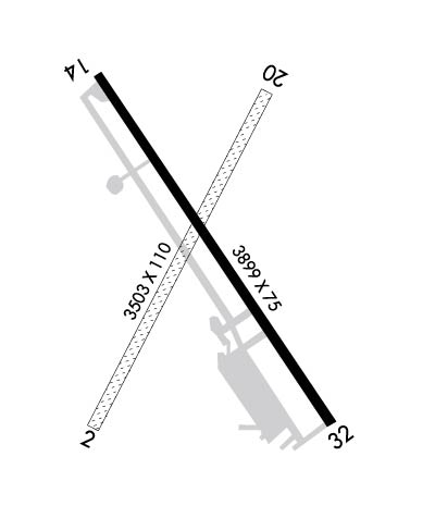
Runway Identifications Help
Runway Identification: 02/20 Length: 3503 ftWidth: 110 ftSurface: GRASS-GOOD CONDITIONEdge lights: Treatment: NONE Runway: 02 Runway: 20 Mag heading: 23° Mag heading: 203° Rwy Slope: .44% Up Rwy Slope: -.44% Down Approach: Approach: Pattern: Left Traffic Pattern: Left Traffic Markings: Markings: Marking Condition: GOOD; RWY 02/20 MARKED WITH LARGE YELLOW CONES. DSPLCD THRS MARKED WITH 3 LARGE YELLOW CONES ON EACH SIDE OF RWY. Marking Condition: Arresting Dev: Arresting Dev: Lat & Long: N3946.7 W09330.0 Lat. & Long.: N3947.2 W09329.6 Elev: 756.9 ft. MSL Elev: 772.4 ft. MSL TCH: TCH: Visual Glide Path: Visual Glide Path: Displaced Threshold: 206 feet Displaced Threshold: 389 feet Touchdown Zone: YES Touchdown Zone: YES Touchdown Elev.: 778.4 feet Touchdown Elev.: 778.4 feet Visual Glide Slope: Visual Glide Slope: RVR Equipment: RVR Equipment: RVV Equipment: NO RVV Equipment: NO Approach Lights: Approach Lights: REIL: NO REIL: NO Centerline Lights: NO Centerline Lights: NO Touchdown lights: NO Touchdown lights: NO Runway Category: Runway with a Visual Approach Runway Category: Runway with a Visual Approach Declared Distances: Declared Distances: Obstructions: Obstructions: TREE Marked: Marked: NOT Marked/Lighted Clearance slope: 20:1; RWY 20 - 23:1 BASED ON DSPLCD THR Clearance slope: 13:1 Obstruction height: Obstruction height: 39 feet AGL Dist. from runway: Dist. from runway: 544 feet Centerline offset: Centerline offset: 130 feet left of centerline Comments: Comments:
Runway Identification: 14/32 Length: 3899 ftWidth: 75 ftSurface: CONCRETEEdge lights: Medium Intensity Treatment: NONEWeight: PCN 11 /R/C/W/T Runway: 14 Runway: 32 Mag heading: 140° Mag heading: 320° Rwy Slope: -.50% Down Rwy Slope: .50% Up Approach: Approach: Pattern: Left Traffic Pattern: Left Traffic Markings: NONPRECISION INSTRUMENT Markings: NONPRECISION INSTRUMENT Marking Condition: GOOD Marking Condition: GOOD Arresting Dev: Arresting Dev: Lat & Long: N3947.2 W09330.0 Lat. & Long.: N3946.7 W09329.5 Elev: 782.9 ft. MSL Elev: 763.5 ft. MSL TCH: 40 ft. AGL TCH: 44 ft. AGL Visual Glide Path: 3.00 degrees Visual Glide Path: 3.50 degrees Displaced Threshold: No Displaced Threshold: No Touchdown Zone: YES Touchdown Zone: YES Touchdown Elev.: 782.9 feet Touchdown Elev.: 782.1 feet Visual Glide Slope: 4-Light PAPI on LEFT side of Runway Visual Glide Slope: 4-Light PAPI on RIGHT side of Runway RVR Equipment: RVR Equipment: RVV Equipment: NO RVV Equipment: NO Approach Lights: Approach Lights: REIL: YES REIL: YES Centerline Lights: NO Centerline Lights: NO Touchdown lights: NO Touchdown lights: NO Runway Category: Runway with a Non-precision Approach Runway Category: Runway with a Non-precision Approach Declared Distances: Declared Distances: