
| ||||||||||||||||||||||||||||||||||||||||||||
| ||||||||||||||||||||||||||||||||||||||||||||
| ||||||||||||||||||||||||||||||||||||||||||||
| FBOs at nearby airports who want your business: | |||||||||||||||||
| |||||||||||||||||
| Rwy | Rwy | |||||||
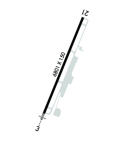
| 6801x150 | 6801' | 111.70 - 030° | 6801x150 | 6801' | ||||
| Runway ID | Single Wheel | Double Wheel | Double Tandem Wheel | Dual Double Wheel |
| 03/21 | 120,000 | 228,000 | 368,000 | N/A |
| These numbers are Advisory and are not limits. The Airport Manager should have more accurate Weight Limits | ||||
 Airport Diagram might not be current. | |
| Facility Name: | CHARLOTTESVILLE-ALBEMARLE |
| City Name: | CHARLOTTESVILLE |
| County: | ALBEMARLE |
| State abbrev: | VA |
| State Name: | VIRGINIA |
| Ownership: | PUBLICLY OWNED |
| Use: | OPEN TO THE PUBLIC |
| Owner's Name: | CHRLTSVL-ALBMRL ARPT AUTH |
| Address: | 100 BOWEN LOOP, SUITE 200 |
| CHARLOTTESVILLE, VA 22911 | |
| Owner's Phone: | 434-973-8341 |
| Manager's Name: | MELINDA CRAWFORD; X104. |
| Address: | 100 BOWEN LOOP, SUITE 200 |
| CHARLOTTESVILLE, VA 22911 | |
| Phone: | 434-973-8342 |
| FAA Region: | EASTERN |
| FAA Field Office: | DCA |
| Date | Sunrise | Sunset |
|---|---|---|
| 04/24/24 Wednesday | 6:25 | 19:59 |
| 04/25/24 Thursday | 6:24 | 20:00 |
| 04/26/24 Friday | 6:23 | 20:01 |
| 04/27/24 Saturday | 6:21 | 20:02 |
| 04/28/24 Sunday | 6:20 | 20:03 |
| 04/29/24 Monday | 6:19 | 20:04 |
| 04/30/24 Tuesday | 6:18 | 20:05 |
| 05/01/24 Wednesday | 6:17 | 20:06 |
| 05/02/24 Thursday | 6:15 | 20:07 |
| 05/03/24 Friday | 6:14 | 20:07 |
| 05/04/24 Saturday | 6:13 | 20:08 |
| 05/05/24 Sunday | 6:12 | 20:09 |
| 05/06/24 Monday | 6:11 | 20:10 |
| 05/07/24 Tuesday | 6:10 | 20:11 |
| Airport Attendance Schedule | CONTINUOUS |
| Airport Status | OPERATIONAL (This Status can change at any time - please check NOTAMS) |
| Airport Lighting Schedule | WHEN ATCT CLSD HIRL RWY 03/21, & TWY LIGHTS PRESET LOW INTST. TO ACTVT & INCREASE INTST MALSR RWY 03; REIL RWY 21; HIRL RWY 03/21 & TWY LIGHTS - CTAF. |
| Airport Storage Available | Tie Downs, Hanger |
| Extra Services Available | Charter, Flight Instruction, Aircraft Rental |
| Wind Indicator | YES - (lighted) |
| Control Tower | YES |
| CTAF Frequency | 124.500 |
| Unicom Frequency | 122.950 |
| Rotating Beacon Color | WG |
| Segmented Circle | YES |
| Landing Fee | YES; LNDG FEE ONLY FOR ACFT OVER 7000 LBS. |
| Airport Inspected | FEDERAL - performed by FAA AIRPORTS FIELD PERSONNEL |
| Inspection Date | 04/19/2023 |
| Type of Fuel Available | Grade 100LL, JET A (freeze point -40C) |
| Airframe Repair Service | MAJOR |
| Power Plant Repair Service | MAJOR |
| Latitude | N3808.4 |
| Longitude | W07827.1 (ESTIMATED) |
| Arpt Elevation | 640ft (SURVEYED) |
| Magnetic Variation | 08W |
| 7 miles N | of CHARLOTTESVILLE |
| Traffic Pattern Altitude | |
| Sectional Chart | WASHINGTON |
| Operations (Reported) | Yearly | Avg. Daily |
|---|---|---|
| General Aviation Transient | 40627 | 111 |
| General Aviation Local | 37154 | 102 |
| Air Taxi | 25162 | 69 |
| Commerical | 5140 | 14 |
| Commuter | 0 | 0 |
| Military | 14070 | 39 |
| Aircraft based on Field | |
|---|---|
| General Aviation Singles | 48 |
| General Aviation Multi | 4 |
| Jet Aircraft | 8 |
| General Aviation Helicopters | 2 |
| Military Aircraft | 0 |
| Gliders | 0 |
| Ultralights | 0 |
| FSS on field | NO |
| FSS tie-in | LEESBURG |
| FSS Phone | 1-800-WX-BRIEF |
| Who issues Notams | CHO |
| Notam D service at airport | YES |
| ARTCC Name | WASHINGTON |
| Airport Certification | AIRPORT RECEIVING SCHEDULED AIR CARRIER SERVICE FROM CARRIERS CERTIFICATED BY THE CIVIL AERONAUTICS BOARD; PPR 8 HRS FOR UNSKED ACR OPNS WITH MORE THAN 9 PASSENGER SEATS BTWN 0400-1100Z; CALL APRT MGR 434-981-4152. |
| Aircraft Rescue & Firefighting Index | AIRPORT HAS A CERTIFICATE UNDER CFR PART 139 |
| Airport of Entry | No |
| Custom Landing Rights | No |
| Joint Civil/Military | No |
| Military Landing rights | YES |
| NATIONAL PLAN OF INTEGRATED AIRPORT SYSTEMS (NPIAS) |
| GRANT AGREEMENTS UNDER FAAP/ADAP/AIP |
| ASSURANCES PURSUANT TO TITLE VI, CIVIL RIGHTS ACT OF 1964 |
| COMPLIANCE WITH ACCESSIBILITY TO THE HANDICAPPED |
| DEER & BIRDS ON & INVOF ARPT. |
| FOR CD WHEN ATCT IS CLSD CTC POTOMAC APCH AT 866-640-4124. |
| FOR ACFT SVCS CTC 126.925. |
Airport Communications & Frequencies:
| ||||||||||||||||||||||||||||||||
| Runway: 03 | Runway: 21 | ||
| Mag heading: | 30° | Mag heading: | 210° |
| Rwy Slope: | -.32% Down | Rwy Slope: | .32% Up |
| Approach: | ILS/DME | Approach: | |
| Pattern: | Left Traffic | Pattern: | Left Traffic |
| Markings: | PRECISION INSTRUMENT | Markings: | NONPRECISION INSTRUMENT |
| Marking Condition: | GOOD | Marking Condition: | GOOD |
| Arresting Dev: | Arresting Dev: | ||
| Lat & Long: | N3807.9 W07827.4 | Lat. & Long.: | N3808.9 W07826.9 |
| Elev: | 640.1 ft. MSL | Elev: | 618.3 ft. MSL |
| TCH: | 53 ft. AGL | TCH: | 50 ft. AGL |
| Visual Glide Path: | 3.00 degrees | Visual Glide Path: | 3.00 degrees |
| Displaced Threshold: | No | Displaced Threshold: | No |
| Touchdown Zone: | YES | Touchdown Zone: | YES |
| Touchdown Elev.: | 640.1 feet | Touchdown Elev.: | 626.0 feet |
| Visual Glide Slope: | 4-Light PAPI on LEFT side of Runway | Visual Glide Slope: | 4-Light PAPI on RIGHT side of Runway; UNUSBL BYD 6.5 DEG L OF RCL. |
| RVR Equipment: | RVR Equipment: | ||
| RVV Equipment: | NO | RVV Equipment: | NO |
| Approach Lights: | MALSR - 1,400 foot medium intensity approach lighting system with runway alignment indicator lights | Approach Lights: | |
| REIL: | NO | REIL: | YES |
| Centerline Lights: | NO | Centerline Lights: | NO |
| Touchdown lights: | NO | Touchdown lights: | NO |
| Runway Category: | Precision Instrument Runway | Runway Category: | Runway with a Non-precision Approach having visibility minimums greater than 3/4 mile |
| Declared Distances: | TORA:6801' TODA:6801' ASDA:6801' LDA:6801' | Declared Distances: | TORA:6801' TODA:6801' ASDA:6801' LDA:6801' |
| Comments: | Comments: | +7 FT OBST LGTD EQPT BOX RACK 78 FT FM AER, 250 FT L. |