Current Weather/Notams (Metars, TAFs, Notams, NWS Forecast, PIREPS, and nearby weather)
Customs Information Send updates to Support@FltPlan.com
Customs Not Available
Database effective 04/18/2024
Airport Diagram might not be current. Facility Name: CHICKASHA MUNI City Name: CHICKASHA County: GRADY State abbrev: OK State Name: OKLAHOMA Ownership: PUBLICLY OWNED Use: OPEN TO THE PUBLIC Owner's Name: CITY OF CHICKASHA Address: CITY HALL 117 N 4TH STREET CHICKASHA, OK 73018 Owner's Phone: (405) 222-6020 Manager's Name: KEITH JOHNSON; CLINT FERGUSON 405-320-0274. Address: CITY HALL 117 N 4TH STREET CHICKASHA, OK 73018 Phone: (405) 222-6045 FAA Region: SOUTHWEST FAA Field Office: AOK
Runway Identifications Help
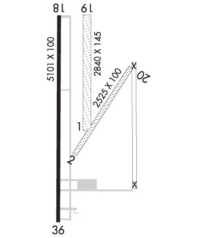
Runway Identification: 01/19 Length: 2232 ftWidth: 100 ftSurface: GRASS-FAIR CONDITIONEdge lights: Treatment: NONE Runway: 01 Runway: 19 Mag heading: 356° Mag heading: 176° Rwy Slope: .32% Up Rwy Slope: -.32% Down Approach: Approach: Pattern: Left Traffic Pattern: Left Traffic Markings: NONSTANDARD Markings: NONSTANDARD Marking Condition: FAIR Marking Condition: FAIR Arresting Dev: Arresting Dev: Lat & Long: N3505.7 W09758.0 Lat. & Long.: N3506.1 W09758.0 Elev: 1137.2 ft. MSL Elev: 1144.4 ft. MSL TCH: TCH: Visual Glide Path: Visual Glide Path: Displaced Threshold: No Displaced Threshold: No Touchdown Zone: YES Touchdown Zone: YES Touchdown Elev.: 1144.4 feet Touchdown Elev.: 1144.4 feet Visual Glide Slope: Visual Glide Slope: RVR Equipment: RVR Equipment: RVV Equipment: NO RVV Equipment: NO Approach Lights: Approach Lights: REIL: NO REIL: NO Centerline Lights: NO Centerline Lights: NO Touchdown lights: NO Touchdown lights: NO Runway Category: Runway Category: Declared Distances: Declared Distances:
Runway Identification: 02/20 Length: 2404 ftWidth: 100 ftSurface: GRASS-FAIR CONDITIONEdge lights: Treatment: NONE Runway: 02 Runway: 20 Mag heading: 29° Mag heading: 209° Rwy Slope: .28% Up Rwy Slope: -.28% Down Approach: Approach: Pattern: Left Traffic Pattern: Left Traffic Markings: NONSTANDARD Markings: NONSTANDARD Marking Condition: FAIR Marking Condition: FAIR Arresting Dev: Arresting Dev: Lat & Long: N3505.7 W09758.0 Lat. & Long.: N3506.0 W09757.8 Elev: 1136.0 ft. MSL Elev: 1142.7 ft. MSL TCH: TCH: Visual Glide Path: Visual Glide Path: Displaced Threshold: No Displaced Threshold: No Touchdown Zone: YES Touchdown Zone: YES Touchdown Elev.: 1142.7 feet Touchdown Elev.: 1142.7 feet Visual Glide Slope: Visual Glide Slope: RVR Equipment: RVR Equipment: RVV Equipment: NO RVV Equipment: NO Approach Lights: Approach Lights: REIL: NO REIL: NO Centerline Lights: NO Centerline Lights: NO Touchdown lights: NO Touchdown lights: NO Runway Category: Runway Category: Declared Distances: Declared Distances: Obstructions: 35 FT PWR LN 631 FT FM RWY END BOTH SIDES 19:1 CLNC SLOPE NL. Obstructions: TREE Marked: NOT Marked/Lighted Marked: NOT Marked/Lighted Clearance slope: Clearance slope: 18:1 Obstruction height: Obstruction height: 49 feet AGL Dist. from runway: Dist. from runway: 914 feet Centerline offset: Centerline offset: 145 feet left of centerline Comments: Comments:
Runway Identification: 18/36 Length: 5101 ftWidth: 100 ftSurface: CONCRETE-GOOD CONDITIONEdge lights: Medium Intensity Treatment: NONE Runway: 18 Runway: 36 Mag heading: 176° Mag heading: 356° Rwy Slope: -.40% Down Rwy Slope: .40% Up Approach: Approach: Pattern: Left Traffic Pattern: Left Traffic Markings: NONPRECISION INSTRUMENT Markings: NONPRECISION INSTRUMENT Marking Condition: FAIR Marking Condition: FAIR Arresting Dev: Arresting Dev: Lat & Long: N3506.2 W09758.2 Lat. & Long.: N3505.4 W09758.2 Elev: 1150.3 ft. MSL Elev: 1129.8 ft. MSL TCH: 40 ft. AGL TCH: 40 ft. AGL Visual Glide Path: 3.00 degrees Visual Glide Path: 3.00 degrees Displaced Threshold: No Displaced Threshold: No Touchdown Zone: YES Touchdown Zone: YES Touchdown Elev.: 1151.5 feet Touchdown Elev.: 1140.2 feet Visual Glide Slope: 4-Light PAPI on LEFT side of Runway Visual Glide Slope: 4-Light PAPI on LEFT side of Runway RVR Equipment: RVR Equipment: RVV Equipment: NO RVV Equipment: NO Approach Lights: Approach Lights: REIL: NO REIL: NO Centerline Lights: NO Centerline Lights: NO Touchdown lights: NO Touchdown lights: NO Runway Category: D Runway Category: Runway with a Non-precision Approach having visibility minimums greater than 3/4 mile Declared Distances: Declared Distances: Obstructions: Obstructions: TREES Marked: Marked: NOT Marked/Lighted Clearance slope: 34:1 Clearance slope: 17:1 Obstruction height: Obstruction height: 43 feet AGL Dist. from runway: Dist. from runway: 944 feet Centerline offset: Centerline offset: 276 feet right of centerline Comments: Comments: