Click here for more info on on SMS!

KCGI

CAPE GIRARDEAU RGNL
CAPE GIRARDEAU
MO
Time Zone: Central
Lat: N 3713.5
Long: W 08934.2
Elev: 342
Var: +02
Longest Runway: 6500
AWOS: 120.55
Ground: 124.7
Tower: 125.52

FBO & Flight Services info for KCGI

FBOs: Update your Fuel Prices

CAPE AVIATIONPh: 573-335-6632 Fax: 573-335-1973 Freq: 122.95
Service
Jet
100LL
SAF
MoGas
Fuel Avail: JET A INCLUDES PRIST
Full5.115.99    Last Update: 04/17/2024 09:49

Self  5.44    
 Address: AIRPORT RD   CAPE GIRARDEAU, MO 63702
ASOSPh: 573-335-3811
-
Freq: 120.55  
If you are an FBO, call 1-203-262-1700 to update your info or email: FltPlan.Advertising@garmin.com
Advertise your FBO on FltPlan.com

Runway & Approach Info for KCGI
Rwy
Length
Land Dist**
Approach*
  Rwy
Length
Land Dist**
Approach*
02
3997x100  3997'          
 
  
20
  3997x100  3997'          
 
10
6500x150  6500'          
ILS/DME
 109.50 - 107°  
  
28
  6500x150  6500'          
 
 * only ILS, LOC, LDA, and SDF approaches to a specific runway are shown
** For any Declared Landing Distance Available, please see A/FD or Approach plates
Runway Weight Capability (lbs.) Help
Runway IDSingle WheelDouble WheelDouble Tandem WheelDual Double Wheel
02/2045,00060,000100,000N/A
10/2893,000125,000215,000N/A
These numbers are Advisory and are not limits.   The Airport Manager should have more accurate Weight Limits
Approach Charts
Approaches    
Current Weather/Notams
Customs Information Send updates to Support@FltPlan.com
Customs Not Available
Database effective 04/18/2024
Airport Diagram of KCGI
Airport Diagram might not be current.

Facility Name: CAPE GIRARDEAU RGNL
City Name: CAPE GIRARDEAU
County: SCOTT
State abbrev: MO
State Name: MISSOURI
   
Ownership: PUBLICLY OWNED
Use: OPEN TO THE PUBLIC
Owner's Name: CITY OF CAPE GIRARDEAU
Address: CITY HALL, 401 INDEPENDENCE
 CAPE GIRARDEAU, MO 63701
Owner's Phone: 573-334-1212
  
Manager's Name: MS. KATRINA D. AMOS
Address: PO BOX 617
 CAPE GIRARDEAU, MO 63702
Phone: 573-334-6230
   
FAA Region: CENTRAL
FAA Field Office: NONE
Looking northeast on a hazy evening. Brandon, 2022


Click here for full scale & interactive Sectional view of KCGI


Sunrise / Sunset times for CAPE GIRARDEAU RGNL

DateSunriseSunset
04/18/24 Thursday6:1919:37
04/19/24 Friday6:1719:38
04/20/24 Saturday6:1619:39
04/21/24 Sunday6:1519:39
04/22/24 Monday6:1319:40
04/23/24 Tuesday6:1219:41
04/24/24 Wednesday6:1119:42
04/25/24 Thursday6:1019:43
04/26/24 Friday6:0919:44
04/27/24 Saturday6:0719:45
04/28/24 Sunday6:0619:46
04/29/24 Monday6:0519:47
04/30/24 Tuesday6:0419:48
05/01/24 Wednesday6:0319:48

Airport Facilities

Airport Attendance ScheduleMON-FRI 0600-1900, SAT-SUN 0600-1800
Airport Status OPERATIONAL (This Status can change at any time - please check NOTAMS)
Airport Lighting ScheduleACTVT MALSR RWY 10; ODALS RWY 28; HIRL RWY 10/28; MIRL RWY 02/20 - CTAF.
Airport Storage AvailableTie Downs, Hanger
Extra Services AvailableAir Freight, Avionics, Charter, Flight Instruction, Aircraft Rental, Aircraft Sales
Wind IndicatorYES - (lighted)
Control TowerYES
CTAF Frequency125.525
Unicom Frequency122.950
Rotating Beacon ColorWG
Segmented CircleNO
Landing FeeNO

Airport Inspection Data

Airport InspectedFEDERAL - performed by FAA AIRPORTS FIELD PERSONNEL
Inspection Date01/17/2024

Airport Services

Type of Fuel AvailableGrade 100LL, JET A (freeze point -40C)
Airframe Repair ServiceMAJOR
Power Plant Repair ServiceMAJOR

Geographic Data

LatitudeN3713.5
LongitudeW08934.2 (ESTIMATED)
Arpt Elevation341ft (SURVEYED)
Magnetic Variation02W
5 miles SWof CAPE GIRARDEAU
Traffic Pattern Altitude
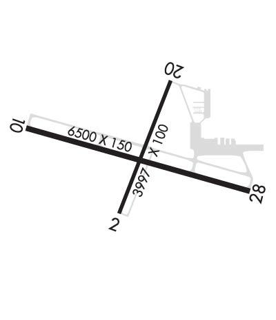
Sectional ChartST LOUIS

Aircraft Data

Operations (Reported)YearlyAvg. Daily
General Aviation Transient 1792649
General Aviation Local 2080857
Air Taxi 12834
Commerical 00
Commuter 00
Military 3321
Aircraft based on Field
General Aviation Singles 55
General Aviation Multi 6
Jet Aircraft 5
General Aviation Helicopters 10
Military Aircraft 0
Gliders 0
Ultralights 0

FAA Services

FSS on field NO
FSS tie-in SAINT LOUIS
FSS Phone 1-800-WX-BRIEF
Who issues Notams CGI
Notam D service at airport YES
ARTCC Name MEMPHIS

Federal Status

Airport CertificationAIRPORT RECEIVING SCHEDULED AIR CARRIER SERVICE FROM CARRIERS CERTIFICATED BY THE CIVIL AERONAUTICS BOARD; RWY 02/20 NOT AVBL FOR SCHEDULED ACR OPNS WITH MORE THAN 9 PSGR SEATS OR UNSCHEDULED ACR AT LEAST 31 PSGR SEATS
Aircraft Rescue & Firefighting IndexAIRPORT HAS A CERTIFICATE UNDER CFR PART 139
Airport of EntryNo
Custom Landing RightsNo
Joint Civil/MilitaryNo
Military Landing rightsYES

Federal Agreements

NATIONAL PLAN OF INTEGRATED AIRPORT SYSTEMS (NPIAS)
GRANT AGREEMENTS UNDER FAAP/ADAP/AIP
SURPLUS PROPERTY AGREEMENT UNDER REGULATION 16-WAA
ASSURANCES PURSUANT TO TITLE VI, CIVIL RIGHTS ACT OF 1964

Remarks

(E110) STANDBY GEN FOR FAA FAC ONLY
NORTHERN 100 FT TWY 'C' NOT VISIBLE FM CONTROL TOWER.
FOR CD CTC MEMPHIS ARTCC AT 901-368-8453/8449.
Airport Communications & Frequencies:
CAPE GIRARDEAU Tower Frequencies:   Hours(local) of operation: 0700-1700   
125.525
CAPE GIRARDEAU Ground Frequencies:
124.7
CTAF Frequency:
125.525
Unicom Frequency:
122.950
Remarks
  • APCH/DEP SVC PRVDD BY MEMPHIS ARTCC ON FREQS 133.65/292.15 (PADUCAH RCAG).
  • ATCT OPERATED BY CITY OF CAPE GIRARDEAU.
  • Runway Identifications
    Runway Identification: 02/20
    Length: 3997 ft
    Width: 100 ft
    Surface: CONCRETE ASPHALT-FAIR CONDITION
    Edge lights: Medium Intensity

    Treatment: NONE
    Weight: PCN 16 /R/D/W/T

     Runway: 02   Runway: 20
    Mag heading: 23°Mag heading: 203°
    Rwy Slope: -.15% DownRwy Slope: .15% Up
    Approach: Approach:
    Pattern: Left TrafficPattern: Left Traffic
    Markings: NONPRECISION INSTRUMENTMarkings: NONPRECISION INSTRUMENT
    Marking Condition: GOODMarking Condition: GOOD
    Arresting Dev: Arresting Dev:
    Lat & Long: N3713.2  W08934.4Lat. & Long.: N3713.9  W08934.1
    Elev: 341.5 ft. MSLElev: 335.7 ft. MSL
    TCH: 50 ft. AGLTCH: 44 ft. AGL
    Visual Glide Path: 4.00 degreesVisual Glide Path: 3.00 degrees
    Displaced Threshold: NoDisplaced Threshold: No
    Touchdown Zone: YESTouchdown Zone: YES
    Touchdown Elev.: 341.5 feetTouchdown Elev.: 338.5 feet
    Visual Glide Slope: 4-BOX VASI ON LEFT SIDE OF RUNWAYVisual Glide Slope: 4-BOX VASI ON LEFT SIDE OF RUNWAY
    RVR Equipment: RVR Equipment:
    RVV Equipment: NORVV Equipment: NO
    Approach Lights: Approach Lights:
    REIL: NOREIL: NO
    Centerline Lights: NOCenterline Lights: NO
    Touchdown lights: NOTouchdown lights: NO
    Runway Category: Runway with a Non-precision Approach having visibility minimums greater than 3/4 mileRunway Category: Runway with a Non-precision Approach having visibility minimums greater than 3/4 mile
    Declared Distances: TORA:3997' TODA:3997' ASDA:3997' LDA:3997'Declared Distances: TORA:3997' TODA:3997' ASDA:3997' LDA:3997'
    Obstructions: TREEObstructions:
    Marked: NOT Marked/LightedMarked:
    Clearance slope: 18:1Clearance slope: 50:1
    Obstruction height: 70 feet AGLObstruction height:
    Dist. from runway: 1500 feetDist. from runway:
    Centerline offset: 450 left of centerlineCenterline offset:
    Comments: Comments:
    Runway Identification: 10/28
    Length: 6500 ft
    Width: 150 ft
    Surface: CONCRETE-GOOD CONDITION
    Edge lights: High Intensity

    Treatment: GROOVED
    Weight: PCN 30 /R/D/W/T

     Runway: 10   Runway: 28
    Mag heading: 108°Mag heading: 288°
    Rwy Slope: .06% UpRwy Slope: -.06% Down
    Approach: ILS/DMEApproach:
    Pattern: Left TrafficPattern: Left Traffic
    Markings: PRECISION INSTRUMENTMarkings: NONPRECISION INSTRUMENT
    Marking Condition: GOODMarking Condition: GOOD
    Arresting Dev: Arresting Dev:
    Lat & Long: N3713.6  W08934.9Lat. & Long.: N3713.4  W08933.6
    Elev: 336.9 ft. MSLElev: 340.6 ft. MSL
    TCH: TCH: 38 ft. AGL
    Visual Glide Path: Visual Glide Path: 3.00 degrees
    Displaced Threshold: NoDisplaced Threshold: No
    Touchdown Zone: YESTouchdown Zone: YES
    Touchdown Elev.: 337.1 feetTouchdown Elev.: 340.8 feet
    Visual Glide Slope: Visual Glide Slope: 2-Box VASI on LEFT side of Runway
    RVR Equipment: TOUCHDOWNRVR Equipment: ROLLOUT
    RVV Equipment: NORVV Equipment: NO
    Approach Lights: MALSR - 1,400 foot medium intensity approach lighting system with runway alignment indicator lightsApproach Lights: ODALS - omnidirectional approach lighting system
    REIL: NOREIL: NO
    Centerline Lights: NOCenterline Lights: NO
    Touchdown lights: NOTouchdown lights: NO
    Runway Category: Precision Instrument RunwayRunway Category: D
    Declared Distances: TORA:6500' TODA:6500' ASDA:6500' LDA:6500'Declared Distances: TORA:6500' TODA:6500' ASDA:6500' LDA:6500'
    Obstructions: Obstructions: TREE
    Marked: Marked: NOT Marked/Lighted
    Clearance slope: 50:1Clearance slope: 33:1
    Obstruction height: Obstruction height: 160 feet AGL
    Dist. from runway: Dist. from runway: 5600 feet
    Centerline offset: Centerline offset: 1100 feet right of centerline
    Comments: Comments:
    C:22/P: