Current Weather/Notams (Metars, TAFs, Notams, NWS Forecast, PIREPS, and nearby weather)
Customs Information Send updates to Support@FltPlan.com
Customs Not Available
Database effective 05/16/2024
Airport Diagram might not be current. Facility Name: COFFEYVILLE MUNI City Name: COFFEYVILLE County: MONTGOMERY State abbrev: KS State Name: KANSAS Ownership: PUBLICLY OWNED Use: OPEN TO THE PUBLIC Owner's Name: CITY OF COFFEYVILLE Address: CITY HALL COFFEYVILLE, KS 67337 Owner's Phone: 620-251-4310 Manager's Name: JARROD POWERS Address: BOX 1629 COFFEYVILLE, KS 67337 Phone: (620) 252-8027 FAA Region: CENTRAL FAA Field Office: NONE
Runway Identifications Help
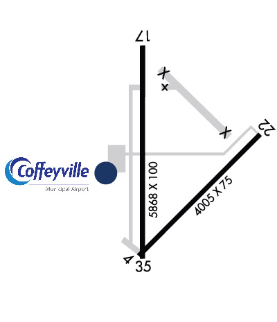
Runway Identification: 04/22 Length: 4005 ftWidth: 75 ftSurface: ASPHALT-FAIR CONDITIONEdge lights: Treatment: NONE Runway: 04 Runway: 22 Mag heading: 40° Mag heading: 220° Rwy Slope: .17% Up Rwy Slope: -.17% Down Approach: Approach: Pattern: Left Traffic Pattern: Left Traffic Markings: BASIC Markings: BASIC Marking Condition: POOR; RWY MARKINGS ARE FADED. Marking Condition: POOR; RWY MARKINGS ARE FADED. Arresting Dev: Arresting Dev: Lat & Long: N3705.3 W09534.4 Lat. & Long.: N3705.8 W09533.8 Elev: 745.9 ft. MSL Elev: 752.9 ft. MSL TCH: TCH: Visual Glide Path: Visual Glide Path: Displaced Threshold: No Displaced Threshold: No Touchdown Zone: YES Touchdown Zone: YES Touchdown Elev.: 754.4 feet Touchdown Elev.: 754.4 feet Visual Glide Slope: Visual Glide Slope: RVR Equipment: RVR Equipment: RVV Equipment: NO RVV Equipment: NO Approach Lights: Approach Lights: REIL: NO REIL: NO Centerline Lights: NO Centerline Lights: NO Touchdown lights: NO Touchdown lights: NO Runway Category: Runway with a Visual Approach Runway Category: Runway with a Visual Approach Declared Distances: Declared Distances: Obstructions: TREE Obstructions: TREE Marked: NOT Marked/Lighted Marked: NOT Marked/Lighted Clearance slope: 35:1 Clearance slope: 40:1 Obstruction height: 39 feet AGL Obstruction height: 22 feet AGL Dist. from runway: 1580 feet Dist. from runway: 1096 feet Centerline offset: 65 left of centerline Centerline offset: 60 feet right of centerline Comments: Comments:
Runway Identification: 17/35 Length: 5868 ftWidth: 100 ftSurface: ASPHALT-FAIR CONDITIONEdge lights: Medium Intensity Treatment: NONEWeight: PCN 12 /F/D/Y/T Runway: 17 Runway: 35 Mag heading: 175° Mag heading: 355° Rwy Slope: -.05% Down Rwy Slope: .05% Up Approach: Approach: Pattern: Left Traffic Pattern: Left Traffic Markings: NONPRECISION INSTRUMENT Markings: NONPRECISION INSTRUMENT Marking Condition: POOR; RWY MARKINGS ARE FADED. Marking Condition: POOR; RWY MARKINGS ARE FADED. Arresting Dev: Arresting Dev: Lat & Long: N3706.2 W09534.5 Lat. & Long.: N3705.2 W09534.5 Elev: 746.3 ft. MSL Elev: 743.4 ft. MSL TCH: 40 ft. AGL TCH: 40 ft. AGL Visual Glide Path: 3.00 degrees Visual Glide Path: 3.00 degrees Displaced Threshold: No Displaced Threshold: No Touchdown Zone: YES Touchdown Zone: YES Touchdown Elev.: 753.2 feet Touchdown Elev.: 750.8 feet Visual Glide Slope: 4-Light PAPI on LEFT side of Runway Visual Glide Slope: 4-Light PAPI on LEFT side of Runway RVR Equipment: RVR Equipment: RVV Equipment: NO RVV Equipment: NO Approach Lights: Approach Lights: REIL: YES REIL: YES Centerline Lights: NO Centerline Lights: NO Touchdown lights: NO Touchdown lights: NO Runway Category: Runway with a Non-precision Approach having visibility minimums greater than 3/4 mile Runway Category: Runway with a Non-precision Approach having visibility minimums greater than 3/4 mile Declared Distances: Declared Distances: Obstructions: TREE Obstructions: TREE Marked: NOT Marked/Lighted Marked: NOT Marked/Lighted Clearance slope: 36:1 Clearance slope: 50:1 Obstruction height: 33 feet AGL Obstruction height: Dist. from runway: 1405 feet Dist. from runway: Centerline offset: 270 right of centerline Centerline offset: Comments: Comments: