Current Weather/Notams (Metars, TAFs, Notams, NWS Forecast, PIREPS, and nearby weather)
Customs Information Send updates to Support@FltPlan.com
Customs Not Available
Database effective 05/16/2024
Airport Diagram might not be current.
|
| Facility Name: | TUSCOLA AREA |
| City Name: | CARO |
| County: | TUSCOLA |
| State abbrev: | MI |
| State Name: | MICHIGAN |
| | |
| Ownership: | PUBLICLY OWNED |
| Use: | OPEN TO THE PUBLIC |
| Owner's Name: | TUSCOLA AREA AIRPORT AUTHORITY |
| Address: | 1750 SPEIRS RD |
| | CARO, MI 48723-8211 |
| Owner's Phone: | 989-673-4301 |
| | |
| Manager's Name: | JOE GREENE |
| Address: | 1750 SPEIRS RD |
| | CARO, MI 48723-8211 |
| Phone: | 989-670-2441 |
| | |
| FAA Region: | GREAT LAKES |
| FAA Field Office: | DET |
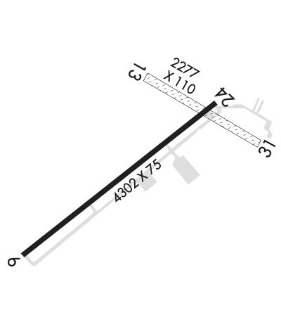
Runway Identifications
Runway Identification: 06/24Length: 4302 ft
Width: 75 ft
Surface: ASPHALT
Edge lights: Medium IntensityTreatment: NONE
| | Runway: 06 | | Runway: 24 |
| Mag heading: | 58° | Mag heading: | 238° |
| Rwy Slope: | .36% Up | Rwy Slope: | -.36% Down |
| Approach: | | Approach: | |
| Pattern: | Left Traffic | Pattern: | Left Traffic |
| Markings: | NONPRECISION INSTRUMENT | Markings: | NONPRECISION INSTRUMENT |
| Marking Condition: | GOOD | Marking Condition: | GOOD |
| Arresting Dev: | | Arresting Dev: | |
| Lat & Long: | N4327.2 W08327.2 | Lat. & Long.: | N4327.7 W08326.5 |
| Elev: | 684.8 ft. MSL | Elev: | 700.5 ft. MSL |
| TCH: | 40 ft. AGL | TCH: | 48 ft. AGL |
| Visual Glide Path: | 3.00 degrees | Visual Glide Path: | 3.50 degrees |
| Displaced Threshold: | No | Displaced Threshold: | No |
| Touchdown Zone: | YES | Touchdown Zone: | YES |
| Touchdown Elev.: | 688.8 feet | Touchdown Elev.: | 700.5 feet |
| Visual Glide Slope: | 4-Light PAPI on LEFT side of Runway; PAPI UNUSBL BYD 9 DEGS LEFT OF CNTRLN. | Visual Glide Slope: | 4-Light PAPI on LEFT side of Runway |
| RVR Equipment: | | RVR Equipment: | |
| RVV Equipment: | NO | RVV Equipment: | NO |
| Approach Lights: | | Approach Lights: | |
| REIL: | NO | REIL: | NO |
| Centerline Lights: | NO | Centerline Lights: | NO |
| Touchdown lights: | NO | Touchdown lights: | NO |
| Runway Category: | Runway with a Non-precision Approach | Runway Category: | Runway with a Non-precision Approach |
| Declared Distances: | | Declared Distances: | |
| Obstructions: | TREE | Obstructions: | TREE |
| Marked: | NOT Marked/Lighted | Marked: | NOT Marked/Lighted |
| Clearance slope: | 18:1 | Clearance slope: | 3:1 |
| Obstruction height: | 54 feet AGL | Obstruction height: | 39 feet AGL |
| Dist. from runway: | 1214 feet | Dist. from runway: | 355 feet |
| Centerline offset: | 250 right of centerline | Centerline offset: | 283 feet right of centerline |
| Comments: | | Comments: | |
Runway Identification: 13/31Length: 2277 ft
Width: 110 ft
Surface: GRASS-FAIR CONDITION
Edge lights: Treatment: NONE
| | Runway: 13 | | Runway: 31 |
| Mag heading: | 128° | Mag heading: | 308° |
| Rwy Slope: | -.67% Down | Rwy Slope: | .67% Up |
| Approach: | | Approach: | |
| Pattern: | Left Traffic | Pattern: | Left Traffic |
| Markings: | | Markings: | |
| Marking Condition: | YELLOW CONES. | Marking Condition: | RWY & DTHR MKD WITH YELLOW CONES. |
| Arresting Dev: | | Arresting Dev: | |
| Lat & Long: | N4327.7 W08326.7 | Lat. & Long.: | N4327.6 W08326.3 |
| Elev: | 704.3 ft. MSL | Elev: | 689.0 ft. MSL |
| TCH: | | TCH: | |
| Visual Glide Path: | | Visual Glide Path: | |
| Displaced Threshold: | No | Displaced Threshold: | 564 feet |
| Touchdown Zone: | YES | Touchdown Zone: | YES |
| Touchdown Elev.: | 704.3 feet | Touchdown Elev.: | 704.3 feet |
| Visual Glide Slope: | | Visual Glide Slope: | |
| RVR Equipment: | | RVR Equipment: | |
| RVV Equipment: | NO | RVV Equipment: | NO |
| Approach Lights: | | Approach Lights: | |
| REIL: | NO | REIL: | NO |
| Centerline Lights: | NO | Centerline Lights: | NO |
| Touchdown lights: | NO | Touchdown lights: | NO |
| Runway Category: | Runway with a Visual Approach | Runway Category: | Runway with a Visual Approach |
| Declared Distances: | | Declared Distances: | |
| Obstructions: | TREE | Obstructions: | TREE |
| Marked: | NOT Marked/Lighted | Marked: | NOT Marked/Lighted |
| Clearance slope: | 1:1; APCH RATIO 18:1 TO DTHR OVR +33 FT TREE, 594 FT DIST, 35 FT L. | Clearance slope: | 9:1; APCH RATIO 19:1 TO DTHR OVR +65 FT TREE, 1254 FT DIST, 107 FT L. |
| Obstruction height: | 14 feet AGL | Obstruction height: | 72 feet AGL |
| Dist. from runway: | 0 feet | Dist. from runway: | 691 feet |
| Centerline offset: | 95 right of centerline | Centerline offset: | 107 feet left of centerline |
| Comments: | | Comments: | |

