Click here for more info on on SMS!

KCFJ

CRAWFORDSVILLE MUNI
CRAWFORDSVILLE
IN
Time Zone: Eastern
Lat: N 3958.5
Long: W 08655.3
Elev: 800
Var: +04
Longest Runway: 5506
AWOS: 125.65
CTAF: 122.8

FBO & Flight Services info for KCFJ

FBOs: Update your Fuel Prices

  click here  
Providing high quality fuel and services to you and your customers from Phillips 66 Aviation.
Ph: 765-362-0070
-
Freq: 122.8WebsiteE-Mail
                               
Service
Jet
100LL
SAF
MoGas
Fuel Avail: 24/7 AVAIL; Terminal open 9a-5p (1300Z-2100Z) JetA NA UFN 5/2021
Full        Last Update: 03/22/2024 09:58

Self5.755.50    
Misc. Info: Jet A Discounts Available - call for additional information!Address: 759 W COUNTY RD 400 S,   CRAWFORDSVILLE, IN 47933

AWOSPh: 765-362-2967
-
Freq: 125.65  
If you are an FBO, call 1-203-262-1700 to update your info or email: FltPlan.Advertising@garmin.com
Advertise your FBO on FltPlan.com

Runway & Approach Info for KCFJ
Rwy
Length
Land Dist**
Approach*
  Rwy
Length
Land Dist**
Approach*
04
5506x75  5506'          
 
  
22
  5506x75  5004'          
 
 * only ILS, LOC, LDA, and SDF approaches to a specific runway are shown
** For any Declared Landing Distance Available, please see A/FD or Approach plates
Runway Weight Capability (lbs.) Help
Runway IDSingle WheelDouble WheelDouble Tandem WheelDual Double Wheel
04/2216,00025,000N/AN/A
These numbers are Advisory and are not limits.   The Airport Manager should have more accurate Weight Limits
Approach Charts
Approaches    
Current Weather/Notams
Customs Information Send updates to Support@FltPlan.com
Customs Not Available
Database effective 04/18/2024
Airport Diagram of KCFJ
Airport Diagram might not be current.

Facility Name: CRAWFORDSVILLE RGNL
City Name: CRAWFORDSVILLE
County: MONTGOMERY
State abbrev: IN
State Name: INDIANA
   
Ownership: PUBLICLY OWNED
Use: OPEN TO THE PUBLIC
Owner's Name: CITY OF CRAWFORDSVILLE
Address: 759 W 400 S
 CRAWFORDSVILLE, IN 47933
Owner's Phone: 765-362-0707
  
Manager's Name: LORI CURLESS
Address: 759 W 400 S
 CRAWFORDSVILLE, IN 47933
Phone: (765) 362-0707
   
FAA Region: GREAT LAKES
FAA Field Office: CHI


Sunrise / Sunset times for CRAWFORDSVILLE RGNL

DateSunriseSunset
04/18/24 Thursday7:0420:30
04/19/24 Friday7:0320:31
04/20/24 Saturday7:0120:32
04/21/24 Sunday7:0020:33
04/22/24 Monday6:5920:34
04/23/24 Tuesday6:5720:35
04/24/24 Wednesday6:5620:36
04/25/24 Thursday6:5520:37
04/26/24 Friday6:5320:38
04/27/24 Saturday6:5220:39
04/28/24 Sunday6:5120:40
04/29/24 Monday6:4920:41
04/30/24 Tuesday6:4820:42
05/01/24 Wednesday6:4720:43

Airport Facilities

Airport Attendance Schedule7 Days A Week 0900-1700
Airport Status OPERATIONAL (This Status can change at any time - please check NOTAMS)
Airport Lighting ScheduleACTVT REIL RWY 04 & 22 - CTAF. MIRL RWY 04/22 PRESET TO LOW INTST; INCR INTST - CTAF.
Airport Storage AvailableTie Downs, Hanger
Extra Services AvailableCrop Dusting, Flight Instruction, Aircraft Rental
Wind IndicatorYES - (lighted)
Control TowerNO
CTAF Frequency122.800
Unicom Frequency122.800
Rotating Beacon ColorWG
Segmented CircleNO
Landing FeeNO

Airport Inspection Data

Airport InspectedSTATE - performed by STATE AERONAUTICAL PERSONNEL
Inspection Date07/10/2023

Airport Services

Type of Fuel AvailableGrade 100LL, JET A (freeze point -40C), JET A
Airframe Repair ServiceMAJOR
Power Plant Repair ServiceMAJOR

Geographic Data

LatitudeN3958.5
LongitudeW08655.3 (ESTIMATED)
Arpt Elevation800ft (SURVEYED)
Magnetic Variation04W
4 miles Sof CRAWFORDSVILLE
Traffic Pattern Altitude
Sectional ChartST LOUIS

Aircraft Data

Operations (Reported)YearlyAvg. Daily
General Aviation Transient 779221
General Aviation Local 1513041
Air Taxi 00
Commerical 00
Commuter 00
Military 00
Aircraft based on Field
General Aviation Singles 29
General Aviation Multi 2
Jet Aircraft 0
General Aviation Helicopters 0
Military Aircraft 0
Gliders 0
Ultralights 0

FAA Services

FSS on field NO
FSS tie-in TERRE HAUTE
FSS Phone 1-800-WX-BRIEF
Who issues Notams HUF
Notam D service at airport YES
ARTCC Name INDIANAPOLIS

Federal Status

Airport Certification
Aircraft Rescue & Firefighting IndexNone
Airport of EntryNo
Custom Landing RightsNo
Joint Civil/MilitaryNo
Military Landing rightsYES

Federal Agreements

NATIONAL PLAN OF INTEGRATED AIRPORT SYSTEMS (NPIAS)
GRANT AGREEMENTS UNDER FAAP/ADAP/AIP
ASSURANCES PURSUANT TO TITLE VI, CIVIL RIGHTS ACT OF 1964

Remarks

ARPT CLSD TO PART 137 OPS EXCP PPR 765-362-0070.
FOR CD CTC INDIANAPOLIS APCH AT 317-227-5744.
Airport Communications & Frequencies:
CTAF Frequency:
122.800
Unicom Frequency:
122.800
INDIANAPOLIS Primary Approach Frequencies:  
119.05
317.8
INDIANAPOLIS Primary Departure Frequencies:  
119.05
317.8
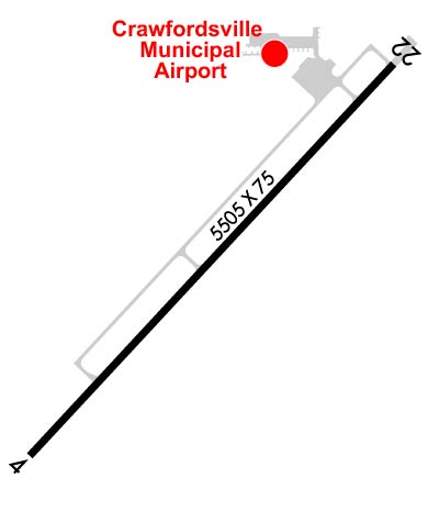
Runway Identifications
Runway Identification: 04/22
Length: 5506 ft
Width: 75 ft
Surface: ASPHALT-GOOD CONDITION
Edge lights: Medium Intensity

Treatment: GROOVED

 Runway: 04   Runway: 22
Mag heading: 47°Mag heading: 227°
Rwy Slope: .06% UpRwy Slope: -.06% Down
Approach: Approach:
Pattern: Left TrafficPattern: Left Traffic
Markings: NONPRECISION INSTRUMENTMarkings: NONPRECISION INSTRUMENT
Marking Condition: GOODMarking Condition: GOOD
Arresting Dev: Arresting Dev:
Lat & Long: N3958.1  W08655.7Lat. & Long.: N3958.8  W08654.9
Elev: 797.2 ft. MSLElev: 800.4 ft. MSL
TCH: 41 ft. AGLTCH: 42 ft. AGL
Visual Glide Path: 3.00 degreesVisual Glide Path: 3.00 degrees
Displaced Threshold: NoDisplaced Threshold: 502 feet
Touchdown Zone: YESTouchdown Zone: YES
Touchdown Elev.: 797.4 feetTouchdown Elev.: 799.4 feet
Visual Glide Slope: 4-Light PAPI on LEFT side of Runway; UNUSBL BYD 8 DEGS LEFT OF CNTRLN.Visual Glide Slope: 4-Light PAPI on LEFT side of Runway
RVR Equipment: RVR Equipment:
RVV Equipment: NORVV Equipment: NO
Approach Lights: Approach Lights:
REIL: YESREIL: YES
Centerline Lights: NOCenterline Lights: NO
Touchdown lights: NOTouchdown lights: NO
Runway Category: Runway with a Non-precision ApproachRunway Category: Runway with a Non-precision Approach
Declared Distances: Declared Distances:
Obstructions: CROPSObstructions: ROAD
Marked: NOT Marked/LightedMarked: NOT Marked/Lighted
Clearance slope: 16:1Clearance slope: 8:1; APCH RATIO 55:1 FM DSPLCD THR.
Obstruction height: 10 feet AGLObstruction height: 15 feet AGL
Dist. from runway: 360 feetDist. from runway: 324 feet
Centerline offset: Centerline offset: 280 feet right of centerline
Comments: Comments:
C:2/P: