Current Weather/Notams (Metars, TAFs, Notams, NWS Forecast, PIREPS, and nearby weather)
Customs Information Send updates to Support@FltPlan.com
Customs Not Available
Database effective 05/16/2024
Airport Diagram might not be current.
|
| Facility Name: | COULTER FLD |
| City Name: | BRYAN |
| County: | BRAZOS |
| State abbrev: | TX |
| State Name: | TEXAS |
| | |
| Ownership: | PUBLICLY OWNED |
| Use: | OPEN TO THE PUBLIC |
| Owner's Name: | CITY OF BRYAN |
| Address: | P. O. BOX 1000 |
| | BRYAN, TX 77803 |
| Owner's Phone: | 979-209-5233 |
| | |
| Manager's Name: | BRANDON REID |
| Address: | 6120 SH 21E |
| | BRYAN, TX 77808 |
| Phone: | 979-209-5233 |
| | |
| FAA Region: | SOUTHWEST |
| FAA Field Office: | TEX |
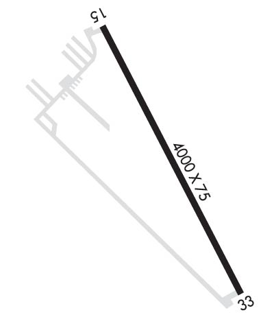
Runway Identifications
Runway Identification: 15/33Length: 4000 ft
Width: 75 ft
Surface: ASPHALT-FAIR CONDITION
Edge lights: Medium IntensityTreatment: NONE
| | Runway: 15 | | Runway: 33 |
| Mag heading: | 148° | Mag heading: | 328° |
| Rwy Slope: | .24% Up | Rwy Slope: | -.24% Down |
| Approach: | | Approach: | |
| Pattern: | Left Traffic | Pattern: | Left Traffic |
| Markings: | NONPRECISION INSTRUMENT | Markings: | NONPRECISION INSTRUMENT |
| Marking Condition: | FAIR | Marking Condition: | FAIR |
| Arresting Dev: | | Arresting Dev: | |
| Lat & Long: | N3043.2 W09620.1 | Lat. & Long.: | N3042.7 W09619.7 |
| Elev: | 357.2 ft. MSL | Elev: | 366.7 ft. MSL |
| TCH: | 40 ft. AGL | TCH: | 40 ft. AGL |
| Visual Glide Path: | 3.50 degrees | Visual Glide Path: | 3.50 degrees |
| Displaced Threshold: | No | Displaced Threshold: | No |
| Touchdown Zone: | YES | Touchdown Zone: | YES |
| Touchdown Elev.: | 360.9 feet | Touchdown Elev.: | 366.7 feet |
| Visual Glide Slope: | 2-Light PAPI on LEFT side of Runway | Visual Glide Slope: | 2-Light PAPI on LEFT side of Runway |
| RVR Equipment: | | RVR Equipment: | |
| RVV Equipment: | NO | RVV Equipment: | NO |
| Approach Lights: | | Approach Lights: | |
| REIL: | YES | REIL: | YES |
| Centerline Lights: | NO | Centerline Lights: | NO |
| Touchdown lights: | NO | Touchdown lights: | NO |
| Runway Category: | Runway with a Non-precision Approach | Runway Category: | Runway with a Non-precision Approach |
| Declared Distances: | | Declared Distances: | |
| Obstructions: | TREES | Obstructions: | BRUSH |
| Marked: | LIGHTED | Marked: | NOT Marked/Lighted |
| Clearance slope: | 9:1; CONTROLLING OBSTRUCTION EXCEEDS A 45 DEGREE SLOPE | Clearance slope: | |
| Obstruction height: | 30 feet AGL | Obstruction height: | 10 feet AGL |
| Dist. from runway: | 480 feet | Dist. from runway: | 201 feet |
| Centerline offset: | 280 left of centerline | Centerline offset: | 199 feet right of centerline |
| Comments: | | Comments: | |

